The Dead Sea (al-Baḥr al-Mayyit, البحر الميت) is a hypersaline endorheic lake situated in the Jordan Rift Valley of Western Asia, bordered by Jordan to the east and Israel/Palestine and the West Bank to the west, and distinguished by its extreme salinity, mineral-rich waters, and position as the lowest exposed point on the Earth’s continental surface.
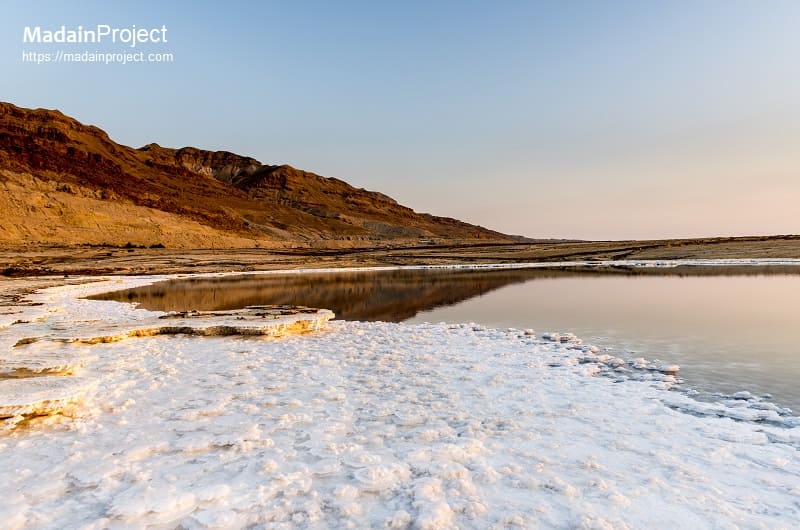
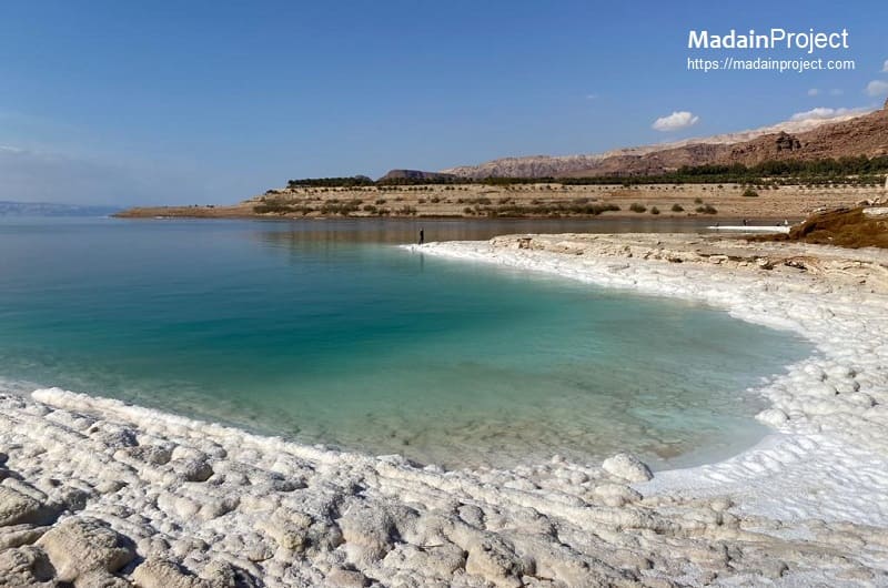
Located approximately 430 meters below mean sea level, the Dead Sea occupies a tectonic depression formed along the Dead Sea Transform, a major strike-slip fault system separating the African and Arabian plates. The lake extends roughly 50 kilometers from north to south and up to 15 kilometers in width, though its dimensions have fluctuated markedly in historical and modern times. Its salinity, averaging about 34 percent by mass, is nearly ten times that of typical ocean water, a condition that inhibits the survival of most macroscopic aquatic organisms and gives rise to the name “Dead Sea”.
The water chemistry is dominated by magnesium, sodium, calcium, potassium, and chloride ions, with an unusually low proportion of sulfate compared to seawater. These properties have long underpinned the region’s economic importance, particularly for mineral extraction and therapeutic uses, while also making the lake a natural laboratory for geophysical, geochemical, and climatological research.
circa 15-20 million years-

The geological origin of the Dead Sea is inseparable from the tectonic evolution of the Dead Sea Transform fault system, which began forming during the early Miocene epoch, approximately 15-20 million years ago. This tectonic depression was shaped by a 107 kilometers left-lateral displacement along the DST, accompanied by significant subsidence and margin uplift. Left-lateral strike-slip motion between the African and Arabian plates generated a series of pull-apart basins, one of which became the Dead Sea basin. Progressive subsidence created accommodation space for thick accumulations of sediments and evaporites, with some deposits exceeding several kilometers in depth. During the late Miocene to early Pliocene, the basin was periodically inundated by Mediterranean waters via the Jezreel Valley, forming the Sedom Lagoon. Intense evaporation in this restricted marine environment deposited massive evaporite sequences, including the Sedom Formation, which reaches thicknesses of several kilometers and currently forms rising salt diapirs such as Mount Sedom.
During the late Neogene and early Quaternary periods, the basin was intermittently occupied by precursor lakes whose extents and salinities fluctuated in response to regional climatic shifts. The most prominent of these was Lake Lisan, which existed between roughly 70,000 and 15,000 years ago during the last glacial cycle. Lake Lisan was significantly larger and less saline than the modern Dead Sea, extending from the Sea of Galilee in the north to the Hula Basin in the south. Its sediments, known as the Lisan Formation, consist of finely laminated aragonite and detrital marl layers that record high-resolution paleoclimatic variations linked to glacial–interglacial cycles.
Following the Pliocene disconnection from the Mediterranean, the basin hosted a series of terminal lakes whose levels fluctuated in response to Quaternary climatic shifts. Notable precursors include Lake Amora (circa 740–70 kiloannum) and Lake Lisan (circa 70–14 kiloannum). Lake Lisan was a vast brackish water body that reached its highest stand of approximately 160–170 meters below sea level during the Last Glacial Maximum (circa 26 kiloannum), roughly 270 meters higher than current levels. The transition to the modern Dead Sea occurred roughly 11,000 to 10,000 years ago as post-glacial aridity caused rapid regression and concentrated the remaining brine into its current hypersaline state.
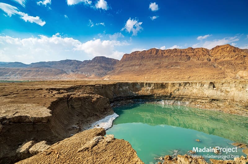
As the climate became warmer and drier during the terminal Pleistocene and early Holocene, Lake Lisan underwent rapid regression, fragmenting into smaller water bodies and eventually giving rise to the modern Dead Sea. Reduced freshwater input and enhanced evaporation led to the concentration of dissolved salts and the precipitation of evaporite minerals, including halite, gypsum, and carnallite, on the lake floor and along marginal zones. These processes continue today, contributing to the formation of subaqueous salt layers and shoreline salt crusts.
Throughout its history, the Dead Sea has been highly sensitive to hydrological balance. Even modest changes in precipitation or inflow have produced substantial variations in lake level, salinity, and stratification. In the late Holocene, the lake alternated between periods of stable stratification and complete mixing, influencing oxygen availability and mineral precipitation at depth. The extreme chemical environment has limited biological activity largely to specialized halophilic microorganisms, whose episodic blooms are tied to rare dilution events following periods of increased freshwater inflow.
circa 15-20 million years-

Human interaction with the Dead Sea can be traced to prehistoric settlement patterns along its freshwater-fed margins, particularly near oases such as Ein Gedi and Jericho, one of the earliest continuously inhabited cities in the world.
During the Neolithic period (circa 10,000 BCE), with evidence of semi-sedentary communities at Jericho utilizing the nearby springs. By the Chalcolithic and Early Bronze Age, the region saw the development of specialized urban centers such as Bab edh-Dhra and Numeira on the eastern shore. These early civilizations engaged in advanced agricultural practices and the systematic extraction of minerals. Chemical fingerprinting has confirmed that bitumen (asphalt)—periodically released from deep-seated faults in the lakebed—was harvested as early as the 9th millennium BCE and traded extensively across the Near East for use as an adhesive and waterproofing agent.
In the Bronze Age, the region lay within trade networks connecting the Levant with Arabia and Mesopotamia, and bitumen harvested from the Dead Sea was exported for use in construction, waterproofing, and funerary practices, including Egyptian mummification. Ancient Egyptian texts from the second millennium BCE refer to the area as a source of asphalt, indicating organized extraction and trade.
In biblical and Iron Age traditions, the Dead Sea region was associated with the Cities of the Plain, including Sodom and Gomorrah, narratives that reflect the area’s geological instability and the presence of sulfur and bitumen deposits. During the First Temple period, the eastern and western shores fell under the influence of Israelite, Moabite, and Edomite polities.
During the Hellenistic era and Roman period, the Dead Sea gained strategic and economic significance. Classical authors such as Strabo and Pliny the Elder described its unusual buoyancy and asphalt deposits, the latter of which were harvested and traded for use in construction and embalming. The ancient fortress of Masada, built and expanded under Herod the Great in the late first century BCE, overlooks the western shore and became the site of a well-documented siege during the First Jewish–Roman War in 73–74 CE. In the Byzantine and early Islamic periods, monastic communities and agricultural settlements developed in the surrounding wadis and plateaus, adapting to the arid environment through irrigation and terracing.
Under Ottoman rule, the Dead Sea region remained sparsely populated but continued to be noted by travelers and scholars for its geography and mineral wealth. Systematic scientific exploration intensified in the nineteenth century CE, with surveys by European and American expeditions, including the United States Navy expedition led by William Francis Lynch in 1848 CE, which produced some of the earliest precise measurements of depth and elevation. In the twentieth century CE, industrial exploitation expanded with the establishment of potash and mineral extraction enterprises on both the eastern and southern shores, coinciding with shifting political boundaries following the end of the Ottoman Empire and the subsequent Arab–Israeli conflicts. These developments have left a lasting imprint on both the physical landscape and the human history of the Dead Sea basin.
circa

Masada and the Roman Siege
Ancient Masada remains the most strategically prominent site, featuring a massive Herodian fortress-palace situated atop a natural plateau approximately 450 meters above the western shore of the Dead Sea. Recent 3D-modeling and drone research as of 2024 and 2025 has revised the historical narrative of the Roman siege of 73–74 CE, suggesting the operation was a "precision strike" lasting only four to nine weeks rather than a years-long multi-stage campaign. The site preserves an extensive water management system and Roman-style bathhouses with original mosaic floors, underscoring the architectural sophistication achieved in this hyper-arid environment.
Qumran and the Essene Context
On the northwestern shore, the site of Qumran is synonymous with the discovery of the Dead Sea Scrolls between 1947 and 1956 CE. Archaeological features at Qumran include a communal scriptorium, sophisticated ritual purification pools (miqva'ot), and a cemetery, which scholars associate with the Essenes, an ascetic Jewish sect. As of 2026 CE, the archaeological site remains a central hub for studying Second Temple period life, with ongoing digital reassembly of scroll fragments utilizing DNA analysis and multispectral imaging.
En-Gedi: The Industrial Oasis
En-Gedi functions as a prime example of an ancient industrial oasis, with a history of permanent settlement extending from the Chalcolithic temple (circa 4000 BCE) to a thriving Byzantine community. It was a world-renowned center for the production of balsam perfume, with excavations revealing workshops specifically designed for distilling aromatic resins. Current research projects scheduled through 2026–2029 CE at Tel Goren are focused on identifying the specific industrial installations and socioeconomic shifts following the 586 BCE destruction of the Kingdom of Judah.
Secondary Sites
Other secondary sites include, baptismal site (al-Maghtas, المغطس) of Jesus on the east bank of the Jordan River. Jericho, situated north-west of the Dead Sea's northern extermity, is one of the most notable and the ancient most archaeological site. Also, situated approx. north-east of the northern edge of the Dead Sea is another notable archaeological site. Another notable site is the Sanctuary of Agios Lot. Anoth site is the Mount Sodom.
Signup for our monthly newsletter / online magazine.
No spam, we promise.
The Madain Project is an online archive of Abrahamic History and Archaeology.
Abrahamic History & Archaeology is the study of history and archaeology with respect to the three Abrahamic Faiths without considering the religious and theological aspects. The goal of Abrahamic History is to understand how and why the religious doctrines and behaviours have evlovled and changed over time. Searching for patterns in the evolution of significant cultural events such as the development of farming, the emergence of cities, or the collapse of major civilizations for clues of why and how these have influenced the three major Abrahamic religions.
Cloud Drive -
About -
Help -
Editorial Policy -
AI Policy -
Privacy Policy -
Contact
Madain Project: Encyclopedia of Abrahamic History & Archaeology.
Copyright MadainProject 2017 - 2026.
![]()
![]()
![]()
![]()
![]()
![]()