Ancient Jordan (الأردن), today officially called the Hashemite Kingdom of Jordan (المملكة الأردنية الهاشمية) is an Arab country in Western Asia, on the East Bank of the Jordan River. Jordan is rich in Paleolithic (up to 20,000 years ago) remains due to its location within the Levant where expansions of hominids out of Africa converged. Fortified towns and urban centers first emerged in the southern Levant early on in the Bronze Age (3600–1200 BCE). The Transjordanian kingdoms of Ammon, Edom and Moab were in continuous conflict with the neighbouring Hebrew kingdoms of Israel and Judah, centered west of the Jordan River.
Back to Asia / Middle East / Levant
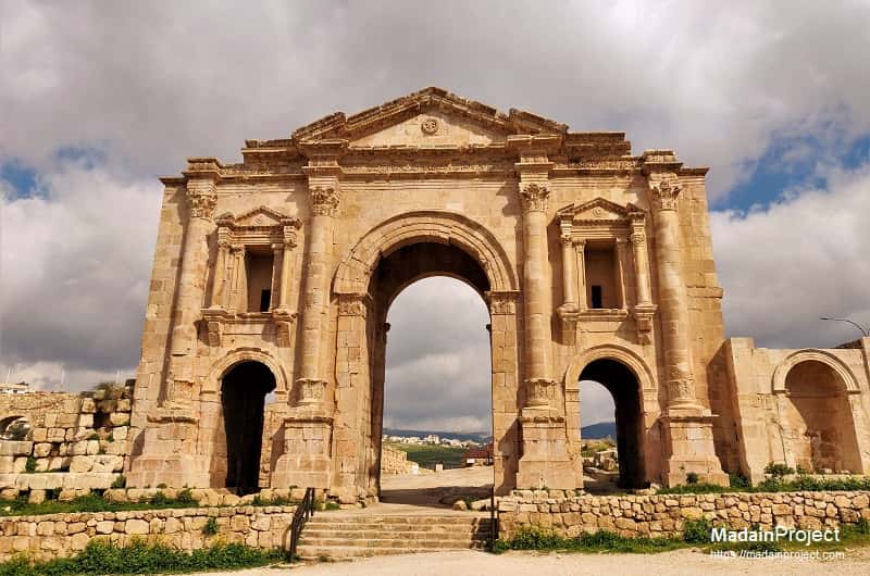
Jerash, ancient Gerasa, provide a remarkable glimpse into its grandeur during antiquity. The imposing Arch of Hadrian, the Oval Plaza, and the stunning South Theater are just a few of the architectural marvels that showcase the city's prosperity and cultural sophistication. The intricate colonnaded streets, temples, and public buildings reflect Jerash's significance as a major center of trade, commerce, and governance in the Roman Empire. Read more

Petra's unique location, hidden amid towering rock formations, contributed to its strategic significance as a center for trade and commerce, especially in the caravan routes that connected the Arabian Peninsula with the Mediterranean. The intricate rock-cut architecture showcases the advanced engineering skills of the Nabataeans, who created a water conduit system to channel and store water for the city. Read more

With evidence of human settlement dating back to the Neolithic period, the Citadel has served as a strategic location for various cultures, including the Romans, Byzantines, and Umayyads. One of the notable structures within the Citadel is the Temple of Hercules, believed to have been built during the reign of Roman Emperor Marcus Aurelius (161-180 CE). The Amman Citadel's panoramic views of the modern city juxtaposed against the ancient ruins create a captivating experience for visitors. Read more

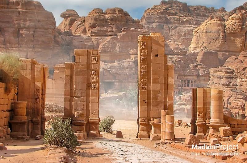
The so-called Treasury (or al-Khazneh) is one of the most famous rock-cut façades of the iconic monuments of Petra. Added to the "New Wonders of the World" list in 2007 CE, it is known to most people as the scene of the climax of the hit movie, Indiana Jones and the Last Crusade, in which it is portrayed as the location of the legendary Holy Grail. However, in reality, it was built possibly as early as the fifth century BCE by the Nabataeans, a culture of traders who established the city. The Nabataeans had staged this overture when entering their capital from the east in a far more imposing manner than the present sight suggests.
According to biblical accounts, Lot, the nephew of the patriarch Abraham, sought refuge in this cave with his two daughters after fleeing the destruction of the cities of Sodom and Gomorrah. The narrative describes the cave as a place where Lot and his daughters lived in isolation. The story of Lot's Cave is primarily recounted in Genesis 19:30-38, illustrating the challenges faced by Lot and his family in the aftermath of the destruction of Sodom. Read more

Constructed in the early 8th century during the Umayyad Caliphate, Qusayr 'Amra is part of a group of desert castles that served various purposes, including as hunting lodges, bathhouses, and retreats. The structure is particularly famous for its frescoes that adorn the interior walls and ceilings. These vibrant paintings depict a wide range of subjects, including scenes of nature, hunting, dancing, and portraits of rulers. Read more
The mosque is situated within the ruins of a historical Umayyad fortress, known as Qasr al-Hallabat, which dates back to the 8th century. The mosque is recognized for its architectural and historical significance, representing the Umayyad period's influence in the region. The structure exhibits elements of early Islamic architecture, with characteristic features such as horseshoe arches and decorative motifs. Read more
The South Tetrapylon marked the cross between the Cardo Maximus and the Southern Decumanus. It is supposed there were four tower-like constructions, each on a corner, consisting of a podium on each of which would stand four Corinthian columns with a highly decorated entablature. The southern tetrapylon was a tetrakionion: a special type of tetrapylon in which the central crossing is not roofed. The four corner-markers still exist as four separate basement supporting four columns covered by a plane surface decorated with statues.


The Cave of the Seven Sleepers, also known as Ashab al-Kahf, is a significant religious and historical site located in Jordan. The cave is associated with a well-known Quranic narrative that tells the story of a group of young men who sought refuge in a cave to escape religious persecution during the time of a tyrannical ruler. Read more
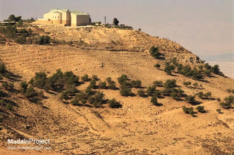
Mount Nebo is a significant historical and religious site located in western Jordan, near the town of Madaba. It holds great importance in Judeo-Christian tradition, as it is believed to be the place where Moses viewed the Promised Land before his death, as mentioned in the Bible. The Mount Nebo is home to the Memorial Church of Moses. Read more

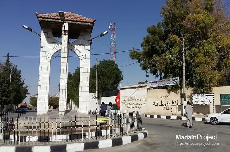
The maqam or shrine dedicated to Bilal ibn Rabaha is a contemporary standalone domed structure situated within the Bilal ibn Rabah Mosque, located in the village of Bilal in Amman, the capital of Jordan. Some historians contend that Bilal's real grave is at the Bab al-Saghir cemetery in Damascus, Syria. Read more
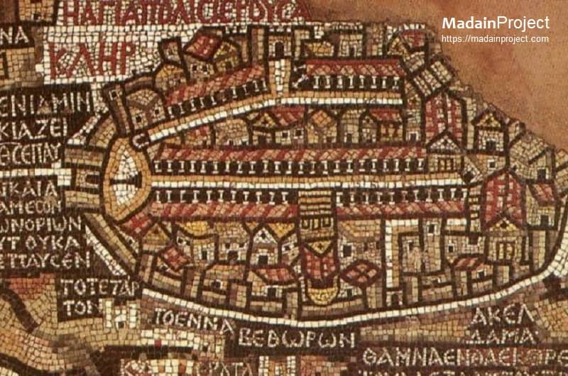
The Mādabā mosaic map, thought to be the oldest surviving map of Palestine and the neighbouring territories. The mosaic map, which formed the floor of one of the many ruined ancient churches in Mādabā, was discovered in 1884. The map dates from the 6th century CE, was originally 72 by 23 feet (22 by 7 metres) in size, and showed the area from ancient Byblos (modern Jubayl, Leb.) in the north to Thebes (Egypt) in the south and from the Mediterranean Sea in the west to Amman, Al-Karak, and Petra in the east.

The Memorial Church of Moses on Mount Nebo is a prominent religious and historical site located in western Jordan. Mount Nebo holds significance in Abrahamic traditions, as it is believed to be the place where Moses viewed the Promised Land before his death. The church features significant archaeological finds, including ancient mosaics from the 4th to 6th centuries. Read more

The Tomb of Aaron is a significant religious and historical site located on Mount Hor, near Petra in Jordan. According to Abrahamic traditions, Aaron, the brother of Moses and a prominent figure in the Bible and the Quran, is believed to have been buried at this site. The tomb itself is a modest structure, and pilgrims and visitors come to pay their respects to Aaron and reflect on the religious significance of the site. Read more
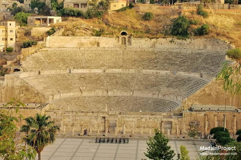
The Roman Theatre of Amman, also known as the Amman Citadel Theatre, is a well-preserved ancient amphitheater located in the heart of downtown Amman, Jordan. Constructed during the Roman period, likely in the 2nd century CE, the theater is a testament to the architectural and cultural legacy of the Roman Empire in the region. Read more
The Qasr al-Abd, also known as Qasr iraq al-Amir, is a large Hellenistic palace from approximately 200 BCE, whose ruins stand in western Jordan in the valley of Wadi Seer. The centerpiece of a grand second-century BCE estate built by the Jewish Tobiad family (known today as 'Iraq al Amir), it has long been a mystery why the Tobiads built this impressive structure. Based on the monument's elaborate design, decoration and the evidence from the 'Iraq al-Amir estate, Stephen Rosenberg, author of "'Castle of the Slave'—Mystery Solved' in the May/June 2012 issue of Biblical Archaeology Review, proposes the ruin was actually the burial monument of the Tobiads, modeled after the mausoleum at Halicarnassus, one of the seven wonders of the ancient world.


Tell el-Hammam, also known as Tall el-Hammam, is an archaeological site located in the Jordan Valley, near the northern tip of the Dead Sea. The site has garnered significant attention due to its potential identification with the biblical city of Sodom, although this association is a matter of scholarly debate. Read more
Dhiban is an ancient settlement in the present‑day Madaba Governorate of Jordan whose locality fell within the territorial bounds of the Emirate of Transjordan, a British protectorate established in 1921 under the auspices of the Mandatory system following the collapse of Ottoman rule in the Levant. The Emirate of Transjordan, administered by the Hashemite Emir Abdullah under British oversight, constituted the foundational framework of emergent Jordanian statehood until formal independence in 1946. Read more
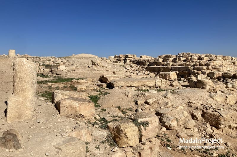
The archaeological site of Dhiban, located in the Madaba Governorate of central Jordan, represents a multi‑millennial sequence of human settlement and material culture that extends from the Early Bronze Age into the Islamic period. Excavations at the tell have uncovered evidence of occupation spanning roughly 5,000 years, reflecting its strategic position on the ancient King’s Highway and its role within successive cultural and political landscapes, including its prominence as the Iron Age capital of the Moabite kingdom known as Dibon and its association with the Mesha Stele, a ninth‑century BCE basalt inscription documenting Moabite political history.
Signup for our monthly newsletter / online magazine.
No spam, we promise.
The Madain Project is an online archive of Abrahamic History and Archaeology.
Abrahamic History & Archaeology is the study of history and archaeology with respect to the three Abrahamic Faiths without considering the religious and theological aspects. The goal of Abrahamic History is to understand how and why the religious doctrines and behaviours have evlovled and changed over time. Searching for patterns in the evolution of significant cultural events such as the development of farming, the emergence of cities, or the collapse of major civilizations for clues of why and how these have influenced the three major Abrahamic religions.
Cloud Drive -
About -
Help -
Editorial Policy -
AI Policy -
Privacy Policy -
Contact
Madain Project: Encyclopedia of Abrahamic History & Archaeology.
Copyright MadainProject 2017 - 2026.
![]()
![]()
![]()
![]()
![]()
![]()