al-Maghtas (Arabic: المغطس, lit. “the place of immersion”) is an archaeological and religious site on the eastern bank of the Jordan River in the present day Hashemite Kingdom of Jordan. It is widely identified with Bethany Beyond the Jordan, the location traditionally associated in Christian sources with the baptism of Jesus by John the Baptist. The site lies within the lower Jordan Valley, north of the Dead Sea, in a semi-arid landscape shaped by ancient river courses and springs.
Situated within the lower Jordan Valley, al-Maghtas lies just east of the river, primarily concentrated around the spring-fed wadi known today as Wadi al-Kharrar. The site forms part of a broader ritual and monastic landscape extending from the riverbank inland toward a low ridge historically associated with the prophet Elijah. For nearly two millennia, al-Maghtas has been a focal point of Christian pilgrimage, memory, and liturgy, revered as the locus of events that inaugurated the public ministry of Jesus.
Its significance rests not only on biblical tradition but also on extensive archaeological evidence documenting continuous religious use from the Roman and Byzantine periods through the early Islamic era. In 2015 CE, al-Maghtas was inscribed on the UNESCO World Heritage List as a cultural site of outstanding universal value, reflecting its central place in Christian sacred geography.
circa 200 CE
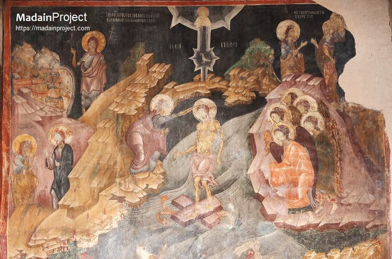
The identification of the present day al-Maghtas site with the “Bethany beyond the Jordan” derives primarily from the Gospel of John, which locates John the Baptist’s ministry and the baptism of Jesus east of the river. Early Christian writers, including Origen in the third century CE and Eusebius of Caesarea in the fourth CE, preserved and elaborated this geographical tradition, distinguishing the baptismal site from similarly named locations west of the Jordan. By the late Roman period (later Roman Empire period), Christian pilgrims were visiting the area in growing numbers, a movement attested by travel accounts such as the Itinerarium Burdigalense of 333 CE and later by Theodosius and the Piacenza Pilgrim in the sixth century CE.
During the Byzantine period, roughly from the fifth to the early seventh century CE, the site of al-Maghtas developed into a complex ritual landscape. Churches, baptismal installations, monasteries, and hermit dwellings were constructed to accommodate pilgrims and ascetics drawn to the site’s sanctity. The area around Wadi al-Kharrar became particularly prominent, as pilgrims believed its waters to be linked to the Jordan at the point of Jesus's baptism. Nearby, a hill known in Christian tradition as the place where the prophet Elijah ascended to heaven further enhanced the site’s scriptural resonance.
Following the Muslim conquest of the Levant in the seventh century CE, Christian activity at al-Maghtas declined but did not disappear. Evidence suggests intermittent use during the Umayyad era and subsequent Abbasid period, with some structures adapted or maintained for local Christian communities. Over subsequent centuries, changes in the course of the Jordan River, regional instability, and shifting pilgrimage routes led to the gradual abandonment and obscurity of the site. Its precise location remained a matter of scholarly debate until systematic archaeological surveys and excavations conducted in the late twentieth century CE, particularly from the 1990s onward, confirmed the eastern bank identification through material evidence consistent with early textual descriptions.
circa 200 CE
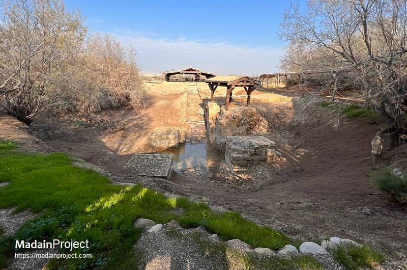
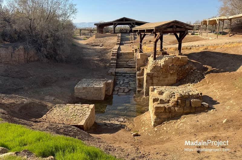
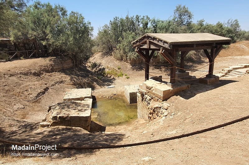
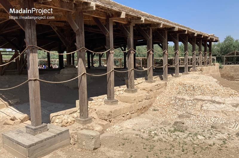
The architectural remains at al-Maghtas reflect its primary function as a baptismal and pilgrimage center rather than as an urban settlement. Excavations have revealed the foundations of multiple Byzantine churches, most notably small basilical structures oriented toward the river. These churches were typically constructed of local limestone, with mosaic floors and simple apses, and were often rebuilt or modified over successive phases, indicating long-term ritual use. Some were erected directly adjacent to water channels, emphasizing the centrality of flowing water to baptismal rites.
A distinctive feature of the site is the presence of baptismal pools and channels fed by springs from Wadi al-Kharrar. These installations suggest controlled liturgical use of water, allowing pilgrims to undergo ritual immersion without entering the main current of the Jordan River. Stone-lined pools, plastered to ensure water retention, were connected by narrow channels that directed spring water toward the river, symbolically uniting the two sources.
Scattered across the surrounding area are the remains of monastic cells and hermit caves, cut into the soft marl and limestone. These modest dwellings, often consisting of a single chamber with minimal architectural embellishment, testify to the ascetic character of the landscape, particularly in Late Antiquity. On the elevated ground traditionally associated with Elijah, archaeologists have identified remnants of chapels and lookout structures, possibly reinforcing the site’s layered biblical associations.
circa 542-570 CE
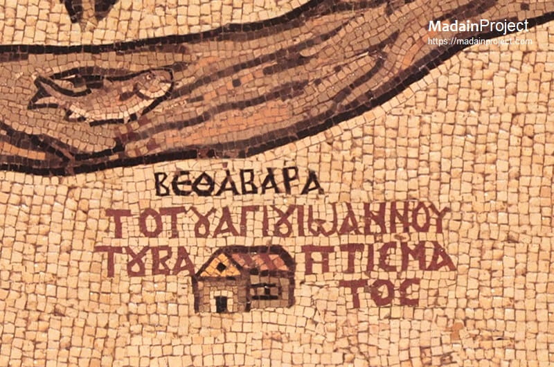
The sixth-century Madaba Mosaic Map is widely regarded as preserving a visual reference to the Christian tradition of the baptism of Jesus that is plausibly associated with al-Maghtas, though the identification cannot be considered definitive. On the map, a baptismal site is labeled in Greek as ΒΕΘΑΒΑΡΑ (Bethabara) and placed near the Jordan River opposite Jericho. This name is attested in early Christian literature as an alternative designation for Bethany beyond the Jordan, a variation already discussed by Origen in the third century CE, who sought to reconcile divergent manuscript traditions of the Gospel of John.
The cartographic representation on the Madaba Map situates Bethabara on the western side of the Jordan River, whereas literary sources and archaeological evidence consistently place the baptism site east of the river, corresponding to al-Maghtas. This displacement is generally interpreted as a product of the map’s symbolic and theological character rather than an attempt at precise geographical accuracy. The Madaba Map frequently compresses space, relocates sites, and prioritizes sacred meaning over topographical fidelity, limiting its value as a strictly cartographic document.
Iconographic elements on the map, including the emphasized course of the Jordan River and associated baptismal symbolism, support the conclusion that the labeled Bethabara refers specifically to the locus of Christ’s baptism as understood in Byzantine Christian tradition. However, because the map does not provide unambiguous spatial markers distinguishing the river’s eastern and western banks, it cannot be used to conclusively identify the physical location of the site.
Accordingly, modern scholarship characterizes the Madaba Map’s depiction as a probable reflection of the baptismal tradition later archaeologically documented at al-Maghtas, rather than as a definitive visual attestation of the site itself. Within a historical framework, the map is therefore understood as corroborating the existence and prominence of the baptism tradition in Late Antiquity, while remaining insufficient on its own to establish precise topographical identification.
Signup for our monthly newsletter / online magazine.
No spam, we promise.
The Madain Project is an online archive of Abrahamic History and Archaeology.
Abrahamic History & Archaeology is the study of history and archaeology with respect to the three Abrahamic Faiths without considering the religious and theological aspects. The goal of Abrahamic History is to understand how and why the religious doctrines and behaviours have evlovled and changed over time. Searching for patterns in the evolution of significant cultural events such as the development of farming, the emergence of cities, or the collapse of major civilizations for clues of why and how these have influenced the three major Abrahamic religions.
Cloud Drive -
About -
Help -
Editorial Policy -
AI Policy -
Privacy Policy -
Contact
Madain Project: Encyclopedia of Abrahamic History & Archaeology.
Copyright MadainProject 2017 - 2026.
![]()
![]()
![]()
![]()
![]()
![]()