The Madaba Map (also known as the Madaba Mosaic Map) is part of a floor mosaic in the early Byzantine church of Saint George at Madaba, present day Jordan. The Madaba Map depicts parts of the Middle East. Dating back to the sixth century CE, part of it contains the oldest surviving original cartographic depiction of the Holy Land and especially the historic city of Jerusalem. This mosaic may very well be the contemporary of Mount Nebo Mosaics.
The mosaic map of Madaba is the oldest known geographic floor mosaic in art history. The mosaic was made by unknown artists, probably for the Christian community of Madaba, which was the seat of a bishop at that time. In 614 CE, Madaba was conquered by the Sasanian Empire. In the eighth century CE, the ruling Muslim Umayyad Caliphate had some figural motifs removed from the mosaic.
The mosaic was rediscovered in 1884 CE, during the construction of a new Greek Orthodox church on the site of its ancient predecessor. Patriarch Nicodemus I of Jerusalem was informed, but no research was carried out until 1896 CE. In the following decades, large portions of the mosaic map were damaged by fires, activities in the new church and by the effects of moisture. In 1965 CE, major restoration works were carried out for the restoration and conservation of the remaining parts of the mosaic.
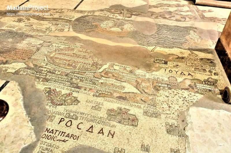
The mosaic map depicts an area from Lebanon in the north to the Nile Delta in the south, and from the Mediterranean Sea in the west to the Eastern Desert. Among other features, it depicts the Dead, a variety of bridges, fish swimming in the river; a lion hunting a gazelle in the Moab desert, palm-ringed Jericho, Bethlehem and other biblical-Christian sites. The map may partially have served to facilitate pilgrims' orientation in the Holy Land.
circa 570 CE

The floor mosaic is located in the apse of the church of Saint George at Madaba. It is not oriented northwards, like modern maps, but faces east towards the altar in such a fashion that the position of places on the map coincides with the actual compass directions. Originally, it measured 21 by 7 meters and contained over two million tesserae. Its current dimensions are 16 by 5 meters.
circa 570 CE

In December 1964, the Volkswagen Foundation gave the Deutscher Verein für die Erforschung Palästinas ("German Society for the exploration of Palestine") 90,000 DM to save the mosaic. In 1965, the archaeologists Heinz Cüppers and Herbert Donner undertook the restoration and conservation of the remaining parts of the mosaic.
circa 570 CE
City of Jerusalem
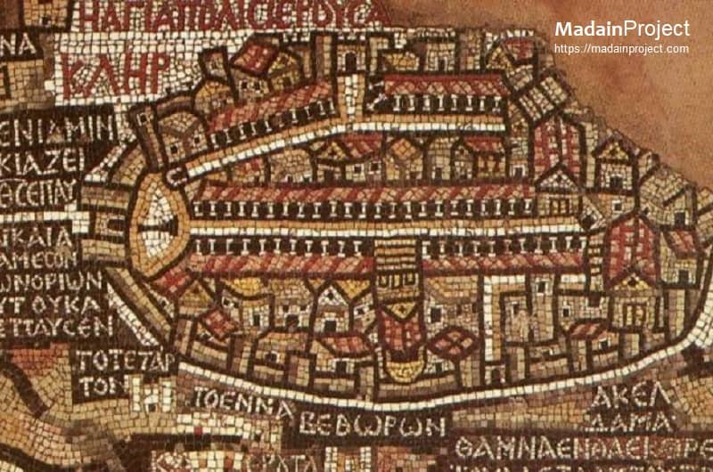
The depiction of Jerusalem in the Madaba Map is the largest and most detailed element of the topographic representation. The part of map that depicts Jerusalem with the Nea Church, dedicated in CE 542. Buildings erected after 570 are absent from the depiction, thus limiting the date range of its creation to the period between 542 and 570. Landmarks depicted include Cardo, Damascus Gate, Sepulchre, and David's Tower among others.
circa 570 CE

River Jordan
The river Jordan, depicting the baptismal location of John at the mouth of the Jordan river with fish swimming in the water and (near-obliterated) lion hunting a gazelle just above it in the Moab desert. The dead sea is also visible partially with one of the two fishing boats, a variety of bridges linking the banks of the Jordan, fish swimming in the river and receding from the Dead Sea.
circa 570 CE

Possible Depiction of Tell el-Hammam
The Madaba Mosaic Map portrays a significant yet unnamed location (inspect), nestled among date trees, near the upper-left corner of the Dead Sea just above where the Jordan River meets the Dead Sea. Over the past few decades, numerous attempts have been made to link it to various ancient archaeological sites, including Tall Iktanu, Tall Kefrein, Tall Nimrin, Tall Rameh, and Khirbet Sweimeh. Unfortunately, the upper part of the Madaba Map depicting the ancient site has not survived, and there is a possibility that the identification or name of the site may have been recorded there, leading to numerous speculations. David E. Graves and Scott Stripling suggest that it is likely the archaeological site now recognized as Tel el-Hammam.
circa 570 CE

Tomb of Joseph (Shechem)
The Madaba Mosaic Map (6th century) designates a site somewhat problematically with the legend – "Joseph's" (τὸ τοῦ Ὶωσήφ) – where the usual adjective 'holy' (hagios) accompanying mentions of saints and their shrines is lacking. It might be a possible depiction of Joseph's Tomb, located in Shechem (Nablus).
circa 570 CE
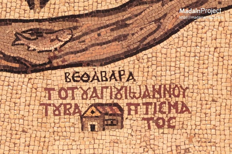
Bethabara
Bethabara appears on the Madaba Mosaic Map as a labeled baptismal site (commonly identified with al-Maghtas) associated with the Jordan River and the New Testament account of the baptism of Jesus by John the Baptist. The name is rendered in Greek as ΒΕΘΑΒΑΡΑ and is positioned near the river opposite Jericho, reflecting the sixth-century Byzantine understanding of the location connected with this foundational Christian event. Its inclusion on the map indicates the established importance of the baptism tradition within Late Antique Christian sacred geography.
The toponym Bethabara derives from an alternative textual tradition of the Gospel of John (John 1:28), where it appears in some manuscripts in place of Bethany beyond the Jordan. Origen, writing in the third century CE, explicitly addressed this variation, favoring Bethabara on the grounds that no place named Bethany was known east of the Jordan in his time. As a result, Bethabara entered Christian geographical usage as a recognized designation for the baptism site, particularly in Byzantine-period liturgical and pilgrimage contexts.
On the Madaba Map, Bethabara’s placement on the western side of the Jordan does not correspond precisely with earlier literary traditions that situate the baptism east of the river. This inconsistency is generally attributed to the schematic nature of the mosaic, which prioritizes theological meaning and recognizability over strict spatial accuracy. Similar positional displacements are observed elsewhere on the map, underscoring its function as a symbolic representation of the Holy Land rather than a cartographically exact survey.
Scholarly interpretation therefore understands Bethabara on the Madaba Map as a representation of the baptismal tradition itself, rather than as a definitive statement about the site’s precise physical location. In this context, Bethabara serves as a visual and textual marker of one of Christianity’s most significant sacred events, preserving the Byzantine-era memory of the baptism of Christ within the broader iconographic and devotional program of the Madaba Map.

Signup for our monthly newsletter / online magazine.
No spam, we promise.
The Madain Project is an online archive of Abrahamic History and Archaeology.
Abrahamic History & Archaeology is the study of history and archaeology with respect to the three Abrahamic Faiths without considering the religious and theological aspects. The goal of Abrahamic History is to understand how and why the religious doctrines and behaviours have evlovled and changed over time. Searching for patterns in the evolution of significant cultural events such as the development of farming, the emergence of cities, or the collapse of major civilizations for clues of why and how these have influenced the three major Abrahamic religions.
Cloud Drive -
About -
Help -
Editorial Policy -
AI Policy -
Privacy Policy -
Contact
Madain Project: Encyclopedia of Abrahamic History & Archaeology.
Copyright MadainProject 2017 - 2026.
![]()
![]()
![]()
![]()
![]()
![]()