Ancient Aptera (Ἀπτερία) or Apteron, was an ancient Greek city, now a major archaeological site in Kalives, in western Crete, present day Greece. It is situated appox kilometer inland from the southern shore of Souda Bay, about 13 kilometers east of the city of Chania in the municipality of Chania.
The city of Aptera occupies a hilltop approximately 150 meters above sea level in northwestern Crete. The elevated position provided strategic control over the surrounding region.

circa 900 BCE- 700/800 CE

Bronze Age
Aptera (ancient Greek: Ἄπτερα) appears in Mycenaean Greek Linear B tablets as A-pa-ta-wa, dated to the 14th–13th centuries BCE during the Late Helladic / Late Minoan III period of the Aegean Bronze Age. The reference indicates the existence of an organized settlement integrated into the Mycenaean administrative network in Crete following the decline of the Minoan palatial system (circa 1450 BCE).
The Bronze Age settlement associated with Aptera, however, was not located on the later classical period hilltop site. Archaeological evidence places the Minoan settlement approximately 1.5 kilometers away, at the location of the modern village of Stylos in northwestern Crete. This earlier settlement developed during the Minoan Bronze Age (circa 2000–1450 BCE) and likely formed part of the regional settlement system controlling the fertile Apokoronas plain and the northern coast of Crete.
Aptera’s later prominence is largely attributed to its strategic geographical position overlooking Souda Bay, an important natural harbour on the north coast of Crete, which allowed the settlement to remain influential from Minoan period until Hellenistic period.
Archaic Period
During much of the Archaic Greece (circa 800–480 BCE), Aptera was politically subordinate to the powerful Cretan city-state of Kydonia, located in northwestern Crete near modern Chania.
Kydonia was one of the major poleis of western Crete, exercising regional control over surrounding settlements, including Aptera. This subordinate relationship indicates that Aptera had not yet achieved full political autonomy during the early development of Cretan city-state structures in the Archaic age.
Sometime during the Archaic period, in Greek mythological tradition, Aptera was associated with the legendary musical contest between the Sirens and the Muses. According to the myth, after the Muses defeated the Sirens, the latter lost the feathers from their wings, which fell from their shoulders. The Sirens, now wingless, threw themselves into the sea.
This mythological episode is linked to the etymology of the city’s name. The name Aptera (Ἄπτερα) literally means “without wings” (from a- “without” + pteron “wing”). Nearby islands were consequently called Leucae (“the White Islands”), referring to the white feathers of the Sirens said to have fallen into the sea after the contest.
Classical Period (circa 5th century BCE). Architectural evidence from this phase includes Doric order temples, typical of Classical Greek religious architecture, and a two-part temple complex dated to the 5th century BCE.During the 3rd century BCE (Hellenistic Period), Aptera participated actively in regional Cretan conflicts. The city was involved in war with Kydonia, the same city that had previously exercised control over it.
During the Lyttian War (circa 220 BCE)—a major interstate conflict among Cretan poleis—Aptera initially formed an alliance with ancient Knossos, the dominant city of central Crete. Subsequently, however, Aptera was forced by the Polyrrhenians (citizens of Polyrrhenia) to abandon this alliance and side with them against Knossos.
The port of Aptera is identified by the geographer Strabo (1st century BCE – 1st century CE) as Cisamus (Kissamos), indicating the maritime infrastructure that connected Aptera to regional trade and naval networks across the Cretan Sea.
Roman Period
Aptera continued to be occupied and developed during the later Roman Republic and the Empire period (circa 100 BCE - 400 CE). Several substantial Roman structures have been identified archaeologically at the site. These include a large three-vaulted Roman cistern, an extensive hydraulic installation designed to store water for urban consumption.
Additional Roman remains include Roman baths, indicating the presence of typical Roman public bathing culture, and a Roman peristyle villa, demonstrating elite residential architecture within the urban settlement.
Excavations have also revealed an ancient theatre, reflecting the continuation of civic and cultural activities, likely used for dramatic performances and public assemblies.
Late Antiquity and Early Byzantine Period
During the Late Antiquity and early Byzantine period saw significant upheavel. The urban settlement at Aptera was destroyed by an earthquake during the 7th century CE, a period when many cities in the eastern Mediterranean experienced seismic destruction and urban contraction during the Early Byzantine era.
This event marked the end of Aptera as a functioning ancient city, leading to the abandonment or transformation of the classical urban center.
Medieval Period
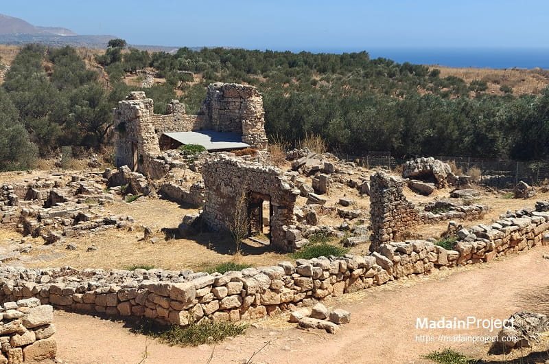
During the 12th century in the Medieval period or the later Byzantine period, a monastery dedicated to Saint John the Theologian (Agios Ioannis Theologos) was constructed on the ancient site. The monastery occupied the hilltop area where the classical city once stood. Within the monastic enclosure, several structures were constructed, which included a chapel, a two-storey block of monks’ cells and few other structures. The monastery remained in continuous operation for several centuries.
Modern Period
The monastery of St. John the Theologian remained active until 1964 CE, after which the site ceased functioning as a monastic institution.
Today the archaeological site of Aptera is maintained by the Greek Ministry of Culture through the Department of Antiquities, which oversees conservation and archaeological work.
circa 500 BCE
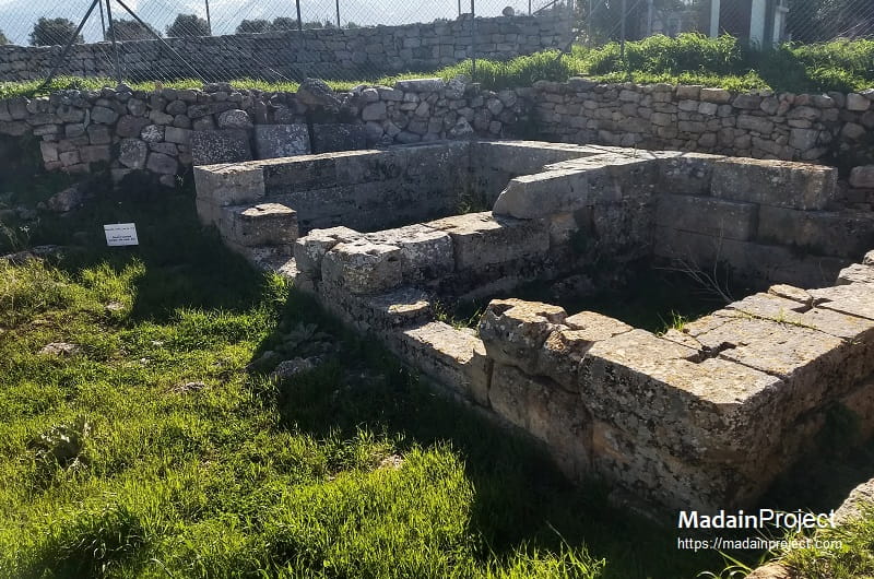
Two-Room Temple
In classical period (Classical Greece) (late 5th or early 4th century BCE), a two-room sanctuary related to the guardian gods of Aptera, Artemis and Apollo was erected over an earlier cult place (8th century BCE). The small building is built of hewn limestone blocks, bearing mortises for double-dovetail clamps. To the east it is marked out by an enclosure wall and a plain, small altar.
Research in this area has not yet been completed, but reports of past travelers attest that this area hosted the so-called “wall of inscriptions”, which was destroyed in the last decades of the 19th century CE. Proxeny decrees of the Boule (city council) and the Ekklesia of Demos (citizens’ assembly) of Aptera were incorporated in this wall (late 3rd to mid- 2nd century BCE).
The existence of this temple along with the adjacent stylobate marks the urban and political centre of ancient Aptera, i.e. the ancient agora. Its overall picture, however, has been distorted by its diachronic use until late antiquity (7th century CE) and the construction of the two-floored building complex to the north-east and its later annexes, which functioned as the glebe (‘metachi’) of the Patmos Monastery until the decade of 1960 CE.
circa 500 BCE
Stylobate
A stylobate (flat pavement for the colonnade) of a large, public, stoic building survives in the same area as the two-chambered temple, next to the stone-paved street leading to the city’s theatre.
A stoic building, or simply a stoa, was a long, covered walkway in ancient Greek architecture, featuring a row of columns (usually Doric or Ionic) on one side and a solid wall on the other. Serving as public, open-fronted porticos, they acted as social hubs, marketplaces, and shelters in, or around, public areas (agoras). The Stoic school of philosophy was named after the Stoa Poikile ("Painted Porch") in ancient Athens, where Zeno taught.
circa 300 BCE- 600 CE
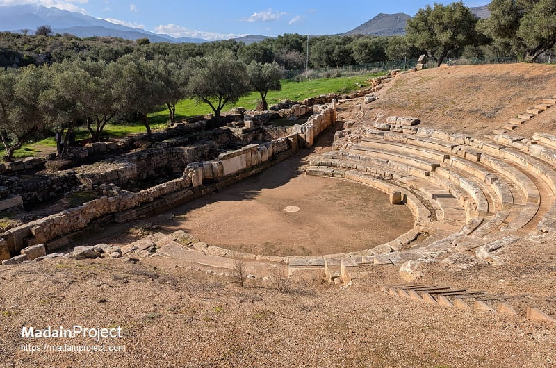
Roman Theater
The theater represents a significant archaeological exempla of the Hellenistic to Roman architectural transition. Constructed primarily from local fossiliferous limestone within a natural southern-facing declivity, the structure’s development occurred in three distinct chronological phases: the Hellenistic (3rd century BCE), First Roman (1st century CE), and Second Roman (3rd century CE). Its layout consists of a semi-circular auditorium (koilon or cavea) spanning 54.68 metres in diameter, which historically accommodated 26 rows of seats divided into four wedge-shaped sections (cunei) by five staircases. Notably, its orchestra is among the smallest of its kind, featuring a radius of only 5.45 metres and containing the remains of a thymele (altar) dedicated to Dionysus. Despite suffering extensive degradation in the 20th century CE due to the operation of a modern lime kiln that calcined much of its seating, systematic excavation and restoration projects conducted by the Ephorate of Antiquities of Chania between 2008 and 2015 CE have successfully stabilised the monument for contemporary cultural use.
circa 50 CE
Roman Baths
Aptera's bath complexes were built at about the same time as the Roman cisterns, sometime during the early Empire period. Their presence confirms 's population growth prasperty and fine social organization in Roman times. Their operation was interrupted after the earthquake of 365 CE, however, some of the rooms within the complex were occupied by pottery kilns that seem to have remained in that use until the seventh century CE. The excavation of this area is still underway.
BATH I: An inscribed architrave, dating from the first half of 1st to early 2nd century CE) revealed the name of the donor who was Athenian in descent and funded the bath's construction;
Οὐάρειος Λούκιος Λαμπάδις Ἀθ-
[ην]α[ιο]ς το βαλ[α]νείον [ἐπο]ίε[ι
The baths were supplied with water by the three-aisled cistern. The plan of the baths is divided in two parts. The eastern part includes three large rooms that are typical for this kind of structure. The hot bathing chamber still preserves the hypocaust (the undergound heating system consisting of small brick pillars topped by the marble floor) to some extent. The western part included the bathtubs, bypocausts, an apsidal hall and some auxiliary rooms.
BATH II: The second structure is somehow related to the L-shaped cistern, that it drew its water supply from there. Eight rooms are visible in the plan, an apsidal hall of impressive masonry has a pebble floor and included two bathtubs, one of which preserves its marble paneling intact.
circa 50 CE
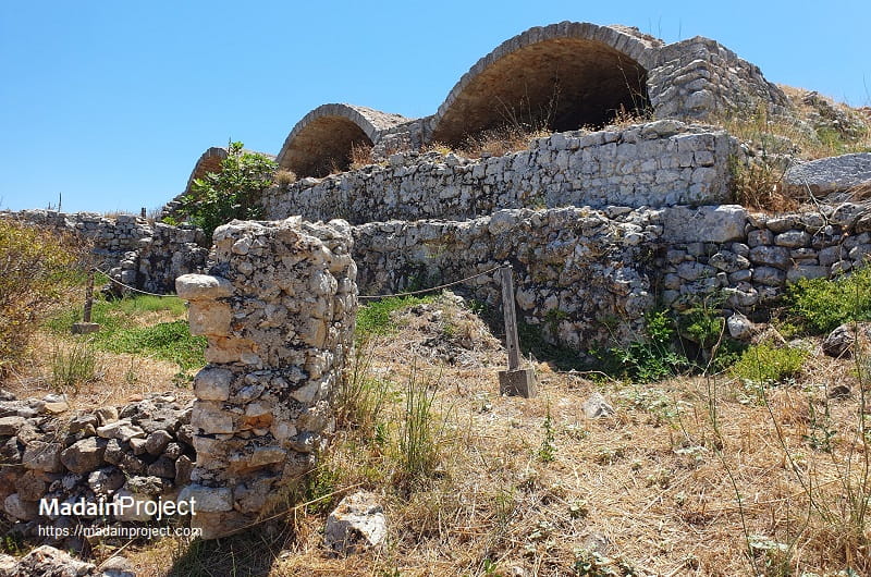
Eastern Cistern
The east cistern interior is divided into three aisles separated from each other by large pillars (internal dimensions 17x25 meters). Its capacity is estimated at 2,900 cubic meter. While the monasterial glebe (metochi) was in use. Today's access was formed by widening the ancient drainage channel. Its roof was also possibly repaired at that time.
The western, L-shaped cistern has a similar capacity (3,000 cubic meter). It measures 90 meters in total length and 9 meters in width. Its external overground part is supported by strong buttresses. Similar to the eastern cistern the largest part of the cistern is hewn in to the bedrock. However, unlike the eastern cistern this one has completly lost its roof. A complex system of conduits supplied water to a few smaller cisterns in the adjacent area and the two bath complexes situated to the north (Bath II) and north-east (Bath I).

Signup for our monthly newsletter / online magazine.
No spam, we promise.
The Madain Project is an online archive of Abrahamic History and Archaeology.
Abrahamic History & Archaeology is the study of history and archaeology with respect to the three Abrahamic Faiths without considering the religious and theological aspects. The goal of Abrahamic History is to understand how and why the religious doctrines and behaviours have evlovled and changed over time. Searching for patterns in the evolution of significant cultural events such as the development of farming, the emergence of cities, or the collapse of major civilizations for clues of why and how these have influenced the three major Abrahamic religions.
Cloud Drive -
About -
Help -
Editorial Policy -
AI Policy -
Privacy Policy -
Contact
Madain Project: Encyclopedia of Abrahamic History & Archaeology.
Copyright MadainProject 2017 - 2026.
![]()
![]()
![]()
![]()
![]()
![]()