Ancient Gournia (Γουρνιά), now a major archaeological site, was a Bronze Age Minoan town—essentially a small urban settlement where people lived, worked, and governed locally—on the island of Crete in the Aegean Sea, present day Greece. It existed roughly between 2000 and 1450 BCE as part of the wider Minoan civilization.
Ancient Gournia refers to a well-preserved Bronze Age settlement of the Minoan civilization located on the north coast of eastern Crete in the modern region of Lasithi, near the Mirabello Bay. Flourishing primarily during the Middle and Late Minoan periods (circa 2000–1450 BCE), Gournia is notable as one of the few extensively excavated Minoan towns that provides a detailed view of everyday urban life in addition to the palatial or ceremonial architecture.
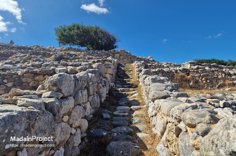
Archaeologically, the site consists of a densely built town organized around a small central court and connected by a network of narrow, stone-paved streets and stepped alleys. The settlement includes domestic houses, workshops, storage areas, and a modest “palace” or administrative complex, indicating a locally organized political and economic center integrated within the broader Minoan cultural sphere dominated by larger palatial sites such as ancient Knossos and ancient Phaistos. Material remains—such as pottery, tools, and industrial installations—suggest that the inhabitants were engaged in craft production, trade, and maritime activity connected to regional networks across the Aegean Sea.
The site was first systematically excavated between 1901 and 1904 CE by the American archaeologist Harriet Boyd Hawes under the auspices of the American Exploration Society. Her work revealed an urban settlement remarkably intact in its layout, making Gournia one of the most significant archaeological examples for reconstructing Minoan urban planning and socio-economic organization. The town appears to have been abandoned around the mid–15th century BCE, possibly in connection with widespread disruptions affecting Minoan centers following the eruption of Thera (Santorini) or subsequent Mycenaean expansion.

circa 3100 BCE- 700/800 CE

Early Minoan I–II
Gournia lies on the north coast of eastern Crete, approximately 19 kilometers east of modern Agios Nikolaos, overlooking the Gulf of Mirabello. Occupation commenced in the Early Minoan (EM) I period (circa 3100–2650 BCE), with material remains indicating dispersed domestic activity on the low hill and adjacent ridges. By EM II (circa 2650–2200 BCE), the settlement had developed into a substantial nucleated town, characterized by rectilinear domestic structures built of local schist and limestone. Ceramic assemblages of EM II date include fine gray burnished wares and mottled Vasiliki ware, linking the site to broader eastern Cretan exchange networks.
Funerary activity began in EM II/III. Burials were placed in natural rock shelters on the Sphoungaras ridge, notably at "Deposits A and B", where direct inhumations were accompanied by pottery and small stone vessels. Additional mortuary installations appeared on the north ridge (rock shelters V and VI), as well as a constructed chamber tomb (House Tomb III), which remained in use into the Middle Minoan IA period. These burial contexts demonstrate continuity of occupation and evolving mortuary architecture from communal rock-shelter interments to more formal built tombs.
Middle Minoan IA
During Middle Minoan (MM) IA (circa 2100–1925 BCE), the settlement expanded and funerary architecture became more elaborate. Five additional House Tombs (I, II, IV, VII, and VIII) were constructed on the slopes adjacent to the habitation area. These rectangular chamber tombs, built with coursed masonry and occasionally featuring partition walls, reflect increasing social differentiation and investment in lineage-based burial monuments. Ceramic evidence from these tombs includes polychrome Kamares ware, situating Gournia within the island-wide florescence of Protopalatial culture.
Middle Minoan IB–II
Substantial architectural activity occurred in MM IB (circa 1925–1875 BCE). Domestic quarters were reorganized along terraced streets, and large multi-roomed buildings were erected in the central sector. This phase of construction was destroyed during MM II (circa 1875–1700 BCE), as attested by collapse layers and burned debris across the settlement. The destruction corresponds chronologically with widespread disruptions at other Cretan centers.
Comparative stratigraphy indicates that sites such as Zakros to the east and Hagia Triada to the west experienced similar building and destruction sequences. At Hagia Triada, geological evidence associates the MM II destruction with major seismic events; although the specific cause at Gournia remains undetermined, earthquake activity is a plausible contributing factor within this regional pattern.
Middle Minoan III–Late Minoan II
Reoccupation and rebuilding in MM III (circa 1750–1600 BCE) marked the apogee of Gournia’s urban development. A centrally located palace complex was constructed on the summit of the hill, comprising a west court, magazines, domestic quarters, and administrative rooms arranged around a paved court. The settlement reached its maximum extent between MM III and Late Minoan (LM) II (circa 1750–1470 BCE), covering approximately 1.68 hectares.
At this stage, the town consisted of roughly 64 houses organized along a cobblestone street system exceeding 500 meters in total length. A central open space of approximately 500 square meters functioned as a town square, facilitating communal and economic activities. The integration of drainage channels and stepped alleyways demonstrates advanced urban planning adapted to the steep topography.
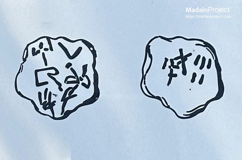
Administrative activity during LM IA–IB is attested by the discovery of Linear A tablets in the final destruction layer. All inscribed tablets were recovered from this terminal horizon, indicating that administrative records were in use at the moment of catastrophe. A Linear A clay roundel (sealing) dated to LM IA further attests to centralized control of goods and transactions within the palace economy.
The settlement was destroyed in LM IB (circa 1625–1470 BCE), part of the broader wave of destructions that affected major Minoan centers across ancient Crete. The precise cause at Gournia remains uncertain; however, the destruction coincides with the widespread LM IB horizon that followed the volcanic eruption of Thera (circa 1600 BCE) and subsequent sociopolitical upheavals.
Late Minoan III / Mycenaean Period
Following a period of reduced activity, Gournia was reoccupied in LM III (circa 1420–1075 BCE) under Mycenaean influence. Architectural modifications include the construction of a megaron-type building, reflecting mainland Greek architectural traditions associated with Mycenaean palatial culture. Ceramic assemblages of LM IIIA–B date confirm integration into the Mycenaean cultural sphere after the collapse of the Neopalatial system on Crete.
This final phase marks the transformation of Gournia from a Minoan urban center into a secondary settlement within the Mycenaean administrative network, preceding its eventual abandonment in the late second millennium BCE.
circa 1500–1450 BCE
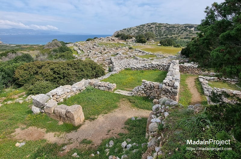
The ancient settlement of Gournia is situated on the northern coast of Crete. The main town lies approximately 150–200 meters south of a coastal ridge, which itself is located about 100 meters inland from the northern shoreline. This ridge is the location of the Sphoungaras Cemetery, one of the principal burial areas associated with the settlement. The urban center of Gournia developed around a palatial complex positioned on the central-western side of the town. To the south of the settlement lies a large public court, while to the north a trench demarcates the inhabited area from the North Cemetery of Gournia, which is located roughly 80 meters beyond the trench and between the town and the coastal ridge.
Scholars such as D. Matthey Buell and John C. McEnroe have further subdivided the settlement into a series of sectors designated by the letters A, B, C, D, E, F, H, and I. Sections E, F, and I are located on the northern side of the town but remain south of the northern trench. Sections A, B, C, and D occupy the eastern portion of the settlement, whereas Section H is situated in the southwestern area.
The funerary landscape of Gournia includes two main burial zones. The Sphoungaras cemetery makes use of natural rock shelters and cavities, which provided suitable spaces for burial without requiring the construction of elaborate tomb structures. This cemetery remained in use throughout the continuous Minoan occupation of the site. During the Early Bronze Age, inhumation was the primary method of burial. Around 1900–1800 BCE, however, a new practice emerged in which the deceased were interred within large storage jars, a method commonly referred to as pithos burial. The cemetery was first excavated by Harriet Boyd Hawes, and later investigated by Richard Seager in 1910, as well as by Jeffrey S. Soles and Costis Davaras in 1970. Excavations yielded a variety of grave goods, including complete ceramic vessels, jewelry, and ivory seals.
A second burial area, the North Cemetery, was discovered in 1901 by Harriet Boyd Hawes and her team. Here, the deceased were interred within constructed buildings rather than natural rock formations. Boyd described these as “intramural burials” and later introduced the term “house tombs” to designate this distinctive architectural form. The skeletal remains within these structures appear to have been deposited in a charnel-house manner, with bones accumulated without strict order, indicating repeated use of the tombs for multiple interments over time.
circa 1500–1450 BCE
House CF
In addition to the standard assemblage of storage, cooking, and drinking vessels, the excavation of House CF yielded several noteworthy artifacts. These include a clay roundel bearing inscriptions in Linear A (inspect) characters and a possible stone crucible. The presence of these objects suggests that the occupants of the house may have been engaged in activities related to bronze working.
circa 1500–1450 BCE
House DD
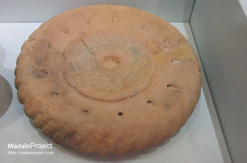
House DD (Oikia DD) at Gournia is identified most-likely as a specialized wine-making facility, distinguished by the recovery of a terracotta wine press (lenos) and vessels in room D30. Situated in the north-eastern quarter of the Neopalatial town, the structure’s primary industrial function is defined by this fixed installation, which was used for crushing grapes to extract juice for fermentation. Unlike standard domestic units, the spatial configuration of House DD was adapted to accommodate the logistical requirements of liquid processing and bulk storage, likely utilizing its lower-level chambers for the placement of large pithoi to hold the maturing vintages.
This equipment included a clay wine press discovered sitting on a stone bench and a vessel was placed in the hole in the floor under the spout to catch the juice from the crushed grapes. This appratus is a 3500 year old minoan version of the Greek Patitiri used for pressing grapes in traditional Greek villages. The presence of this dedicated viticultural equipment within a residential context underscores the high degree of household-level industrial specialization in Late Minoan IB Gournia, where individual buildings served as primary nodes for the town's agricultural economy and regional trade.
circa 1500–1450 BCE
House AC
The main entrance to the house from the road leads in to a stone paved courtyard. In the basement room 16 remains of a mud brick wall are still preserved. Similar mud-brick was used in the construction of the upper stories of the residential structures in the ancient town of Gournia. A portion of a window is preserved in the back of room 7. Among the finds discovered in this house structure were cooking pots, large jars for storage of agricultural produce, clay ritual vases, and a potter's wheel (inspect).
circa 1500–1450 BCE
House FD
The south entrance leads in to an open court with a portico on the west side. A jar with a portico on the west side. A jar was set in to the paved courtyard to catch rainfall (rain water). As in many houses at Gournia cooking pots and vessels as well as evidence of manufacturing were found in House FD. A relatively large number of other artefacts including, metal tools such as axes, chisels, swords, balance pans were also found. For a scale found by the doorway of room 18 suggests that the owner or resident of this house most likely worked and or traded in Bronze. 14 loom weights found near the south wall of room 18 suggest that an upright wooden loom once occupied the space.
circa 1500–1450 BCE
"Palace"
The so-called palace, most likely a public or administrative building, was the largest and most luxurious building in the town. It has been theorized that is was an administrative center as well as the residence of the town's political elite. The ground floor consisted ofresidential apartments, storage areas and bathing facilities, while the upper level held additional living quarters, workrooms and an archive. The large almost rectangular courtyard at the south was the center of the public life. Steps on the north side of the court, along the front of the palace, created an impressive theatrical area from which spectators could watch religious ceremonis and celebrations. A stone object in the shape of a bull's horns was found in the court where it had fallen from the roof of the palace wall. This minoan symbol, called horns of consecration is often found at shrines and palaces across the Minoan world (including Knossos and Phaistos), where it evoked the sacred nature of the building its exact meaning remains unknown.
Many of the palace finds, elaborate stone libation vases, stone lamps, a bronze double axe, pans of a scale balance, engraved seals, and pithoi jars, point to the ceremonial and commercial or administrative nature of the palace.
circa 1500–1450 BCE
House Tomb I
The "House Tomb I" is a square structure measuring approximately 4 meters on each side. It is situated on the eastern slope of the North Cemetery. The tomb was initially excavated by Harriet Boyd Hawes and was subsequently re-examined in 1971 by another archaeological team. These investigations produced a substantial assemblage of artifacts interpreted as funerary offerings.
Among the finds were two small vases, a miniature jug, and a handleless mug dating to the Middle Minoan IA period (circa 2100–1875 BCE), all recovered in situ. Additional objects included a silver kantharos, two bird’s-nest bowls, a pair of bronze tweezers, several stone vessels, seals, items of jewelry, and fragmentary sarcophagi. The latter contained the remains of at least eight skulls along with other unidentified human bones, indicating multiple interments within the tomb.
circa 1500–1450 BCE
House Tomb II
The "house tomb II" is among the best-preserved funerary structures at Gournia. In contrast to the square plan of the other house tomb at the site, this structure is rectangular in form and is composed of two rooms. It is also the only tomb at Gournia known to contain an altar. Altars are more commonly associated with the exterior spaces of Minoan tholos tombs—circular burial structures widely used for communal interments at several sites in southern Crete.
Despite their funerary function, the house tombs at Gournia were constructed using the same architectural techniques and stylistic features employed in the domestic buildings of the settlement. As a result, without the presence of the shrine or other contextual indicators, these structures may have resembled ordinary houses to outside observers.
The assemblage recovered from the tomb includes stone seals, fruit stands, three bronze tweezers, terracotta vessels, cups, jugs, pithoi, and larnakes. Fragmentary human remains were also discovered, although only a single skull was sufficiently preserved for detailed study. The arrangement and accumulation of the skeletal material suggest a secondary pattern of deposition, whereby earlier remains were moved aside after complete decomposition in order to create space for subsequent burials.
circa 1500–1450 BCE
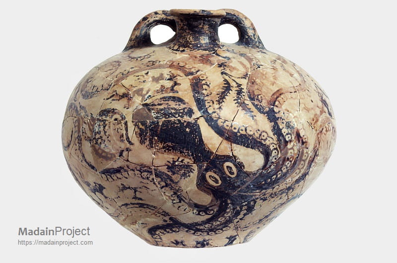
Octopus Stirrup Jar
The Octopus Stirrup Jar from Gournia, now preserved in the Heraklion Archaeological Museum, is a Late Bronze Age Minoan ceramic vessel (Late Minoan III, circa 14th–13th century BCE) characteristic of the stirrup-jar type used for storing and transporting liquids such as oil. The jar has a globular body with a flat base and a shoulder supporting two vertical loop handles attached to a false spout, while the true pouring spout emerges between them—an arrangement typical of this functional form. Made of fine buff clay and decorated in dark brown to black slip, the vessel is covered with a naturalistic marine-style composition dominated by a large octopus whose rounded head occupies the central field while elongated tentacles, marked by rows of circular suction cups, extend fluidly across the curved surface.
The limbs coil dynamically around the body, adapting to the vessel’s shape and filling the available space, while smaller marine fillers such as fish and abstract motifs occupy the remaining areas. The decoration exemplifies the Minoan fascination with marine life and the integration of organic movement with ceramic form. Visible join lines indicate modern reconstruction from fragments, but the painted imagery remains largely intact, making the vessel a representative example of Late Minoan marine-style pottery and the artistic traditions of eastern Crete.
Signup for our monthly newsletter / online magazine.
No spam, we promise.
The Madain Project is an online archive of Abrahamic History and Archaeology.
Abrahamic History & Archaeology is the study of history and archaeology with respect to the three Abrahamic Faiths without considering the religious and theological aspects. The goal of Abrahamic History is to understand how and why the religious doctrines and behaviours have evlovled and changed over time. Searching for patterns in the evolution of significant cultural events such as the development of farming, the emergence of cities, or the collapse of major civilizations for clues of why and how these have influenced the three major Abrahamic religions.
Cloud Drive -
About -
Help -
Editorial Policy -
AI Policy -
Privacy Policy -
Contact
Madain Project: Encyclopedia of Abrahamic History & Archaeology.
Copyright MadainProject 2017 - 2026.
![]()
![]()
![]()
![]()
![]()
![]()