Ancient Tylissus or Tylissos (Greek: Τύλισσος), or Tylisus or Tylisos (Τύλισος), was a town of ancient Crete. Tylissos functioned as an autonomous polis in north-central Crete, situated west of ancient Knossos. Epigraphic documentation of the fifth century BCE records Tylissos in formal treaties and territorial agreements, demonstrating its recognized political status within the network of Cretan city-states. These inscriptions attest to defined borders and regulated interstate relations, reflecting the institutional structures characteristic of Classical Cretan poleis.
Tylissos was first systematically excavated between 1909 and 1913 CE under the direction of Joseph Hadzidakis, whose work brought to light three substantial Late Minoan period building complexes conventionally designated Buildings A, B, and C. Hadzidakis’ excavations established the architectural character of the settlement and recovered significant assemblages of bronze vessels, storage pithoi, and inscribed materials. Subsequent campaigns conducted between 1953 CE and 1955 CE by Nikolaos Platon refined the stratigraphic sequence and clarified the chronological development of the principal structures, while further investigations in 1971 CE by A. Kanta contributed additional data concerning Late Minoan occupation phases and material culture.
Archaeological evidence demonstrates continuous or recurrent occupation from the Early Minoan II period (circa 2500–2300 BCE) through Late Minoan IIIA (circa 1400–1300 BCE). The principal architectural remains belong to the Neopalatial period, particularly Late Minoan I (circa 1600–1450 BCE), when the settlement attained its greatest architectural elaboration. The built environment comprises multi-room residential complexes constructed in ashlar and rubble masonry, internal courts, storage magazines, and specialized installations. Among the hydraulic features identified are a substantial plastered cistern and a constructed aqueduct system employing terracotta (clay) pipes designed to channel water into the settlement, indicating planned water management and technical competence consistent with contemporary Minoan centers.
A peak sanctuary associated with the settlement, excavated in 1963 CE by Stylianos Alexiou, remained in use at least until Late Minoan IA (circa 1600–1500 BCE). The sanctuary yielded votive assemblages characteristic of Minoan highland cult sites, including clay anthropomorphic and zoomorphic figurines and stone “horns of consecration”, emblematic symbols of Minoan religious practice. The presence of such material confirms the integration of Tylissos into the broader religious landscape of Bronze Age Crete and suggests ritual activity connected to both the settlement and its surrounding territory.
Portable finds from the settlement proper include a large storage pithos bearing Linear A inscriptions, attesting to administrative practices during the Neopalatial period. The inscribed vessel, together with additional sealings and storage installations, indicates the management of agricultural surplus and participation in regional exchange networks. The combined architectural, hydraulic, epigraphic, and votive evidence situates Tylissos among the principal secondary centers of north-central Crete during the Middle and Late Bronze Age.

circa 2500 BCE- 700/800 CE

Prepalatial and Early Minoan Occupation
The site of ancient Tylissos, located on the eastern slopes of Mount Psiloritis in the modern Heraklion regional unit of Crete, was first occupied in the Early Minoan II period, (Early Minoan II – Middle Minoan II, circa 2500–1700 BCE). Evidence from scattered surface finds indicates habitation by at least circa 2500 BCE, with material culture including pottery and small figurines consistent with Early Minoan domestic settlement. The settlement continued through Middle Minoan II, reflecting gradual growth but without evidence for major monumental architecture at this stage. Linear A inscriptions characteristic of the Minoan palace culture had not yet been documented in these earlier phases.
Neopalatial and Late Minoan I Periods
In the Late Minoan I period (circa 1650–1450 BCE), Tylissos reached its apex of development within the broader Neopalatial phase of Minoan Crete. Archaeological excavations have identified at least three monumental residential complexes—designated House (or Megaron) A, B, and C—constructed with multi-room layouts, central courtyards, and complex circulation patterns that parallel architectural elements at contemporary palatial sites on Crete such as Knossos. House A, the largest, featured a monumental entrance, storage magazines, and residential suites; House C included evidence of sophisticated water management systems with aqueduct clay pipes and drainage infrastructure.
Finds from this period include large storage pithoi, Linear A inscribed tablets, small fresco fragments stylistically akin to Knossian iconography, and bronze artifacts including cauldrons and figurines, suggesting Tylissos participated in the elite exchange networks and artisanal production typical of major Minoan centers. The strategic location of Tylissos on the inland route linking Knossos with western Cretan sites and the mountain hinterland of Psiloritis likely contributed to its economic and administrative significance within the island’s inter-regional network.
Destruction and Post-Palatial Period
Around 1450 BCE, coinciding with the widespread destruction of many Neopalatial centers across Crete, the principal monumental complexes at Tylissos were burned and reduced to rubble. This event, synchronous with evidence for seismic activity and socio-political disruption in the mid-15th century BCE, marks the end of the site’s initial florescence phase. Subsequent stratigraphic layers indicate that the settlement was reoccupied in the Late Minoan IIIA period (circa 1400–1200 BCE), though the scale of architectural investment and artifact assemblages suggests diminished regional prominence compared to its Neopalatial peak. During this Post-Palatial period, occupation is evidenced by reconstructed domestic structures, continuing craft activity, and the reutilization of older architectural foundations, but without the extensive palatial planning seen earlier.
Greek Historical Period
In the subsequent historical era, Tylissos appears in classical Greek contexts as an autonomous polis in Crete. Epigraphic evidence, including treaties from the fifth century BCE, documents diplomatic and territorial agreements between Tylissos and neighboring centers such as Knossos, indicating recognized political agency within the Classical period Cretan landscape. Coinage attributed to the city features indigenous iconography, including a youth holding an ibex head and bow motif, reflecting localized civic identity and participation in the Hellenic monetary sphere. The town’s independence persisted into the Hellenistic period until Roman annexation of Crete in 67 BCE, after which Tylissos, like other Cretan city-states, was integrated into the provincial structures of the Roman Republic and Empire.
Late Antiquity to Modern Period
Following the Roman period, Tylissos continued as a settlement through Byzantine, Venetian, and Ottoman eras, though its ancient name and archaeological remains were largely obscured until modern rediscovery.
During the Byzantine period (first phase 4th–9th centuries CE; second phase 961–1204 CE following the reconquest of Crete by Nikephoros II Phokas), the settlement appears to have persisted as a rural habitation within the administrative framework of central Crete, but no major ecclesiastical basilicas, fortifications, or securely dated public buildings have been documented on the excavated Minoan remains. Evidence derives primarily from scattered architectural spolia, ceramics, and references to the later village occupying the broader area rather than the Bronze Age core.
Under Venetian rule (1204–1669 CE), Crete formed the Regno di Candia within the maritime empire of Venice. Archival sources mention settlements in the region of modern Tylissos in fiscal and land records, indicating agricultural activity and integration into the feudal landholding system administered from Candia (modern Heraklion). However, the Minoan architectural remains were not a focus of construction or monumental reuse comparable to sites such as Knossos. The continuity here is primarily that of rural occupation rather than urban prominence.
During the Ottoman period (1669–1898 CE), following the fall of Candia in 1669, the area remained an inhabited village within the Ottoman administrative structure of Crete. Documentary evidence is limited to tax registers and later travel accounts referencing the village rather than the ancient ruins. There is no evidence of significant Ottoman architectural intervention at the Bronze Age site itself.
The site was first systematically excavated by Joseph Hadzidakis between 1909 and 1913, after accidental finds of large bronze cauldrons attracted scholarly attention. Subsequent campaigns, including those by Nicholas Platon in the 1950s and A. Kanta in the 1970s, clarified the Minoan urban layout and architectural phases, leading to ongoing restoration efforts and interpretation of the site within the broader framework of Aegean Bronze Age archaeology
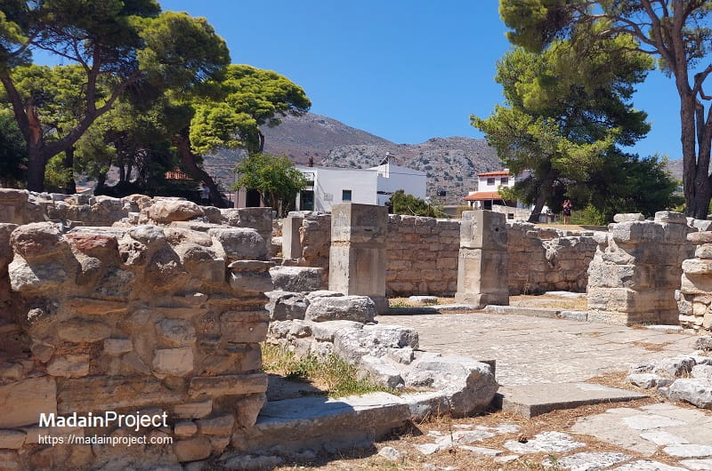
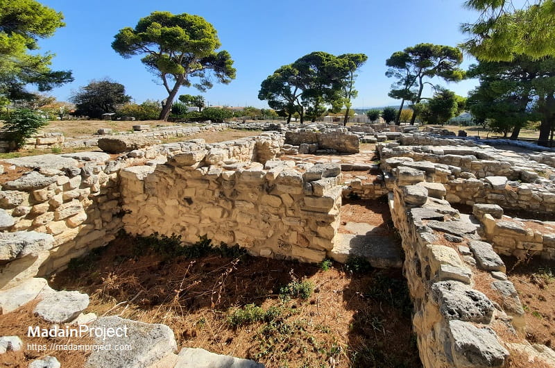
House A
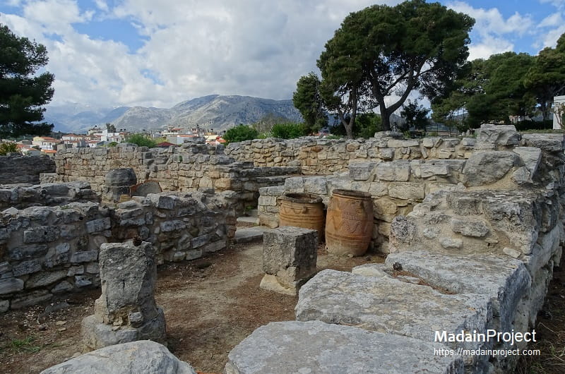
House A extends between Houses B and C, which form the core of the site. It was a monumental two-storey building covering an area of approx. 630 square meters and consisting of 24 rooms. The layout of the rooms and the finds show that it was divided into two operating areas; the north with storage facilities and the south with domestic and cult quarters.
The entrance is located in the east and consists of an outdoor portico with triple door openings. It leads to room 15 where a plethora of conical cups were discovered as well as a bronze axe, a sword pommel and a number of pithoi. To the north east side are two large storage areas (rooms 16 and 17) where the hefty pillars supporting the superstructure are preserved. The staircases which lead to the upper floor are in the west section. The south corridor provides access to the central room (room 6) featuring a portico and a light well at the west.
Room 11 at the north-section is interpreted as a lustral basin, while rooms 1 and 2 in the south were storage facilities. Rooms 3, 4 and 5 appear to have had cultic use; room 3, which is interpreted as a pillar crypt, yielded a bronze figurine of a worshipper, clay and stone vessels, votive axes, fragments of wall paintings and numerous animal bones, among which are those of a small bull. In room 4 among the finds were ccases containing pigments and sealings. In room 13 a bronze ox-hide, ingot was discovered along with Linear A tablets, sealings, small bronze objects, tools and gold foil. Four enormous bronze cauldrons were stored possibly in room 5.
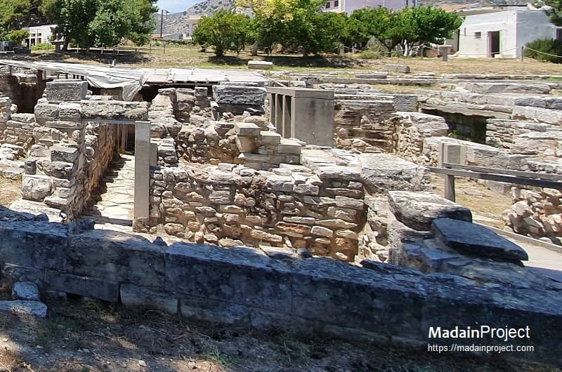
House B
The so-called House B, measuring approx. 22 x 15 meters is located in the south west section of the archaeological site. It has a rectangular shape with sublte indentations at the northern and southern facades, as well as paved floors in several areas. The entrance is situated at the east, while the double staircase leading to the upper floor lies to the north east. Corridors b and c provide access to the south and west suits of rooms. A particularly interesting feature in room 6 (in the north west corner) is a stone-built cabinet of sorts, containing Neopalatial pottery. A steatite offering table and parts of a second one were found in the same room. Fragments of wall paintings, probably fallen from the upper floor, were scattered in the entire area of the building and especially in room 12.
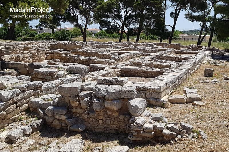
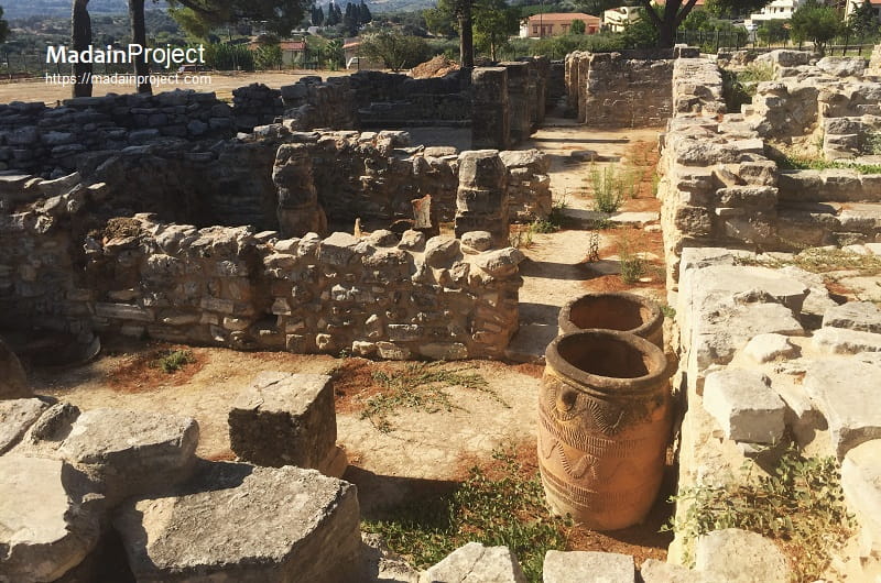
House C
The house C, situated immediately to the north of the "house A", covering approx. 422 square meters, provides a typical example of Neopalatial architecture. The Xeste facade carries recesses and protrusions as well as incised mason's marks. An important element of House C, as much as of House A, is the well-preserved clay plasters which covered the walls. They can be seen in rooms 5, 6, and 12 and also in the corridors B and C. Three staircases attest to an organized system of rooms with different fuctions. The entrance of the house is located in the east and leads into a square vestibule and a long corridor (corridor A-A), with seven doors, identical in shape and size, provided access to areas of the building with different functions. Room 2 presumably a domestic shrine, with internal storage (room 3) is just south of the entrance. A door of one side of Room 2 opens into an area with drains, beneath staicase Z. Another door gives access to the corridor surrounding the so-called main chamber of the house (room 5). The other doors to the south lead to storage areas, with the exception of theone that gives way onto corridor B-B, which served the private apartments, as well as adjacent corridors. One of these corridors leads to room 12 which was originally used as lustral basin. The main hall system has a pier-and-door system (polythyron) a corridor and a skylight (room 15). Fragments of wall paintings with floral motifs were also discovered in room 7.
During the postpalatial period a mansion of the type of Mycenaean megaron was installed on the ruins of the House C. A large plastered cistern, which was built on the east side of the Mycenaean megaron contained clay figurines, possibly related to a cult focusing on water.
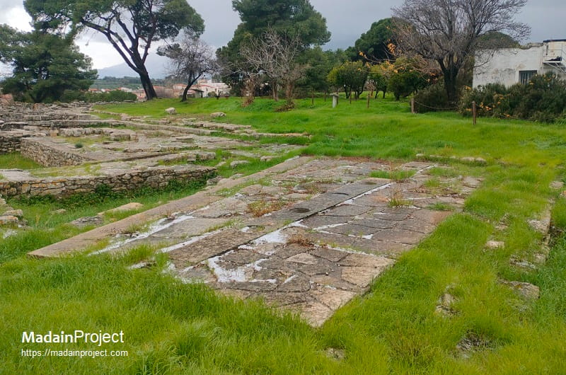
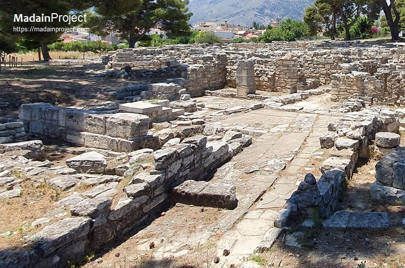
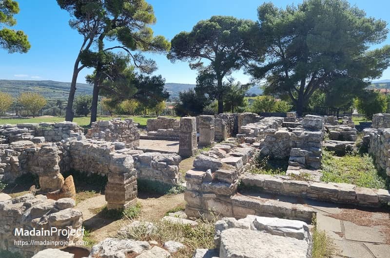
Post Palatial Portico Pavement
The architectural landscape of Postpalatial Tylissos is defined by a significant reorientation of the site’s urban fabric following the terminal destruction of the Neopalatial mansions around 1450 BCE. Central to this transformation is the construction of a five-columned portico, or stoa, which stands as a rare example of freestanding public architecture from the Late Minoan III period. This structure, situated to the north of the ruins of House C, was integrated into a wider complex that included a large circular cistern and a paved open-air court known as the "Square of the Altar." The portico’s presence indicates a shift from the labyrinthine, inward-facing domesticity of the earlier palaces toward more structured, communal spaces that reflect the administrative and social influences of the Mycenaean mainland.
The pavement associated with this portico serves as a critical diagnostic feature for dating and identifying the site's late-stage occupancy. Unlike the polychrome and gypsum-heavy floors of the preceding period, the Postpalatial pavement consists of heavy limestone flagstones and rubble paving that emphasizes durability and utilitarian access. This paved expanse facilitated movement between the newly constructed Megaron-style dwelling and the religious focal points of the settlement. The deliberate surfacing of the area suggests that, despite the collapse of the central palatial system, Tylissos maintained a high degree of civic organization and communal investment in its public infrastructure during the 14th and 13th centuries BCE.
Furthermore, the spatial relationship between the portico and its pavement highlights a sophisticated understanding of drainage and pedestrian flow within the Postpalatial settlement. The pavement was engineered to slope slightly away from the column bases of the stoa, directing rainwater toward the site’s sophisticated hydraulic systems, including the nearby stone-lined reservoir. This integration of a monumental covered walkway with a formal paved court suggests that the area functioned as a primary hub for socio-religious activities. Consequently, the Postpalatial portico and pavement at Tylissos represent a transitional architectural idiom that blended traditional Minoan masonry techniques with the emerging socio-political requirements of the Mycenaeanized Aegean.
Signup for our monthly newsletter / online magazine.
No spam, we promise.
The Madain Project is an online archive of Abrahamic History and Archaeology.
Abrahamic History & Archaeology is the study of history and archaeology with respect to the three Abrahamic Faiths without considering the religious and theological aspects. The goal of Abrahamic History is to understand how and why the religious doctrines and behaviours have evlovled and changed over time. Searching for patterns in the evolution of significant cultural events such as the development of farming, the emergence of cities, or the collapse of major civilizations for clues of why and how these have influenced the three major Abrahamic religions.
Cloud Drive -
About -
Help -
Editorial Policy -
AI Policy -
Privacy Policy -
Contact
Madain Project: Encyclopedia of Abrahamic History & Archaeology.
Copyright MadainProject 2017 - 2026.
![]()
![]()
![]()
![]()
![]()
![]()