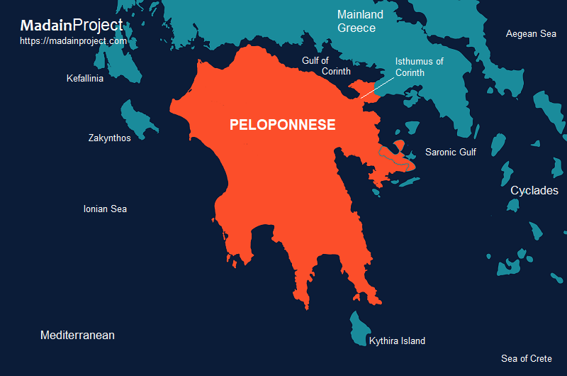
The Peloponnese (Peloponnesus) is a peninsula and geographic region in Southern Greece and the southernmost part of the Balkans. Historically known as the Morea, it is connected to central Greece via the Isthmus of Corinth, which serves as a land bridge separating the Gulf of Corinth from the Saronic Gulf.
The geography of the Peloponnese is defined by its status as a rugged, mountainous peninsula connected to the Greek mainland via the Isthmus of Corinth, though functionally transformed into an island by the nineteenth-century CE construction of the Corinth Canal. Its interior is dominated by the Arcadian plateau and the Taygetus and Parnon mountain ranges, which give rise to fertile alluvial plains such as those of Argolis, Messenia, and Elis. This highly fragmented topography, characterized by deep-cut limestone massifs and a serrated coastline with four major southward-projecting peninsulas, historically dictated the development of isolated, autonomous city-states and localized agricultural economies.
In Greek mythology, the region serves as the primary topographical setting for the Heroic Age, deriving its etymology from Pelops, the Phrygian hero who established a dynastic hegemony after his victory at Olympia. The peninsula functions as the locus for the foundational myths of the House of Atreus, centering on the palatial complexes of Mycenae and Sparta, and provides the landscape for the majority of the Twelve Labors of Heracles, specifically within the Argolid and Arcadia. These narratives utilize the region’s specific physical features—such as the caves of Mount Kyllini or the marshes of Lerna—to anchor divine and heroic intervention within a tangible, persistent geographic reality.
circa 40,000 BCE- Present

The history of the Peloponnese, a major peninsula in southern Greece connected to the mainland by the Isthmus of Corinth, spans from prehistoric settlement to its incorporation into modern Greece, and reflects broader patterns of Aegean and Mediterranean development. In the Bronze Age, the region was a core center of the Mycenaean civilization (circa 1600–1100 BCE), with major palatial sites such as Mycenae, Tiryns, and Pylos. These centers were characterized by hierarchical political organization, monumental architecture, and participation in extensive trade networks. The Linear B tablets recovered from Pylos provide critical evidence of bureaucratic administration and economic control. The collapse of the Mycenaean palatial system around the late twelfth century BCE, often associated with wider disruptions in the eastern Mediterranean, ushered in a period of decentralization and population decline conventionally termed the Greek “Dark Age”.
During the subsequent Archaic period / Archaic Greece (circa 800–500 BCE), the Peloponnese witnessed the emergence and consolidation of the polis (city-state) as the dominant political form. Among these, Sparta in Laconia developed a distinctive militarized and oligarchic system, underpinned by the subjugation of the helot population, while Corinth became a major commercial and colonial power due to its strategic location on the isthmus. Argos also emerged as a significant regional rival, particularly in the early Archaic period. This era saw the codification of laws, the expansion of Greek colonization, and the formation of interstate alliances. Sparta’s leadership of the Peloponnesian League established a durable hegemonic structure in the region, though it relied more on bilateral alliances than on centralized administration.
The Classical period / Classical Greece (circa 500–323 BCE) placed the Peloponnese at the center of Greek interstate conflict and political transformation. Spartan leadership was crucial during the Persian Wars (early fifth century BCE), particularly at the Battle of Thermopylae and in subsequent land campaigns. However, the protracted conflict between Athens and Sparta during the Peloponnesian War (431–404 BCE) marked a turning point. Sparta ultimately defeated Athens, temporarily establishing hegemony over much of the Greek world. Yet Spartan dominance proved short-lived, as internal weaknesses and external challenges culminated in its decisive defeat by Thebes at the Battle of Leuctra in 371 BCE. This event undermined Spartan control over Messenia (ancient Messene) and significantly altered the balance of power within the Peloponnese, leading to the rise of federal states such as the Arcadian League.
In the Hellenistic period (323–146 BCE), following the conquests of Alexander the Great, the Peloponnese became entangled in the power struggles of successor kingdoms, although it retained a degree of local autonomy through leagues and federations. The Achaean League, in particular, emerged as a significant political force, promoting a form of federal governance that integrated multiple city-states under shared institutions. This period was marked by intermittent conflict, shifting alliances, and attempts to resist external domination, notably from Macedon. Despite these efforts, the growing influence of Rome in Greek affairs gradually curtailed Peloponnesian independence.
The Roman conquest of Greece in the mid-second century BCE (late Republic period), culminating in the destruction of Corinth in 146 BCE, marked the incorporation of the Peloponnese into the Roman provincial system. Under Roman rule, the region experienced relative stability and integration into imperial economic and administrative networks during the empire period. Cities such as Corinth were rebuilt and flourished as commercial hubs, while others adapted to new political realities. Cultural continuity remained strong, with Greek language and traditions persisting alongside Roman governance. The later Roman and early Byzantine periods saw administrative reorganization and the spread of Christianity, transforming the religious and social landscape of the region.
During the medieval period, the Peloponnese—known as the Morea—underwent significant demographic and political changes. Following the fragmentation of Byzantine authority after the Fourth Crusade in 1204 CE, parts of the peninsula came under the control of Frankish crusaders, most notably in the Principality of Achaea. Byzantine forces gradually reasserted control in the later Middle Ages, particularly through the Despotate of the Morea, which became a center of late Byzantine culture and administration. However, the expansion of the Ottoman Empire in the fifteenth century CE led to the eventual conquest of the region, integrating it into Ottoman provincial structures.
Under Ottoman rule (circa fifteenth–early nineteenth centuries CE), the Peloponnese experienced both continuity and transformation in its agrarian economy and social organization. Periodic Venetian occupations, especially in the late seventeenth and early eighteenth centuries CE, introduced administrative reforms and infrastructural changes, but these were largely reversed upon Ottoman reconquest. The region played a pivotal role in the outbreak of the Greek War of Independence in 1821 CE, serving as an early hub of revolutionary activity. Key events, including the capture of Tripolitsa, underscored the strategic importance of the Peloponnese in the struggle against Ottoman rule.
Following the successful establishment of an independent Greek state in the 1830s CE, the Peloponnese was integrated into the new national framework. The nineteenth and twentieth centuries CE saw processes of state-building, economic modernization, and demographic change, including urbanization and emigration. While no longer the political heart of Greece, the region retained historical and cultural significance, shaped by its central role in earlier periods. Today, the Peloponnese stands as a region where successive layers of prehistoric, classical, medieval, and modern history intersect, offering a microcosm of the broader historical trajectories of Greece and the eastern Mediterranean.
circa 650 BCE- Present

Bassae
The archaeological site of Bassae, situated at an elevation of 1,130 meters on a rugged terrace of Mount Kotylion in southwestern Arcadia, is defined by the Temple of Apollo Epicurius, a pivotal monument of the late fifth century BCE (circa 420–400 BCE). Attributed by Pausanias to the architect Ictinus, the structure represents a highly idiosyncratic synthesis of the three primary Greek architectural orders: its peripteral exterior is Doric, the cella features engaged Ionic columns, and it contains the earliest documented use of a Corinthian capital in the Greek world. Diverging from standard Hellenic alignment, the temple is oriented north-south rather than east-west, likely to accommodate the steep topography or to reference an earlier cultic orientation. The interior was originally distinguished by a continuous Ionic frieze depicting the Centauromachy and Amazonomachy, reflecting a transition toward the heightened spatial complexity and emotional dynamism characteristic of the burgeoning Late Classical style.
circa 5000 BCE– 1858 CE

Corinth
Signup for our monthly newsletter / online magazine.
No spam, we promise.
The Madain Project is an online archive of Abrahamic History and Archaeology.
Abrahamic History & Archaeology is the study of history and archaeology with respect to the three Abrahamic Faiths without considering the religious and theological aspects. The goal of Abrahamic History is to understand how and why the religious doctrines and behaviours have evlovled and changed over time. Searching for patterns in the evolution of significant cultural events such as the development of farming, the emergence of cities, or the collapse of major civilizations for clues of why and how these have influenced the three major Abrahamic religions.
Cloud Drive -
About -
Help -
Editorial Policy -
AI Policy -
Privacy Policy -
Contact
Madain Project: Encyclopedia of Abrahamic History & Archaeology.
Copyright MadainProject 2017 - 2026.
![]()
![]()
![]()
![]()
![]()
![]()