Ancient Jerash (جرش), now a major archaeological site, was an important city in northern Jordan. Jerash is the site of the ruins of the Greco-Roman city of Gerasa, also referred to as Antioch on the Golden River. Ancient Greek inscriptions from the city support that the city was founded by Alexander the Great and his general Perdiccas, who allegedly settled aged Macedonian soldiers there during the spring of 331 BCE. After the Roman conquest in 63 BCE, Jerash and the land surrounding it were annexed to the Roman province of Syria Palestina (Syria), and later joined the Decapolis league of cities. The historian Josephus mentions the city as being principally inhabited by Syrians, and also having a small Jewish community.
The earliest evidence of settlement in Jerash is in a Neolithic site known as Tal Abu Sowan, where rare human remains dating to around 7500 BCE were uncovered. Jerash flourished during the Greek, Hellenistic, Roman, and Byzantine periods until the mid-eighth century CE, when the 749 CE Galilee earthquake destroyed large parts of it, while subsequent earthquakes contributed to additional destruction.
In the year 1120 CE, Zahir ad-Din Toghtekin, atabeg of Damascus ordered a garrison of forty men to build up a fort in an unknown site of the ruins of the ancient city. It was captured in 1121 CE by Baldwin II, King of Jerusalem, and utterly destroyed. Then, the Crusaders immediately abandoned Jerash and withdrew to Sakib (Seecip); the eastern border of the settlement. erash was then deserted until it reappeared in the historical record at the beginning of Ottoman rule in the area during the early 16th century CE.

circa 7500 BCE– modern period
The history of Jerash, known in antiquity as Gerasa, spans an extensive chronological spectrum from the Neolithic period to the Early Islamic era, making it a critical site for the study of urban development in the southern Levant. Archaeological evidence indicates human occupation of the fertile Jerash Valley as early as the Neolithic (c. 7500–5500 BCE) and Bronze Ages, though continuous urbanism likely began with a Hellenistic foundation in the late 2nd century BCE. The city's zenith occurred during the Roman period following its integration into the Roman province of Syria by Pompey in 63 BCE and subsequent inclusion in the Decapolis league of cities. This era of stability and prosperity (Pax Romana) facilitated extensive monumental construction, including the Hadrian's Arch, the Temple of Artemis, and the iconic colonnaded Cardo Maximus, transforming Gerasa into a quintessential Greco-Roman provincial city. The city's prominence continued through the Byzantine period, during which it became an important ecclesiastical center with numerous churches, before experiencing a gradual decline and partial abandonment following the devastating earthquake of 749 CE.
circa 220-749 CE

The archaeological site of ancient Gerasa, located in modern-day Jerash, Jordan, comprises one of the largest and best-preserved examples of a provincial Greco-Roman city in the Near East. This extensive complex is particularly significant for demonstrating the remarkable continuity and superimposition of urban development across the Neolithic, Hellenistic, Roman, Byzantine, and Early Islamic periods. Buried in sand for centuries and systematically excavated since the 1920s, the site's preservation is exceptional, particularly the monumental core on the west bank of the Wadi Jerash, which remained largely unoccupied after the devastating earthquake of 749 CE.
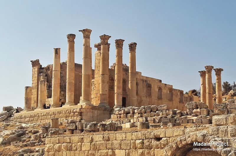
Key features include a highly organized orthogonal street plan (evident in the still-paved, column-lined Cardo Maximus), the unique Oval Plaza, major sanctuaries dedicated to Zeus and Artemis, two Roman theaters (South and North), large public bath complexes, and numerous early Byzantine churches adorned with elaborate mosaics. The material culture recovered from these ruins offers invaluable insights into the daily life, civic administration, and cultural amalgamation of a prominent Decapolis city that thrived as a hub of trade and Hellenistic culture on the eastern frontier of the Roman Empire.

Signup for our monthly newsletter / online magazine.
No spam, we promise.
The Madain Project is an online archive of Abrahamic History and Archaeology.
Abrahamic History & Archaeology is the study of history and archaeology with respect to the three Abrahamic Faiths without considering the religious and theological aspects. The goal of Abrahamic History is to understand how and why the religious doctrines and behaviours have evlovled and changed over time. Searching for patterns in the evolution of significant cultural events such as the development of farming, the emergence of cities, or the collapse of major civilizations for clues of why and how these have influenced the three major Abrahamic religions.
Cloud Drive -
About -
Help -
Editorial Policy -
AI Policy -
Privacy Policy -
Contact
Madain Project: Encyclopedia of Abrahamic History & Archaeology.
Copyright MadainProject 2017 - 2026.
![]()
![]()
![]()
![]()
![]()
![]()