The so-called Temple of the Mahlab al-Naqa refers to a monumental cultic and ritual complex within the al-Khuraybah archaeological zone of al-Ula, north-western Saudi Arabia. The structure represents one of the principal Lihyanite religious edifices of the mid–first millennium BCE, dated broadly to the 6th century BCE on the basis of architectural typology, associated inscriptions, and ceramic assemblages. The designation “Temple of the Mahlab al-Naqa” arises from the proximity of the building to the large rock-hewn basin known locally as Mahlab al-Naqa—literally “the milking bowl of the she-camel”—which is interpreted archaeologically as an integral element of the sanctuary’s ritual installations.
The temple itself forms part of a larger sacred precinct that once served as a focal point for the religious life of the Kingdom of Lihyan, whose capital was situated at al-Khuraybah. Excavations and surface surveys indicate that the temple complex functioned as a locus of cultic activity dedicated to one of the principal Lihyanite deities, possibly Dhu-Ghābah, whose name appears in inscriptions from the same area. Its construction reflects the consolidation of Lihyanite statehood and the institutionalization of formal religious architecture in north-west Arabia. The sanctuary thus provides a key reference for understanding the intersection of religion, political authority, and monumentality in the pre-Nabataean Arabian oases.
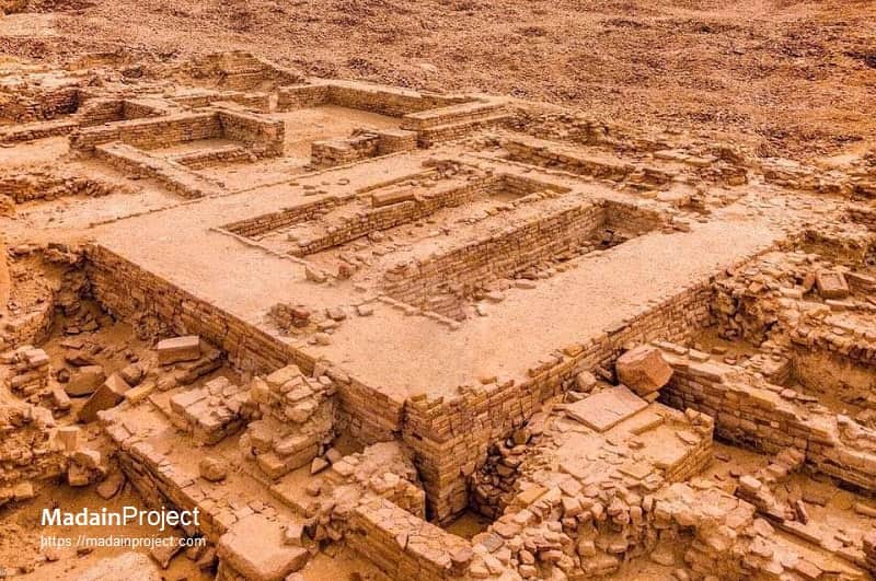
The architectural remains of a large rectangular stone-built structure at the al-Khuraybah site in the al-Ula oasis, in modern north-western Saudi Arabia. This complex is identified archaeologically as part of the Lihyanite temple precinct, often associated with the so-called Temple of Mahlab al-Naqa, dating to the mid–first millennium BCE.
In architectural typology, the temple belongs to the class of rectangular sanctuary complexes with axial subdivisions known across the north-Arabian oases between the 7th and 3rd centuries BCE. Its design may reflect a combination of local building traditions and influences from North-West Semitic or Mesopotamian temple plans, adapted to the stone-working techniques of the Lihyanite masons. The degree of preservation makes this one of the best-documented examples of pre-Nabataean monumental religious architecture in the Arabian Peninsula.
circa 600 BCE
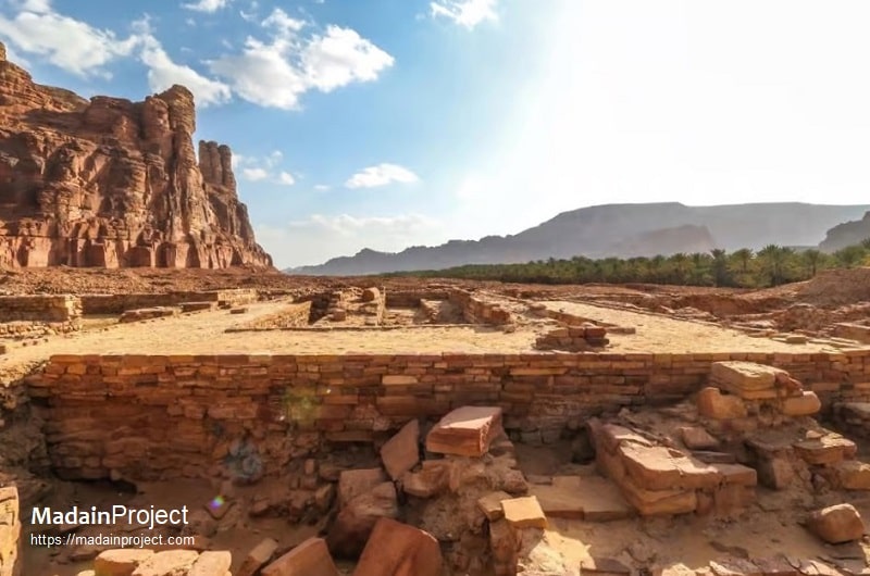
The structure is built from finely dressed sandstone blocks arranged in horizontal courses, set upon a series of well-defined foundations that reveal the substructure of an ancient monumental building. The walls outline a rectangular ground plan subdivided into several chambers or courtyards. The architectural arrangement—consisting of parallel walls forming elongated rectangular rooms or porticoes—suggests a temple or cultic building rather than a domestic or administrative one. The layout is characteristic of Lihyanite sanctuary architecture, which combines formal axial symmetry with multiple internal compartments possibly used for ritual storage, offerings, or priestly functions.
At the forefront of the image, the lower courses of masonry indicate terracing or stepped foundation work, likely compensating for uneven bedrock. The careful alignment and tight jointing of the blocks, with squared corners and occasional headers, indicate a construction technique employing ashlar masonry, a hallmark of late Dadanite–early Lihyanite craftsmanship. The thickness of the surviving walls, considerably greater than that of ordinary dwellings, reinforces its classification as a monumental public or religious edifice.
No standing superstructure remains, but the preserved foundations define both the temple platform and the base of internal cella-like rooms. The open central space may have served as a courtyard or forecourt, possibly accommodating ritual gatherings or processional movement. Archaeological parallels from the site suggest that this structure was directly linked to the nearby Mahlab al-Naqa basin, a large rock-hewn ritual installation interpreted as part of the same cultic complex.
The surrounding stratigraphy—visible in the exposed sections of the image—shows a matrix of sandstone rubble and wind-deposited sediments, indicating phases of collapse and burial following the temple’s abandonment. The absence of later structural intrusion in the visible layers supports the assessment that the site was deserted before the major Nabataean expansion into the region.


Signup for our monthly newsletter / online magazine.
No spam, we promise.
The Madain Project is an online archive of Abrahamic History and Archaeology.
Abrahamic History & Archaeology is the study of history and archaeology with respect to the three Abrahamic Faiths without considering the religious and theological aspects. The goal of Abrahamic History is to understand how and why the religious doctrines and behaviours have evlovled and changed over time. Searching for patterns in the evolution of significant cultural events such as the development of farming, the emergence of cities, or the collapse of major civilizations for clues of why and how these have influenced the three major Abrahamic religions.
Cloud Drive -
About -
Help -
Editorial Policy -
AI Policy -
Privacy Policy -
Contact
Madain Project: Encyclopedia of Abrahamic History & Archaeology.
Copyright MadainProject 2017 - 2026.
![]()
![]()
![]()
![]()
![]()
![]()