The Mada'en Saleh (مدائن صالح), also known as al-Hijr I (ٱلْحِجْر), is located amid a series of interlocking mountains and rocky cliffs and surrounded by a ring of sandy mountains. al-Hijr is thought to have been mentioned in the Holy Qur'an, described as the home of the Thamud. Located today in al-Ula governorate a subdivision of al-Madinah al-Munawarah Province of present day Saudi Arabia, the Mada’in Saleh (“the cities of Salih”) are the remains of the once wealthy and powerful Nabataean kingdom.
Madain Saleh is considered to be the most important settlement of the Nabataeans, second only to Petra. Its most significant cultural role dates back to the first two centuries BCE and first century CE, i.e., during the flourishing Nabataean state and before its fall at the hands of the Roman Emperor in 106 CE al-Hijr continued to be a source of cultural energy and intellectual interaction probably until the 4th century CE. In Islamic and local legends the monumental constructions are said to be the homes or tombs of a lost Arabian people Qom e Thamud, as are considered cursed by some Muslims.
circa 100 CE

Pre-Lihyanite and Early North Arabian Context
Archaeological and epigraphic evidence indicates human occupation in the oasis region from at least the first millennium BCE, when it formed part of a broader North Arabian cultural sphere characterized by oasis agriculture, caravan trade, and the use of Ancient North Arabian scripts. The region’s strategic position along trans-Arabian trade routes linking South Arabia, the Levant, and Mesopotamia fostered early settlement and integration into long-distance exchange networks. Material remains from this formative period, though less monumental than later Nabataean constructions, attest to the emergence of a settled community supported by date cultivation and water-management systems adapted to an arid environment.
Lihyanite and Dadanitic Period
During this period (circa 6th–2nd Centuries BCE), Hegra fell within the political and cultural ambit of the kingdoms centered at Dedan (modern al-‘Ula), notably the Lihyanite polity. Epigraphic inscriptions in Dadanitic script found in and around the oasis suggest administrative oversight and religious activity linked to Dedanite elites. The oasis functioned as a satellite settlement within a network of agricultural and commercial nodes that sustained caravan traffic across northwestern Arabia. Architectural remains from this period are comparatively modest; however, rock inscriptions and cultic traces indicate the presence of organized religious practices and local governance structures. The integration of Hegra into the Lihyanite sphere reflects the consolidation of oasis-based polities that mediated trade between southern Arabia and the eastern Mediterranean.
Nabataean Period
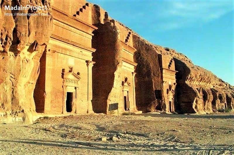
Hegra reached its apogee under the Nabataean Kingdom (circa 2nd Century BCE–106 CE), whose capital was at ancient Petra. By the first century BCE, the Nabataeans had incorporated Hegra as their principal southern outpost, renaming and developing it as a major urban and funerary center. The site’s monumental rock-cut tombs—over one hundred in number—exhibit elaborate façades combining indigenous Arabian elements with Hellenistic decorative motifs, including pilasters, stepped crowning features, and inscription panels in Nabataean Aramaic. These tomb inscriptions provide detailed genealogical, legal, and chronological data, illuminating the social stratification and legal culture of the Nabataean community.
Urban features at Hegra included residential zones, water wells, cisterns, and possibly a fortified enclosure demarcating the settlement core. Its prosperity derived from its position along the incense and spice routes that conveyed aromatics and luxury goods from South Arabia toward the Mediterranean world. Administrative inscriptions attest to royal authority exercised in the name of Nabataean kings, reflecting the integration of Hegra into a centralized yet regionally adaptive political system. The material culture of this period demonstrates both local continuity and cosmopolitan influences, underscoring Hegra’s role as a conduit between Arabia and the wider Near Eastern world.
Roman Annexation and Late Antique Transition
In 106 CE, the Nabataean Kingdom was annexed by the Roman Empire under Emperor Trajan, becoming part of the province of Arabia Petraea. Hegra continued to function as a regional center, though evidence suggests a gradual decline in monumental construction and long-distance trade prominence. Roman administrative practices were introduced, and the integration of the region into imperial infrastructure likely altered trade dynamics by redirecting commercial flows and emphasizing alternative routes.
Archaeological traces from the subsequent centuries indicate reduced urban vitality, with some continuity of occupation but diminished political significance. The transition reflects broader economic and geopolitical shifts in Late Antiquity, including changing trade networks and the reorientation of imperial priorities. By the fourth century CE, Hegra’s prominence had substantially waned, leaving behind its distinctive funerary landscape as the principal testament to its former status.
Early Islamic Period and Medieval Memory
Following the rise of Islam in the seventh century CE, the region encompassing Hegra was incorporated into the expanding Islamic polity. While the site itself did not reemerge as a major urban center, it lay along pilgrimage and trade routes connecting the Levant and Arabia. Islamic literary traditions from this period also associated the area with the Qur’anic narrative of the people of Thamud and the prophet Salih, contributing to its layered religious memory. Medieval geographers and travelers referenced the site’s carved rock façades, often interpreting them through Islamic historiographical frameworks that emphasized moral exempla and divine retribution.
Although no large-scale Islamic urban redevelopment occurred at Hegra, its continued recognition in textual sources ensured its preservation within regional consciousness. The monumental tombs remained visible markers in the desert landscape, shaping the site’s reputation in both local tradition and broader Islamic scholarship.
Modern Rediscovery and Heritage Designation
European exploration in the nineteenth century brought renewed scholarly attention to Hegra, with travelers documenting its inscriptions and architecture. Systematic archaeological investigation expanded in the twentieth and twenty-first centuries CE under the auspices of Saudi and international missions. The site, commonly known today as Madain Saleh, has been recognized for its outstanding preservation of Nabataean funerary architecture and epigraphy.
In 2008 CE, Madain Saleh was inscribed on the UNESCO World Heritage List, marking it as the first World Heritage Site in Saudi Arabia. Contemporary conservation initiatives emphasize both archaeological research and controlled cultural tourism, situating the site within broader national heritage strategies. The cumulative historical layers of Madain Saleh—spanning pre-Nabataean settlement, Nabataean florescence, Roman incorporation, and Islamic remembrance—render it a key locus for understanding the longue durée of northwestern Arabian history.
circa 100 CE

Jabl al-Ahmar
Jabl al-Ahmar (جبل الاحمر) also known as the Area C is an outcrop in the southeastern part of Mada’in Saleh that contains numerous tombs, dating to 16-61 CE. It is located in the southeastern portion of Madain Saleh and features three tombs with drawings dating to between CE 16 and CE 61. The tombs are burial chambers without special adornments. Consists of a single isolated outcrop containing 19 cut tombs, and no ornamentations were carved on the façades.
circa 100 CE

ad-Diwan
The triclinium style ad-Diwan (ديوان), also spelled as al-Diwan, is a square chamber containing three stone benches that served as a triclinium for sacred feasts. Today, the chamber is known as al-Diwan (court). Its large entrance suggests that the feasts extended into the open space before it. The Diwan itself was a place reserved for religious gatherings and consisted of a rectangular room carved in the rock measuring 12.8 x 9.9 metres and 8 metres in height.
circa 100 CE
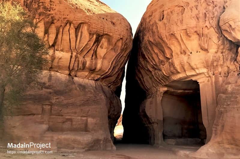
al-Siq
The narrow passageway known as the al-Siq (السيق), reminiscent of the Siq in Petra, runs towards the south from al-Diwan, measures about 40m wide between two rock faces lined with more small altars. The jagged cliff walls of the siq, the natural passageway leading to Jabal Ithlib, had decorated votive niches to Nabatean gods carved into the rock and petroglyphs of camels and traders.
circa 100 CE

Qasr al-Bint
The Qasr al Bint (قصر البنت), “Palace of the Daughter or Maiden,” is the largest tomb façade at Mada’in Saleh, with a height of 16 m. It lends its name to the group of adjacent tombs as well. The portal is raised above ground. Above the doorway an inscription plaque indicates that it dates to circa 31 CE. It consists of a wonderful row of facades that makes for dramatic viewing from across Madain Saleh. The east face has two particularly well-preserved tombs.
circa 100 CE

Qasr al-Farid
The Qasr al-Farid (قصر الفريد), an unfinished tomb that stands alone. The facade was never finished, so the heavily chiseled surface of the lower third documents how the tombs were fashioned from the top down. It is the most photogenic and most iconic symbol of Mada’in Saleh, a single tomb carved into a small dome that stands alone in the open. The façade was never finished, so the heavily chiseled surface of the lower third documents how the tombs were fashioned from the top down.
circa 100 CE

Qasr al-Sanea
The Qasr al-Sanea (قصر الصانع), was one of the first tombs to be carved in the al-Hijr area. It served as a prelude to the other Nabataean architectural style tombs. It is one of the best preserved tombs in Madain Saleh. It represents an introduction to the key elements of the style of the Nabatean’s tombs. It has a great facade, with five stepped crow-steps, and the inscriptions at the top of the door and the niches inside the structure into which the dead bodies were placed.
circa 100 CE

Unfinished Tomb
circa 100 CE

Ottoman Caravanserai
Between 1744 and 1757, a fort was built at al-Hijr (Madain Saleh) on the orders of the Ottoman governor of Damascus, As'ad Pasha al-Azm. A cistern supplied by a large well within the fort was also built, and the site served as a one-day stop for Hajj pilgrims where they could purchase goods such as dates, lemons and oranges. It was part of a series of fortifications built to protect the pilgrimage route to Mecca.
Signup for our monthly newsletter / online magazine.
No spam, we promise.
The Madain Project is an online archive of Abrahamic History and Archaeology.
Abrahamic History & Archaeology is the study of history and archaeology with respect to the three Abrahamic Faiths without considering the religious and theological aspects. The goal of Abrahamic History is to understand how and why the religious doctrines and behaviours have evlovled and changed over time. Searching for patterns in the evolution of significant cultural events such as the development of farming, the emergence of cities, or the collapse of major civilizations for clues of why and how these have influenced the three major Abrahamic religions.
Cloud Drive -
About -
Help -
Editorial Policy -
AI Policy -
Privacy Policy -
Contact
Madain Project: Encyclopedia of Abrahamic History & Archaeology.
Copyright MadainProject 2017 - 2026.
![]()
![]()
![]()
![]()
![]()
![]()