Girsu (Ĝirsu) was a city of ancient Sumer, situated approx 25 kilometers (16 miles) northwest of ancient Lagash, at the site of what is now Tell Telloh in Dhi Qar Governorate, in present day Iraq. As the religious center of the kingdom of Lagash, it contained significant temples to the god Ningirsu (E-ninnu) and his wife Bau and hosted multi-day festivals in their honor.
The site of Girsu was first extensively excavated by the French vice-consul at Basra, Ernest de Sarzec, who conducted eleven campaigns between 1877 and 1900 CE. His excavations uncovered a wealth of material, including numerous cuneiform tablets, sculptures, and inscriptions. Despite these significant findings, the site was also subjected to extensive looting, with an estimated 35,000 to 40,000 tablets entering the antiquities market during this period. Sarzec's work was followed by that of his successor, Gaston Cros, who continued excavations from 1903 to 1909 CE. Artifacts recovered from this period were divided between the Archaeological Museum of Istanbul and the Louvre Museum in Paris.
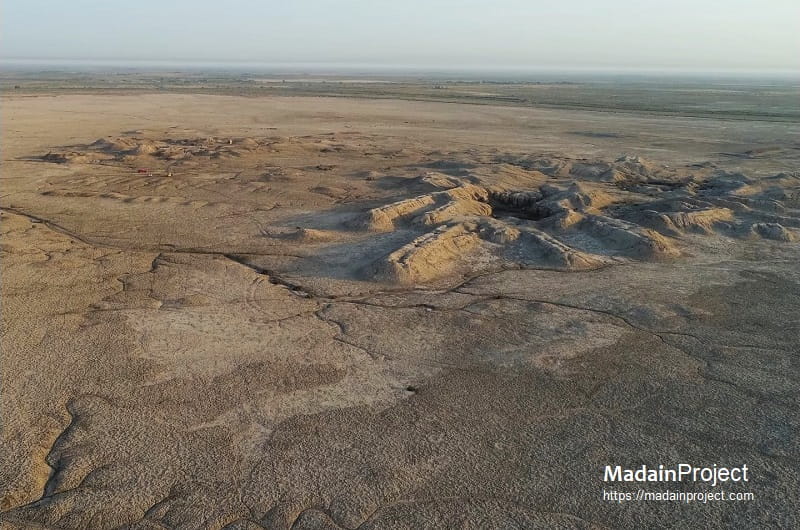
Girsu, known in modern times as Telloh, is an extensive archaeological site located in the southern Mesopotamian plain, near the banks of the ancient Iturungal canal. The site consists of several mounds, two of which are particularly prominent. The largest mounds, Tell A and Tell B, rise approximately 50 and 56 feet (15 and 17 meters) above the surrounding plain. These mounds, along with others at the site, are designated from Tell A to Tell Y, although many of these smaller mounds lack significant archaeological findings. Only a select few mounds, however, contain evidence of substantial urban, religious, or administrative activities during different periods of occupation.
The site of Girsu (modern Telloh, Iraq) is currently being studied, conserved, and preserved through the Girsu Project, an integrated program of archaeological research, training, and heritage management. Excavations are ongoing, focusing on systematically documenting the city’s mounds, temple precincts, administrative areas, and canal infrastructure, which were previously exposed by early unmethodical digs and looting. The project employs modern archaeological techniques, including detailed stratigraphic recording, 3D mapping, and digital documentation, to ensure that structures and artifacts are carefully studied within their original context. In parallel, the initiative provides on-site training for Iraqi archaeologists, equipping them with skills in excavation, conservation, and artifact management.
circa 5300-150 BCE

Ubaid Period
Archaeological evidence indicates that Girsu was first occupied during the late Ubaid period (Ubaid 4: circa 5300–4800 BCE). Ceramic assemblages and settlement traces demonstrate that the site formed part of the southern Mesopotamian village network that expanded along canal systems in the alluvium. The settlement was located on a branch of the Iturungal canal, the southern of two major east–west waterways connecting settlements across the Lagash plain and extending toward Niĝin and Gu’abba. Hydrological reconstruction of the canal network suggests that the Id-Ninaki-gen-a canal branched from the Iturungal and flowed via Zabalam to Girsu, Uru-ku (often identified with al-Hibba), and Nina (Surghul). During this period the settlement was likely a modest agricultural community integrated into the early irrigation economy characteristic of southern Mesopotamia.
Uruk Period
Occupation continued into the Uruk period (circa 4000–3100 BCE), although the scale of settlement at Girsu appears limited compared with major urban centers such as ancient Uruk. Archaeological layers from this phase contain beveled-rim bowls, the diagnostic mass-produced pottery associated with Uruk administrative economies. Their presence suggests that Girsu participated in the broader economic and institutional systems that characterized the Uruk expansion, including ration distribution and centralized storage. However, the available evidence indicates that Girsu functioned primarily as a secondary settlement within the regional irrigation landscape rather than as a primary urban center during this period.
Early Dynastic Urbanization
Substantial activity at Girsu began during the Early Dynastic period (circa 2900–2335 BCE) when the site emerged as a major cultic and administrative center within the Lagash state. The city became closely associated with the cult of the warrior god Ningirsu, whose principal sanctuary, the E-ninnu (“House of Fifty”), stood there. Administrative tablets from this period indicate that Girsu functioned as a central node in the temple-based economic system of Lagash. Rulers such as Ur-Nanshe (reigned circa 2494–2465 BCE), Eannatum (reigned circa 2455–2425 BCE), and Enmetena (reigned circa 2404–2375 BCE) undertook construction projects in the city, particularly in connection with the Ningirsu temple complex. The famous Stele of the Vultures commissioned by Eannatum, commemorating Lagash’s victory over Umma in the Gu’edena border conflict, reflects the political prominence of the Lagash state during this period and indirectly underscores the importance of Girsu as its principal religious center. Administrative archives from Girsu document temple estates, agricultural production, labor allocation, and intercity political relations within the Early Dynastic city-state system.
Akkadian Period
Following the conquests of Sargon of Akkad (reigned circa 2334–2279 BCE), the Lagash region, including Girsu, came under the authority of the Akkadian Empire. Direct evidence from Girsu suggests continued occupation but reduced local autonomy, as imperial administration superseded the independent city-state system. Later Akkadian rulers such as Naram-Sin (reigned circa 2254–2218 BCE) maintained political control over southern Mesopotamia, and inscriptions attest to imperial oversight across the region. Nevertheless, the temple institutions at Girsu continued to function as major economic actors, managing agricultural land and labor under imperial authority.
Neo-Sumerian / Second Dynasty of Lagash
After the collapse of Akkadian power, Lagash experienced a political and cultural revival under the so-called Second Dynasty of Lagash. During the reign of Gudea (reigned circa 2144–2124 BCE), Girsu became the effective capital of the Lagash polity and the focal point of large-scale religious and architectural patronage. Numerous inscriptions from Gudea’s famous diorite statues describe the rebuilding of the E-ninnu temple of Ningirsu at Girsu. These inscriptions provide detailed accounts of temple construction, procurement of materials from distant regions such as Magan (present day Oman) and the Amanus mountains, and the ritual dedication of the sanctuary. Administrative tablets from the city document temple-centered economic administration, including agricultural production, labor mobilization, and long-distance trade networks. During this period Girsu functioned simultaneously as a political capital, religious center, and administrative hub of the Lagash state.
Ur III Imperial Period
With the rise of the Third Dynasty of ancient Ur under Ur-Namma (reigned circa 2112–2095 BCE), the Lagash territory was incorporated into the Ur III imperial system. Girsu became an important provincial administrative center within the centralized bureaucratic structure of the empire. Thousands of cuneiform tablets from the site document the management of agricultural estates, livestock, labor forces, and taxation. Officials such as ensi-governors and royal administrators coordinated production and redistribution through temple and state institutions. The archive from Girsu is among the largest sources of administrative documentation for the Ur III state and illustrates the highly structured economic management characteristic of the period.
Old Babylonian Period
Following the collapse of the Ur III state, Girsu remained inhabited during the Isin-Larsa and Old Babylonian period (circa 19th–18th centuries BCE), although its political significance declined. In the mid-18th century BCE the city became involved in a regional rebellion or revolt led by Rim-Sîn II of Larsa (reigned circa 1742–1739 BCE). This uprising involved several southern Mesopotamian cities resisting the authority of the First Dynasty of Babylon under Samsu-iluna (reigned circa 1749–1712 BCE). Textual evidence indicates that Girsu was among the cities participating in the revolt. The rebellion was ultimately suppressed by Samsu-iluna, after which many southern urban centers experienced economic contraction and population decline.
Sealand Dynasty
Archaeological evidence from pottery assemblages indicates that Girsu remained occupied during the period associated with the First Sealand Dynasty (circa 1796–1524 BCE), which controlled parts of southern Mesopotamia after the weakening of Babylonian authority. Although textual evidence from Girsu itself is limited, ceramic material suggests continued, though diminished, settlement activity during this era.
Late Occupation and Hellenistic Period
Although Girsu never regained its earlier prominence after the Old Babylonian period, archaeological evidence indicates intermittent occupation into the first millennium BCE and beyond. The site remained inhabited at least until around 200 BCE. A notable discovery is a bilingual Greek–Aramaic inscription dated to the fourth century BCE, indicating activity at the site during the late Achaemenid or early Hellenistic period. This inscription demonstrates that the location retained some degree of local significance even after the decline of the ancient Sumerian urban system.
Overall, the history of Girsu reflects the broader political and economic transformations of southern Mesopotamia, from early irrigation settlements of the Ubaid period through the city-state system of the Early Dynastic era, imperial incorporation under Akkad and Ur III, and eventual decline in the post-Old Babylonian landscape.
circa 5300-150 BCE
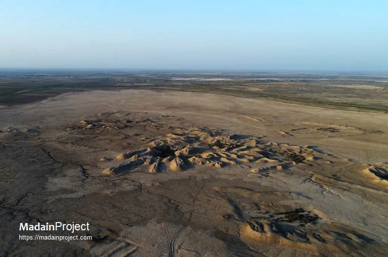
Tell A – The Mound of the Palace
Tell A represents the most prominent mound at the site and has long been identified as the “Mound of the Palace”. The uppermost level of the mound preserves the remains of a palace belonging to the obscure ruler Adad-Nadin-Akhe, dated to the Seleucid, Hellenistic or late Aramaic period. The attribution is based on bricks bearing inscriptions of this ruler. The palace complex incorporated reused sculptural material from earlier periods, including several inscribed diorite statues of the Lagash ruler Gudea (reigned circa 2144–2124 BCE), indicating the reuse of earlier Sumerian monuments in later constructions.
Excavations beneath the Hellenistic structure have revealed a substantial temple precinct belonging to the earlier Sumerian city. This precinct contained the E-ninnu (“House of Fifty”), the principal sanctuary of the warrior god Ningirsu, the tutelary deity of the Lagash state. The temple complex was extensively rebuilt during the reign of Gudea and served as one of the central religious institutions of the city. Recent excavations have also identified ritual installations and cultic deposits within this area, including large concentrations of ceremonial vessels and animal remains associated with temple activities.
Tell B – Early Dynastic Buildings and Tablets
Tell B has produced architectural remains and cuneiform tablets dating primarily to the Early Dynastic period (circa 2900–2335 BCE). Excavations have revealed portions of domestic and administrative buildings, indicating that this mound formed part of the inhabited urban quarter of the city during the third millennium BCE. Numerous administrative tablets recovered from this area document temple economy operations, including agricultural management, labor organization, and the distribution of commodities. These finds demonstrate that Tell B functioned as a sector closely tied to the institutional administration of Girsu during the period when the city served as a major cultic center of the Lagash polity.
Tell K – Maison des Fruits
Tell K contains the remains of a small temple structure known as the Maison des Fruits, attributed to Ur-Nanshe, ruler of Lagash in the mid-third millennium BCE (reigned circa 2494–2465 BCE). The building measures approximately 10.5 × 7.3 m and was constructed atop an earlier structure sealed beneath a thick layer of clay approximately 70 cm deep. This earlier phase was designated by the original excavators as the Construction Inférieure. Several foundation tablets and two inscribed door sockets were recovered from the structure, confirming its dedication under Ur-Nanshe and illustrating the long tradition of temple construction at the site. The mound likely formed part of a broader religious district associated with subsidiary cult buildings connected to the major temples of the city.
Tells L/M – Temple and City Wall Structures
The mounds designated L and M lie near the ancient city wall and have yielded evidence of temple-associated installations and architectural features. Excavations in this sector uncovered foundation cones and other dedicatory objects typical of Sumerian temple construction. The finds suggest that this area formed part of a peripheral religious and institutional zone adjacent to the defensive or boundary structures of the city. The presence of foundation cones inscribed with the names of rulers indicates periodic rebuilding or renovation of structures in this sector during the Early Dynastic and later periods.
Tell P – Porte du Diable
Tell P, referred to by early excavators as the Porte du Diable, appears to mark an important architectural feature within the urban landscape, possibly associated with an ancient gate or passage. Although the exact function of the structure remains uncertain, its designation suggests that it may have formed part of an entranceway or controlled access point within the settlement or along the canal system that traversed the city.
Tell V – Temple of Ningešzida and Tablet Hill
Tell V represents one of the most archaeologically productive sectors of the site. This mound contained the remains of a temple dedicated to the deity Ningešzida, a chthonic god associated with vegetation, fertility, and the underworld. The area surrounding the temple became known to excavators as “Tablet Hill” because of the exceptionally large number of cuneiform tablets recovered there. These tablets, numbering in the thousands, consist largely of administrative records documenting agricultural production, labor allocation, temple offerings, and other institutional activities of the Lagash state during the third millennium BCE. The concentration of administrative texts suggests that this sector of the city functioned as a major bureaucratic and archival center connected with the temple economy.
Urban Canal and Bridge Infrastructure
Recent excavations have also revealed elements of the city’s hydraulic infrastructure, including the remains of a brick-built bridge spanning an internal canal. This structure likely dates to the late third millennium BCE, possibly the Ur III period (circa 2112–2004 BCE), when Girsu served as a major administrative center within the Ur III state. The bridge crossed a canal channel connected to the wider irrigation network of the Lagash region and demonstrates the integration of water management systems into the urban layout of the city. The presence of such infrastructure illustrates the importance of canal transport and irrigation within the functioning of Girsu’s urban economy.
Together, the various mounds of the site preserve the remains of temples, administrative buildings, residential areas, and hydraulic installations that collectively illustrate the complex urban organization of Girsu during its peak in the third millennium BCE. The distribution of temple precincts, archival areas, and infrastructural features across different tells reflects the institutional character of the city as a major religious and administrative center of the Lagash state.
circa 5300-150 BCE
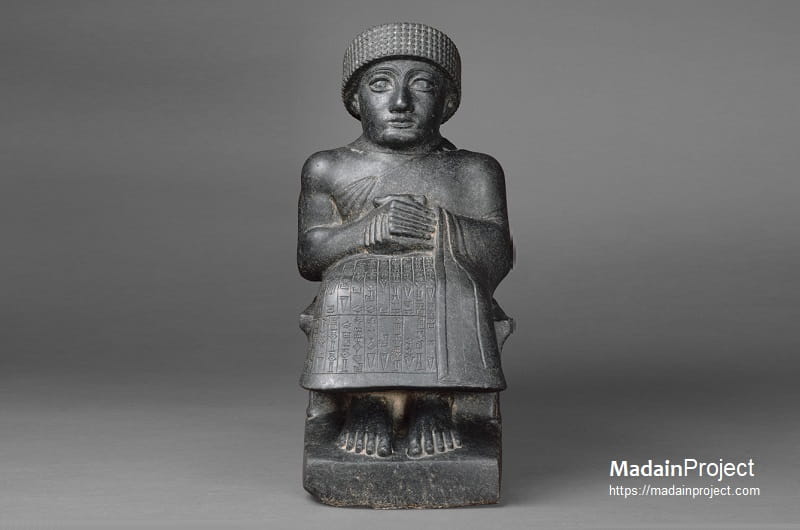
Statue of Gudea
The Seated Statue of Gudea dedicated to the god Ningishzida (often called "Statue I" or the "Petit Gudea") represents a more intimate and exclusively devotional aspect of Neo-Sumerian kingship compared to the larger architectural variants. Excavated at Girsu and now held in the Musée du Louvre, this diorite figure is noted for being one of the only examples recovered with its head intact, featuring the characteristic wide, alert eyes and the traditional brimmed wool cap of the ensi. Unlike the "Architect" statues, this figure lacks a tablet on its lap; instead, Gudea's hands are clasped in a tight, votive gesture of prayer over his waist, emphasizing his role as a humble servant to his personal protective deity. The surface is meticulously carved with cuneiform inscriptions that identify Gudea as the "builder of the temple" and record the statue's dedication to Ningishzida, the "Lord of the Tree of Life", ensuring the ruler's perpetual presence and piety within the sacred precinct.
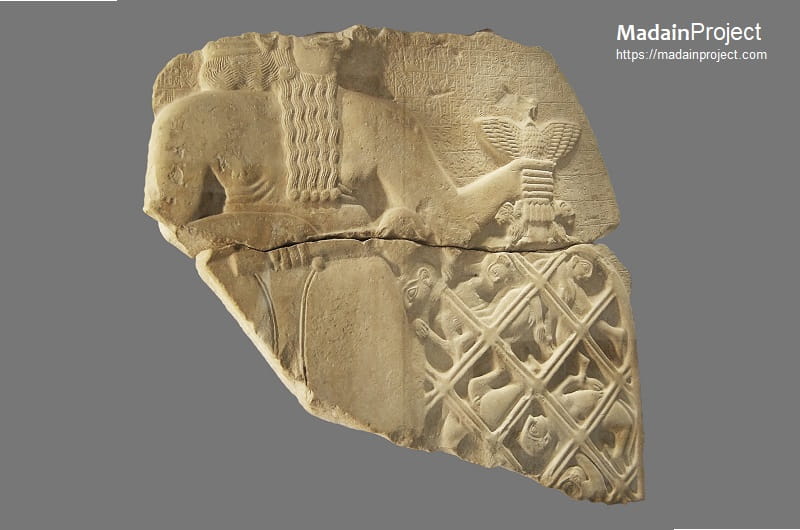
circa 5300-150 BCE
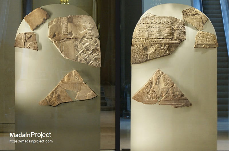
Stele of the Vultures
The Stele of the Vultures, an Early Dynastic III monument (circa 2450 BCE) recovered from Girsu and currently housed in the Musée du Louvre, serves as a foundational example of early Mesopotamian narrative art and military propaganda. Carved from a single limestone slab, the relief commemorates the victory of King Eannatum of Lagash over the rival city-state of Umma in a protracted border dispute over the fertile Gu-Edin. The monument is structured through a series of horizontal registers that bifurcate the event into terrestrial and divine spheres: the historical side depicts Eannatum leading a disciplined phalanx of soldiers—the earliest known representation of such a formation—trampling the bodies of enemies while vultures scavenge their remains. Conversely, the mythological side portrays the patron god Ningirsu holding a ceremonial mace and a large net containing captured foes, thereby legitimizing the conquest as an act of divine will rather than mere secular aggression.
circa 5300-150 BCE
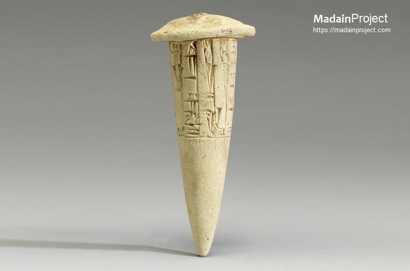
Foundation Clay Nail
The Foundation Clay Nail (or dedication cone) of the Neo-Sumerian period, particularly those commissioned by Gudea of Lagash (circa 2144–2124 BCE), serves as a critical lithic and epigraphic instrument for establishing divine ownership and the permanency of sacred architecture. Typically fashioned from baked clay in a conical or "nail" shape, these artifacts were inscribed with cuneiform text and embedded horizontally into the mudbrick walls or foundations of temples such as the Eninnu in Girsu. The inscriptions typically follow a rigid formulaic structure, identifying the ruler, his titles, and the specific deity—often Ningirsu or Nindara—to whom the edifice was dedicated. Beyond their structural role, these nails functioned as "letters to the gods" and historical markers for future restorers, ensuring that the ruler’s pious act of construction remained eternally recognized within the metaphysical fabric of the building.
Signup for our monthly newsletter / online magazine.
No spam, we promise.
The Madain Project is an online archive of Abrahamic History and Archaeology.
Abrahamic History & Archaeology is the study of history and archaeology with respect to the three Abrahamic Faiths without considering the religious and theological aspects. The goal of Abrahamic History is to understand how and why the religious doctrines and behaviours have evlovled and changed over time. Searching for patterns in the evolution of significant cultural events such as the development of farming, the emergence of cities, or the collapse of major civilizations for clues of why and how these have influenced the three major Abrahamic religions.
Cloud Drive -
About -
Help -
Editorial Policy -
AI Policy -
Privacy Policy -
Contact
Madain Project: Encyclopedia of Abrahamic History & Archaeology.
Copyright MadainProject 2017 - 2026.
![]()
![]()
![]()
![]()
![]()
![]()