The Lower Pergamon refers specifically to the archaeological sector situated at the base of the Pergamon-Acropolis hill in present-day Bergama, Türkiye. Unlike the acropolis or the upper city, which functioned primarily as the political and religious nucleus of ancient Pergamon, the lower city constituted a densely occupied urban and commercial zone. Archaeologically, it encompasses residential quarters, streets, marketplaces, sanctuaries, public buildings, and infrastructure associated with daily civic life during the Hellenistic and early Roman periods.
Excavations have identified the area as an organized urban fabric, with evidence of planned streets, water management systems, and multi-room houses, illustrating the complexity and sophistication of urban planning outside the citadel. The material culture recovered—including inscriptions, coins, ceramics, and architectural fragments—indicates sustained habitation, trade activities, and civic administration distinct from the monumental religious and political functions of the upper city (acropolis).
The lower Pergamon archaeological area is located at the northern and northwestern slopes of the Pergamon acropolis and extends into the surrounding plain. It served as the commercial, residential, and administrative heart of the city’s wider populace. Excavations have revealed a well-structured street network aligned with the topography, linking domestic spaces with civic buildings and marketplaces. Houses in this sector were generally multi-storied, constructed with local stone and brick, and often included courtyards, indicative of both functional and social organization. Notably, the lower city contained several sanctuaries and shrines, reflecting localized cultic activity that complemented the major temples atop the acropolis. Evidence of workshops, storage facilities, and commercial installations demonstrates that this area was integral to Pergamon’s economic life, facilitating the production and exchange of goods.
Hydraulic engineering features have also been documented, including aqueduct channels, wells, and drainage systems, illustrating the technical ingenuity employed to supply water and manage waste in a densely populated area. Archaeological layers show continuous occupation from the Hellenistic period, circa third century BCE, into the Roman Empire period, with modifications reflecting shifts in urban needs, architectural styles, and sociopolitical circumstances. Funerary remains and epigraphic records further illuminate the social stratification and everyday lives of residents, providing a detailed picture of a thriving urban community at the foot of the Pergamon acropolis.
The lower city, while less monumental than the acropolis, represents an essential component of Pergamon’s urban environment. It provides scholars with insights into the daily routines, economic mechanisms, and social structures that sustained one of the most influential cities of the Hellenistic world. Its preservation and study offer a counterbalance to the monumental focus of the upper city, highlighting the interdependence between civic life and elite patronage in ancient urban centers.
circa 350 BCE

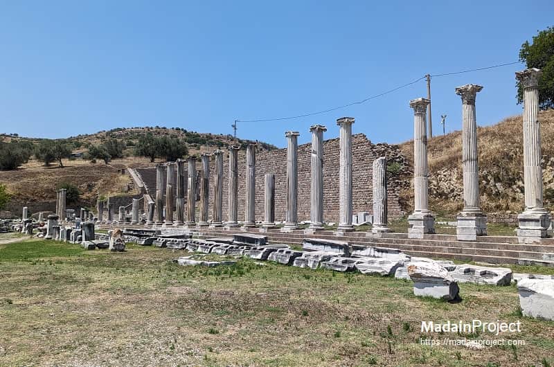
Sanctuary of Zeus-Asclepius
The Sanctuary of Zeus-Asclepius in Pergamon, constructed primarily during the Roman Imperial period around 150 CE, represents a convergence of religious, architectural, and medical thought in the ancient world. While the healing cult of Asclepius was established at the site in the 4th century BCE, the monumental complex visible in its final form was largely the product of extensive rebuilding under the reign of emperor Hadrian.
A distinctive feature of this Roman-era sanctuary was the round temple dedicated to Zeus-Asclepius, a smaller-scale replica of the Pantheon in Rome, commissioned by the wealthy consul Lucius Cuspius Pactumeius Rufinus. This architectural fusion symbolically elevated the patron god of healing by associating him with the king of the gods. Beyond its religious significance, the Pergamon Asclepieion was a hub of advanced medical practices for its time, integrating spiritual healing—such as dream interpretation (incubatio) conducted in underground passages—with physical treatments like hydrotherapy and herbal medicine.
The site thus functioned as a holistic medical and spiritual center, attracting notable figures like the physician Galen and the orator Aelius Aristides, and providing a powerful context for understanding Greco-Roman concepts of health and piety.
circa 10 BCE
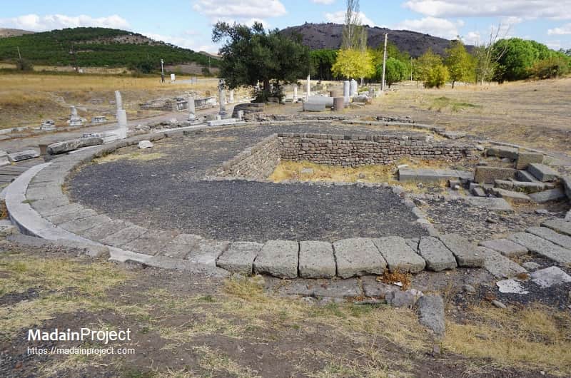
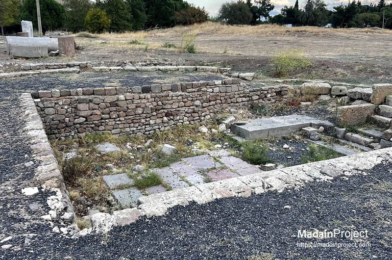
Heroon
Located within the lower archaeological area of ancient Pergamon approx. 80 meters north-east of the renowned healing sanctuary of the Asclepieion at Pergamon, a circular heroon was constructed during the reign of the Roman emperor Augustus. This monumental Roman tomb is situated along the final colonnaded stretch of the Via Tecta, a covered, 820-meter-long processional road connecting the urban center of Pergamon to the sanctuary complex.
The architectural remains indicate a large circular foundation, which enclosed an internal rectangular chamber (inspect). This structure was erected on the south side of the Via Tecta's colonnade, a pathway lined with halls and shops selling therapeutic or votive items. The placement of the heroon within this highly visible and monumentalized section of the sacred road points to its importance in the sanctuary's landscape.
As a Roman-period addition to the Hellenistic Asclepieion, this tomb illustrates the continued expansion and transformation of Pergamon's sacred spaces under imperial Roman patronage. The structure's function as a heroon, a sanctuary dedicated to a deified individual, further underscores the fusion of local and imperial religious practices in the Roman province of Asia.
circa 150 CE
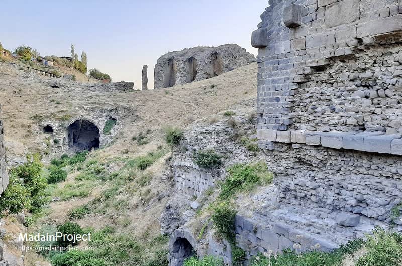
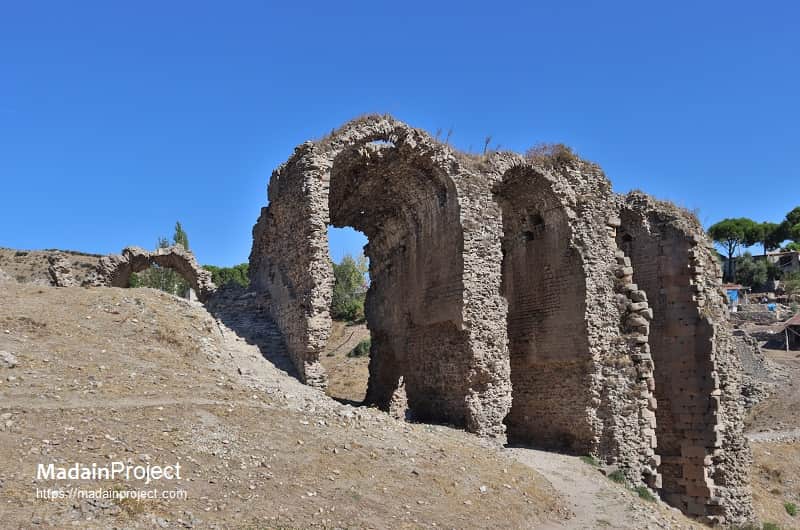
Amphitheater
The amphitheater of Roman Pergamon was an emblematic monument situated within the lower city, serving as a testament to the city's thorough Romanization during the imperial period. Built in the second century CE on the slopes of the Musalla Mezarlık hill, this structure is distinguished by its strategic location within a valley carved by the Selinus River. This allowed engineers to utilize the natural topography for construction while incorporating a vaulted water channel beneath the arena floor, which likely enabled simulated naval battles, or naumachiae, and other aquatic displays.
Unlike many Roman amphitheaters, archaeological research suggests a circular rather than an elliptical plan, a unique architectural adaptation to the specific terrain. The amphitheater hosted public spectacles characteristic of Roman imperial culture, such as gladiatorial combats (munera) and staged animal hunts (venationes), and recent archaeological findings confirm the presence of reserved seating for prominent citizens. The building fell into ruin by the early Byzantine period and its stones were systematically plundered for new constructions, yet its remains provide invaluable insight into the cultural and urban development of Roman Pergamon.
circa 98–117 CE

Via Tecta
The Via Tecta of Pergamon was the ancient covered road that connected the city proper with the Asclepieion, located approximately 3 kilometers southwest of the acropolis. Constructed during the Roman Imperial period, most likely under the reign of emperor Trajan (circa 98–117 CE) or possibly during the early Hadrianic period (circa 117–138 CE), the Via Tecta functioned as both a processional walkway and practical route for pilgrims, patients, and priests traveling between the urban core and the healing sanctuary. Archaeologically, it is identified as a colonnaded and partially vaulted roadway, paved with large stone slabs and flanked by retaining walls along the sloping terrain of the Kaikos valley.
The term “tecta” (meaning “roofed”) refers to its distinctive arched roof sections, designed to protect travelers from sun and rain while providing a monumental approach befitting the sanctuary’s sacred character. Inscriptions and architectural fragments found along the route suggest that portions of it were porticoed and lined with dedications by wealthy citizens and patrons of the Asclepieion. The Via Tecta not only symbolized the ritual transition from civic space to sacred precinct but also represented one of the finest examples of Roman urban infrastructure in Asia Minor, integrating engineering function with religious processional form.
circa 1500-1600 CE
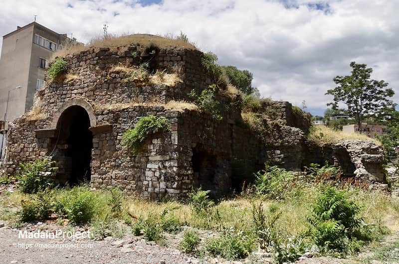
Tannery Baths
The so-called "tannery baths" (tabaklar hamami) is thought to be built in 15-16th century CE. It was given its name because of its location inside the tannery at the Selinos creek. The dome survives at the dressing section (camekan), while the rest of the domes were damaged. The dome is supported by Turkish triangles and stalactites (mukarnas). The bath was damaged during a flood in 1842 CE. The floor covering was entirely removed and part of it was buried under other structures. However, the furnace (kiilhan) of the bath still remains.
Signup for our monthly newsletter / online magazine.
No spam, we promise.
The Madain Project is an online archive of Abrahamic History and Archaeology.
Abrahamic History & Archaeology is the study of history and archaeology with respect to the three Abrahamic Faiths without considering the religious and theological aspects. The goal of Abrahamic History is to understand how and why the religious doctrines and behaviours have evlovled and changed over time. Searching for patterns in the evolution of significant cultural events such as the development of farming, the emergence of cities, or the collapse of major civilizations for clues of why and how these have influenced the three major Abrahamic religions.
Cloud Drive -
About -
Help -
Editorial Policy -
AI Policy -
Privacy Policy -
Contact
Madain Project: Encyclopedia of Abrahamic History & Archaeology.
Copyright MadainProject 2017 - 2026.
![]()
![]()
![]()
![]()
![]()
![]()