The infrastructure in Ancient Pompeii, modern day Italy, refers to the utilities and foundational systems and other facilities necessary for the city's operation, safety, and public health. The infrastructure in Pompeii encompassed water supply and drainage systems, roads and streets, and defensive structures. Each component played a vital role in the city's overall infrastructure network, reflecting advanced Roman architecture, engineering and urban planning.
The infrastructure of ancient Roman city of Pompeii was a sophisticated and integral part of its urban landscape and architecture. It included advanced water supply and drainage systems, well-designed roads and streets, and robust defensive structures.
These infrastructure elements not only supported the city's daily operations but also contributed to the health, safety, hygiene and overall quality of life of its residents. The ingenuity and effectiveness of Pompeii's infrastructure highlight the remarkable engineering capabilities of the Romans and their ability to create thriving urban environments.

circa 600-100 BCE
Fortifications
The fortifications of ancient Pompeii, built in various phases between sixth and first century BCE) were integral to the city's defense and played a crucial role in protecting its inhabitants from external threats. These fortifications consisted of robust city walls, strategically placed gates, and additional defensive structures like watchtowers. Together, they showcased the Roman expertise in military architecture and urban planning.
The city walls of Pompeii were substantial and strategically designed to provide maximum protection. Constructed primarily from a combination of local stone and rubble, these walls were built to withstand attacks and provide a formidable barrier against invaders. The walls were made using opus incertum, a technique involving irregularly shaped stones set in mortar, which provided strength and durability. In some areas, the walls were faced with opus reticulatum, a type of masonry with a net-like pattern of stones. The walls extended approximately 3.2 kilometers in length, enclosing an area of about 66 hectares. They varied in thickness and height, typically around 2.5 meters thick and up to 8 meters high, providing a solid defense perimeter.
Interspersed along the walls were watchtowers, used for surveillance and defense. These towers allowed guards to monitor the surrounding areas and provided strategic points for launching defensive measures during an attack.
Pompeii's city walls were punctuated by several gates that served as entry and exit points. Each gate was fortified and strategically located to control access to the city. The Porta Marina, one of the most significant gates, located near the harbor, provided access to the sea and facilitating trade and transportation.
circa 50 BCE
Gates
The gates of ancient Pompeii serve as a fascinating glimpse into the city's rich history and architectural ingenuity. These gates were crucial points of entry and exit, defining the city's layout and providing access to various parts of the town. Each gate, such as the Porta Marina, Porta Ercolano, and Porta Nocera, had its own unique characteristics and strategic importance. They were not only functional, facilitating trade and defense, but also symbolic, marking the transition between the bustling urban life within and the broader world outside. The remnants of these gates, with their impressive structures and inscriptions, offer valuable insights into the urban planning and daily life of Pompeii before the catastrophic eruption of Mount Vesuvius in 79 CE.
circa 50 BCE
Mensa Ponderaria
VII.7.31
In a niche in the western perimeter wall of the Sanctuary of Apollo there is a copy of the Mensa Ponderaria, the original of which is kept at the National Archaeological Museum of Naples. THe public weights and measures bench (Mensa delle Pubbliche Misure) is a counter used to check the capacity measures used for goods in trade. Both liquid and solid food, such as cereals, could be measured. These were placed in the appropriate containers and sealed with caps and then emptied after verification. This counter was already present in pre-Roman times, as indicated by three inscriptions in the Oscan language then deleted when colony was founded (80 BCE), and upgraded to the system of Roman weights and measures, as evidenced by the inscription that is still visible.
circa 40 BCE - 10 CE
Honorary Arch of Tiberius or Germanicus
This honorary arch is located at the North east corner entrance to the Forum, north of the Arch of Nero and south of the Arch of Caligula. This has also been referred [See notes] to as Arco di Nerone [Garucci], Arch of Nero Caesar (son of Germanicus) [Mommsen], Arco di Tiberio [Mau], Arco di Germanico e dei suo figli Druso e Nerone [Spano and Sogliano]. This arch was possibly surmounted by an equestrian statue of the Emperor Tiberius, with niches for statues of Drusus and Nero, and fountains on the other side.
circa 30 BCE
Large Water Tank
The water tank (Castellum Aquae) or the water distributor is situated at the north-eastern corner of the Regio VI, just inside the Vasuvian Gate (Porta Vesuvio). It was constructed at the highest point of ancient Pompeii (42 meters) and, through its connection with the Augustan aqueduct of Serino, near Avellino, the water supply was guaranteed to the entire city. The structure allows you to appreciate the high level of development achieved by hydraulic engineering at the time: the castellum had a large circular basin within, served by a pipeline found on the north side, and fitted with a gate system and breakwaters, which adjusted the water distribution accordingly. The water used the drop pressure to be conveyed from here towards three pipes at different heights. If necessary, these could be closed with wooden wedges. The structure was damaged by the earthquake in 62 CE and does not seem to have been in use at the time of the eruption in 79 CE, unlike the 40 fountains distributed around the city.
The water castellum (distribution tank) on the west flank of the gate is the terminus of a branch of the Serino aqueduct built by Augustus to supply the Roman naval base at Misenum around 35 BCE.
circa 20 BCE - 10 CE
Arch of Augustus
The Arch of Augustus (Arco di Augusto) is located in the north west corner of the Forum at the south west corner of the Temple of Jupiter. Also referred to as Arco di Druso, figlio di Tiberio [Spano and Sogliano]. It was one of four monuments for the imperial family, probably the pedestal for a colossal statue of Augustus.
circa 37 – 41 CE
Arch of Caligula
This arch is set astride Via di Mercurio, of which it marks the beginning, in front of the forum baths and the Temple of Fortuna Augusta, near the intersection where Via delle Terme, Via della Fortuna, Via del Foro and Via di Mercurio intersect. This is an honorary arch in brick with a single passage-way and its attribution to Caligula is based on an equestrian statue in bronze, found in fragments, which must have originally been set on the attic and which has been identified as Caligula. The arch was built on the same axis as the arch attributed to Tiberius or Germanicus, which constitutes a monumental entrance to the Civil Forum, and which was also topped by an equestrian statue.
circa 40 CE
Aqueduct
The city of Pompeii was supplied with water by the Aqua Augusta aqueduct system. The Aqua Augusta sourced spring water from the Apennine Mountains located to the east of Pompeii. Constructed to link various cities along the Bay of Naples to the springs at Serino, this aqueduct carried high-quality water over a distance of 96 kilometers, descending from an elevation of 370 meters above sea level to reach Pompeii (Olsson, 2015). Roman engineers designed the aqueduct with a continuous downward gradient, ensuring that gravity alone propelled the water throughout its entire journey.
circa 65 CE
Forum Lavatory
VII.7.28
Located in the north-west corner of the forum, this is one of the many public lavatories in Pompeii. The protruding stonework which can be seen around the edges of the latrine would have had the seats on them. Under the seats there was a flow of water taking away the waste and the drain can be seen at the back of the picture. Roman public toilets were communal and were not divided into cubicles as our toilets are today, only the wealthy had private toilets. The offset entrance allowed privacy for passers by.
circa 63 CE
Forum Granary
VII.7.29
The forum granary (Granai del Foro) stretches along the western side of the Forum with eight openings separated by brick pillars that was used as storage areas for the fruit and vegetable market (Forum Holitorium). Today they form the greatest archaeological inventory of the city and have more than 9000 artefacts from the excavations in Pompeii and its territory since the end of the 19th century. They preserve the terracotta crockery that was used in the last decades of life of the city for every day activities, such as pots and pans for cooking, jugs and bottles, and amphorae, large containers used to transport oil, wine and fish sauce throughout the Mediterranean. The exhibited items also include marble tables and baths for fountains that adorned the entrances of houses and some casts of victims of the eruption as well as that of a dog and a tree. The building was built after the earthquake of 62 CE and it might have not been completed at the time of the eruption.
circa
Roads and Streets in Ancient Pompeii
The roads and streets of ancient Pompeii were intricately planned and meticulously constructed, these thoroughfares were vital arteries that facilitated the movement of people, goods, and information throughout the city. Pompeii's streets were laid out in a well-organized grid pattern, reflecting the influence of Roman engineering principles that prioritized efficiency, functionality, and connectivity. The main streets, or "viae", were relatively wide (approx. 2.5 to 4.5 metres in width) and often lined with shops, houses, and public buildings, creating a bustling urban landscape that catered to the daily needs of its inhabitants.
Architecturally, Pompeii's roads were paved with large, polygonal stones that provided a durable and stable surface for both pedestrian and vehicular traffic. The roads were ingeniously designed with raised pedestrian sidewalks and stepping stones that allowed residents to cross the streets without getting their feet wet during heavy rains as the streets were often filthy due to the lack of a proper sewer network. This sophisticated drainage system, which channeled water into underground sewers, showcased the Romans' expertise in hydraulic engineering. Historically, the streets of Pompeii also served as social hubs where citizens gathered, conducted business, and participated in civic life. The wear patterns on the stone pavements, caused by the constant passage of carts and chariots, offer a tangible connection to the everyday experiences of the ancient Pompeians, highlighting the dynamic and interconnected nature of their urban environment.
In line with the patterns used for the street layout of Greek cities, Pompeii's main streets running from west to east were referred to as decumanus, while the streets generally running from north to south, connecting the various decumani, were known as cardo. Although, the streets bear names today, it was not always so. The names assigned by modern archaeologists reference to various notable houses, geographical landmarks, other cities and in some cases only due to the abundance of discoveries on a particular road, such as Via dell’Abbondanza (the street of abundance).
circa
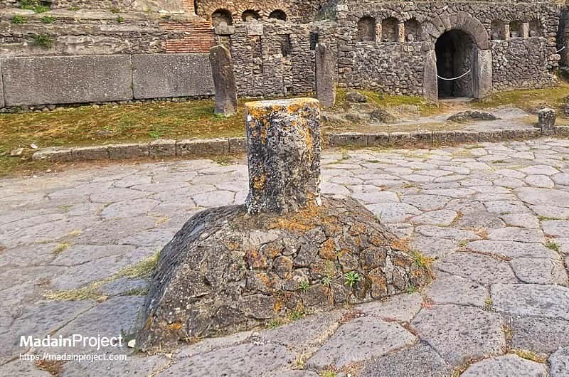
Public Water Fountains
The key elements in the water supply for the inhabitants of Pompeii were the 40 street fountains; almost all were equipped with a spout (plus a small sculpture) and a square or rectangular basin. Its overflow water went into the drain (where present). Some (nearly all) of the fountains were equipped with a hole just above the bottom, to be used during cleaning actions. Also there were no bigger fountains nor nymphea in Pompeii. The arch in the north-east corner of the forum may have been equipped with a reservoir feeding the fountain at the north side of the arch, but this container was situated too high to be fed with aqueduct water.
circa
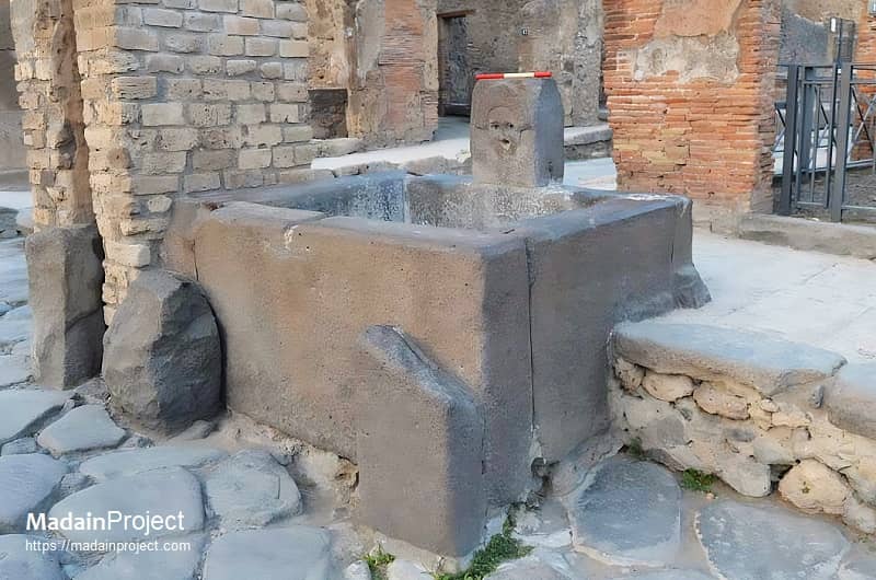
Fountain with comedy mask
This water fountain with a basin is situated outside the taberna of D. Juni Proculi (I.4.15) and adjacent to a water tower.
circa
Cippus of Suedius Clemens
The cippus of Titus Suedius Clemens is situated just outside the Porta Nocera, at the junction of Via delle Tombe and Via Nocera, in the southern necropolis of Pompeii. This location, near the intersection of prominent funerary and extramural roads, underscores the cippus’ function as both a boundary marker and a public legal statement. The cippus is oriented in relation to the southern exit of the city, and it belongs to a broader category of dedicatory or legal stone monuments placed along Pompeii’s main arteries outside the city gates. Its placement was likely strategic, intended to make its inscription highly visible to those entering or leaving through this gate. The Latin inscription on the south face of the cippus reads:
Ex auctoritate imperatoris Caesaris Vespasiani Augusti, loca publica, a privatis possessa, Titus Suedius Clemens tribunus, causis cognitis et mensuris factis, rei publicae Pompeianorum restituit.
By virtue of authority conferred upon him by the Emperor Vespasian Caesar Augustus, Titus Suedius Clemens, tribune, having investigated the facts and taken measurements, restored to the citizens of Pompeii public places illegally appropriated by private persons.
This inscription identifies the cippus as a juridical and administrative boundary marker resulting from a land restitution initiative during the early Flavian period. It references the authority of the emperor and the investigative actions of Suedius Clemens as a tribunus, or military tribune, acting as a legal envoy or commissioner tasked with land surveying and reclamation. The phrasing “rei publicae Pompeianorum” directly refers to the civic body of Pompeii, confirming the cippus’ role in restoring public land misappropriated by private individuals.
The cippus is a modestly sized, squared stone pillar, inscribed only on its south face, with the north side left uncarved. Its design conforms to other Flavian-period legal cippi found in the region, marked by formalized lettering and pragmatic physical form intended for outdoor endurance. No decorative features or symbolic embellishments are noted, aligning with its strictly legal and administrative function rather than commemorative or votive purpose.
This cippus is one of several similar markers set up after the eruption of 79 CE, indicating that a systematic land recovery effort occurred under imperial directive. Comparable cippi have been documented at other major city gates, including Porta Ercolano, Porta Marina, and Porta Vesuvio. Collectively, these stone monuments form a corpus of post-eruption interventions aimed at reasserting state control over public properties in the devastated city.
The phrase rei publicae Pompeianorum, preserved on one such cippus found in 1763, was pivotal in the modern identification of the buried city as Pompeii. Prior to this epigraphic confirmation, scholarly opinion was divided between Pompeii and nearby Stabiae as the true identity of the site beneath La Cività. The presence of Suedius Clemens’ cippus in situ therefore holds both legal-historical and historiographic importance.

Signup for our monthly newsletter / online magazine.
No spam, we promise.
The Madain Project is an online archive of Abrahamic History and Archaeology.
Abrahamic History & Archaeology is the study of history and archaeology with respect to the three Abrahamic Faiths without considering the religious and theological aspects. The goal of Abrahamic History is to understand how and why the religious doctrines and behaviours have evlovled and changed over time. Searching for patterns in the evolution of significant cultural events such as the development of farming, the emergence of cities, or the collapse of major civilizations for clues of why and how these have influenced the three major Abrahamic religions.
Cloud Drive -
About -
Help -
Editorial Policy -
AI Policy -
Privacy Policy -
Contact
Madain Project: Encyclopedia of Abrahamic History & Archaeology.
Copyright MadainProject 2017 - 2026.
![]()
![]()
![]()
![]()
![]()
![]()