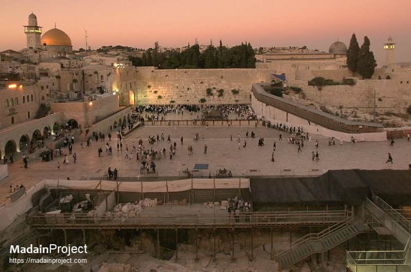
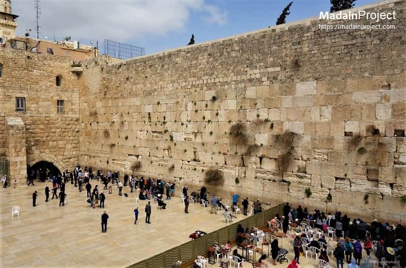
The Western wall, a remnant of Herod's grand temple, is the western retaining wall of the Temple Mount (Haram Sharif), in the Old City of Jerusalem. It forms part of the architectural support walls that enclosed the elevated platform on which the Jewish Temple stood. Following the 70 CE destruction of the Second Temple by Roman forces, the Western Wall remained intact and became the most prominent accessible remnant of the Temple complex. In Jewish tradition, the Western Wall holds exceptional religious significance and is regarded as the holiest site presently accessible for Jewish prayer. In Islamic tradition, the Western Wall—known as al-Burāq Wall—is associated with the Prophet Muhammad’s Night Journey and forms an integral part of the Haram al-Sharif (Noble Sanctuary), one of Islam’s holiest sites.
Being the holiest site for Jews, it attracts thousands of Jewish worshippers daily, who come to pray and lay out their problems and seek for heavenly guidance. They feel the presence of God's spirit, who according to their belief resides for thousands of years in the holy temple. The western wall is believed to be the remnant of the Herod's Temple.
The Western Wall, Wailing Wall (Hebrew: הַכּוֹתֶל הַמַּעֲרָבִי, HaKotel HaMa'aravi), often shortened to Kotel or Kosel, known in Islam as the Buraq Wall (Ḥā'iṭ al-Burāq حَائِط ٱلْبُرَاق) is an ancient limestone wall in the Old City of Jerusalem.
The wall was originally erected as part of the expansion of the Second Jewish Temple begun by Herod the Great, which resulted in the encasement of the natural, steep hill known to Jews and Christians as the Temple Mount, and Muslims as the Haram as-Sharif.
circa 100 BCE
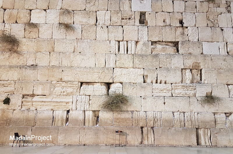
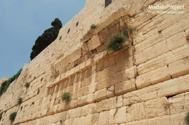
The Western Wall is a monumental ancient retaining wall of the western flank of the Temple Mount platform in Jerusalem, originally constructed as part of Herod the Great’s extensive enlargement and leveling of the Temple Mount in the late first century BCE. It comprises large courses of meleke limestone ashlars, with the lower Herodian layers distinguished by massive stones—some exceeding 13 meters in length and weighing tens to hundreds of tonnes—featuring finely dressed faces with narrow drafted margins and smooth joints laid without mortar, typical of Herodian masonry.
The wall functions structurally to retain the artificial embankment that supports the elevated Temple Mount platform; its visible section at the Western Wall Plaza measures approximately 57 m in length and rises to a height of around 19 m above the plaza level, while the full retaining structure extends roughly 488 m with additional courses buried below ground or obscured by later construction. Above the Herodian core, smaller stones and courses reflect subsequent construction and restoration phases from later periods. Archaeological excavations, including the Western Wall Tunnel to the north, reveal 45 stone courses in this section, of which 28 are above ground and 17 subterranean, illustrating both the original engineering and later alterations to the wall.
circa 100 BCE
Wailing Wall
The Wailing wall also known in Arabic as Al-Buraq Wall is a section of the Western Wall of the Temple Mount, and is holiest site where Jews are permitted to pray. It is a relatively small segment of a far longer ancient retaining wall, known also in its entirety as the "Western Wall". The term Wailing Wall refers to the practice of Jews weeping at the site over the destruction of the Temples.
The term Wailing Wall is a historical designation used primarily in European and Christian sources from the medieval period onward to refer to the Western Wall, particularly the section accessible to Jewish worshippers prior to the 20th century. The name derives from observations of Jewish prayer practices at the site, including lamentations over the destruction of the Temple.

Herodian Street
The Herodian street and shops along the western wall of the Temple Mount (Haram al-Sharif). Pile of stones from 70 CE destruction of Jerusalem can also be seen in the background. It was a monumental, paved thoroughfare that ran along the base of the Western Wall of the Temple Mount and formed part of Jerusalem’s primary north–south urban axis during the late Second Temple period.
Archaeological evidence indicates that the street extended from the northwestern sector of the city, followed the full length of the western retaining wall to the southwestern corner of the Temple Mount, and continued southward through the City of David to the Pool of Siloam. Constructed originally during the reign of Herod the Great (reigned 37–4 BCE), the street was bordered by drainage channels, curbstones, and commercial installations, including shops abutting the wall. Stratigraphic analysis and numismatic evidence suggest that the paving stones were replaced or refurbished during the reign of Herod Agrippa I (circa 40–44 CE). Remains along the street include collapsed ashlars from the Roman siege of Jerusalem in 70 CE, which fell or were thrown from the Temple Mount above and were left in situ, providing direct archaeological testimony to the events surrounding the city’s fall.
Robinson's Arch
Robinson's Arch is the name given to a monumental staircase carried by an unusually wide stone arch, which once stood at the southwestern corner of the Temple Mount. It is named after the 19th-century CE American scholar Edward Robinson, who first identified its architectural function in 1838 CE. It was built as part of the expansion of the Second Temple initiated by King Herod at the end of the 1st century BCE. The structure consisted of a massive, wide-span arch that supported a stepped bridge or staircase rising from the Lower City, crossing the Tyropoeon Valley street below, and providing direct access to the Royal Stoa, a large basilical complex situated along the southern edge of the Temple Mount esplanade. The surviving springing of the arch remains embedded in the Western Wall, while archaeological excavations have revealed the fallen voussoirs, stair elements, and street-level paving beneath. The collapse of the structure is generally attributed to the Roman destruction of Jerusalem in 70 CE.
Little Western Wall
The Little Western Wall, also known as HaKotel HaKatan (or just Kotel Katan) and the Small Kotel, (Hebrew: הכותל הקטן), is a Jewish religious site located in the Muslim Quarter of the Old City of Jerusalem near the Iron Gate to the Temple Mount. It forms a continuation of the western retaining wall of the Temple Mount constructed during the Second Temple period, particularly as part of the Herodian expansion in the late first century BCE. Unlike the main Western Wall Plaza, this segment is situated in a narrow alley and remains largely in its original urban context. The wall itself dates from the Second Temple period, (516 BCE – 70 CE). The wall is oriented almost directly opposite the location traditionally identified in Jewish sources as the Holy of Holies, which has contributed to its religious significance.

Wilson's Arch and Synagogue
Wilson's Arch is the modern designation for the remains of a large ancient stone arch abutting the northern section of the Western Wall of the Temple Mount. It is supported against the Northeast corner of Jerusalem's Western Wall, so that it appears on the left to visitors facing the Wall. The arch is dated to the late Second Temple period, with later modifications during the Roman era, and originally formed part of an elevated bridge or causeway system providing access to the Temple Mount from the western side and Upper area of the city. Archaeological evidence indicates that the arch spanned approximately 13 meters (42 feet) and supported a roadway extending about 23 meters (75 feet), leading to a gate aligned with the Temple Mount’s surface level. The preserved upper portion of the arch is visible today, while its foundations and associated structures have been revealed through excavations beneath the present ground level. The arch is named after the 19th-century explorer Edward Robinson, who identified its function in 1838 CE.
Today the interior of the surviving structure of Wilson’s Arch is a covered prayer area commonly referred to as the Wilson’s Arch Synagogue. This space occupies a vaulted section along the Western Wall and incorporates the arch as part of its architectural framework. The area has been adapted in modern times for year-round Jewish prayer, offering shelter and proximity to the wall itself. Women's section/balcony is visible to the top left behind the book cabinet. Archaeological remains within the synagogue complex include multiple construction phases, reflecting continuous use and modification from the Second Temple period through the Roman, Islamic, and Ottoman eras. Today, the site functions both as an active place of worship and as an archaeological zone that preserves key elements of Jerusalem’s ancient infrastructure.

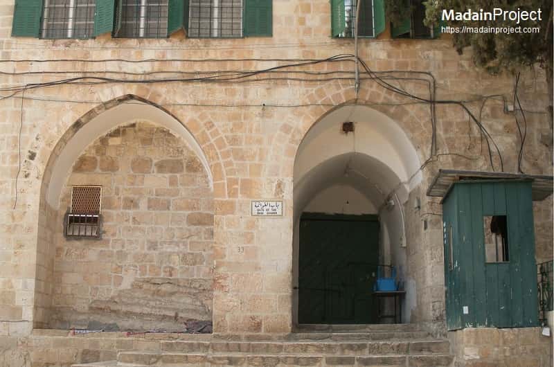
Gate of the Cotton Merchants
Cotton Merchants' Gate, (Bab al-Qattanin; Arabic: باب القطانين), is a monumental and one of the most beautiful gates that leads onto the Temple Mount (Haram al-Sharif) from the Cotton Merchants’ Market in the Old City of Jerusalem. It was constructed in 1336–1337 CE during the Mamluk period by Tankiz al-Nasiri, governor of Damascus, under the reign of Sultan al-Nasir Muhammad ibn Qalawun, as documented by a dedicatory inscription above the entrance. Architecturally, the gate is noted for its elaborate Mamluk stonework, including a muqarnas (stalactite) vault, ablaq masonry, and finely carved decorative elements, and is widely regarded as one of the most aesthetically refined entrances to the Haram al-Sharif.
Due to its location along the western boundary of the Temple Mount, the Gate of the Cotton Merchants is believed to have stood opposite the area traditionally identified with the Foundation Stone. In the 19th century CE, when Jewish access to the Temple Mount was restricted, the gate served as a focal point for Jewish prayer, as it represented the closest accessible point to the inner precincts of the former Temple without entering the temple precinct itself. Today, the gate remains in use as a principal pedestrian entrance to the Haram al-Sharif and as a significant example of Mamluk urban and religious architecture in Jerusalem.

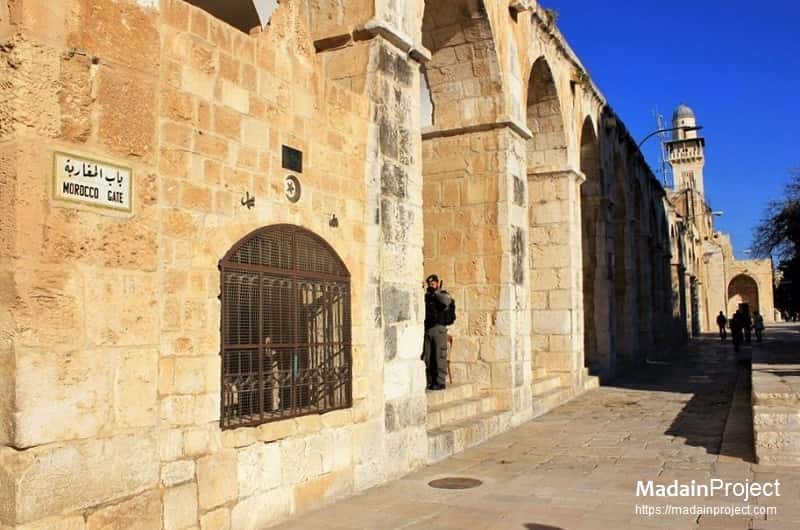
Moroccans' Gate
Bab al-Maghribah (Arabic: باب المغاربة), commonly known in English as the Moroccans’ Gate, is a gate set into the Western Wall of the Haram al-Sharif (Temple Mount) enclosure in Jerusalem. It constitutes the sole authorized access point for non-Muslims to enter the Haram al-Sharif (Temple Mount) area via a wooden ramp. To the right (north) is al-Buraq mosque and to the left (south) is Madrassah al-Fakhar. It was installed in the 12th century in the Western Wall above Barclay's Gate, at the level of the Temple Mount esplanade, and named after the residents of the adjacent neighborhood.
The name Bab al-Maghribah derives from the Maghrebi (North African) Muslim community that historically inhabited the adjacent Moroccan Quarter (Harat al-Magharbeh), located immediately outside the Western Wall. This neighborhood was endowed in the late 12th century CE, traditionally attributed to al-Malik al-Afdal, son of Saladin, as a waqf (religious endowment) for Muslims from the Maghreb who settled in Jerusalem following the Ayyubid reconquest of the city in 1187 CE. The gate functioned as the primary access route between this quarter and the Haram al-Sharif.
Scholarly consensus places the installation or formal adaptation of Bab al-Maghribah in the 12th century CE, during the Ayyubid period, although some elements of the gate’s structure may incorporate earlier masonry or reuse parts of previous gateways. The precise chronology of its construction remains debated, with the possibility of later modifications in the Mamluk or Ottoman periods. Nevertheless, its positioning above the so-called Barclay’s Gate indicates a deliberate reuse of the Western Wall’s monumental Herodian infrastructure to serve medieval access needs.

Ablution Gate
The view of the Ablution Gate (Arabic: Bab al-Matharah باب المطهرة) is a minor but architecturally and functionally significant gate of the Haram Sharif complex. It is situated a few meters to the south of Bab ul-Qattanin also located on the western flank.
Bab al-Muṭahhara dates to the Ayyubid period, reflecting the extensive architectural patronage undertaken in Jerusalem following the Muslim reconquest of the city in the late 12th century CE. Unlike most gates of the Haram al-Sharif, which provide direct access to one of the quarters of the Old City, the Ablution Gate is distinctive in that it does not open toward an urban neighborhood. Instead, it leads to a dedicated ablution facility (maṭhara), constructed specifically to serve worshippers performing ritual purification (wuḍūʾ) prior to prayer.
This ablution complex is traditionally attributed to the Ayyubid sultan al-Malik al-ʿĀdil Abū Bakr ibn Ayyūb (reign 1200–1218 CE), brother of Saladin. Its establishment reflects the Ayyubid emphasis on restoring and enhancing the religious infrastructure of the Haram al-Sharif, particularly facilities supporting Islamic ritual practice. The functional integration of the gate and the ablution area underscores the practical orientation of this entrance, which was intended primarily for religious use rather than ceremonial or civic passage.
The gate and its associated structures underwent a significant renovation in 666 Hijri (1267 CE), during the early Mamluk period, a time marked by continued architectural investment in the Haram al-Sharif. This restoration ensured the continued use of the gate and ablution facility while preserving their Ayyubid character within the evolving architectural fabric of the sanctuary.

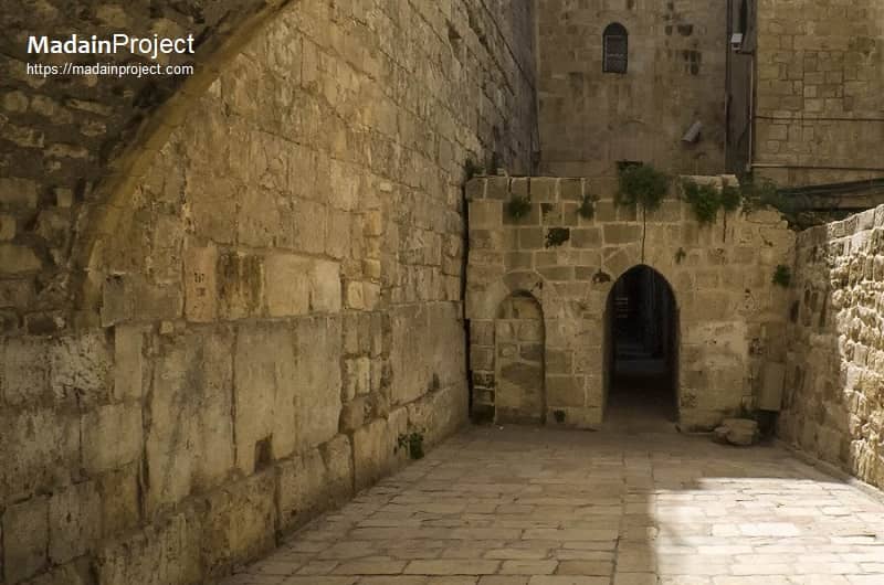
Barclay's Gate
The so-called Barclay’s Gate is a blocked monumental gateway set into the Western Wall of the Haram al-Sharif (Temple Mount) enclosure in Jerusalem. Today only part of its lintel (reverse L-shaped feature (identify)) in the western wall is visible. It is situated directly beneath the Moroccans’ Gate (Bab al-Maghribah) and is generally identified as one of the original Herodian-period gates that provided access to the expanded Temple Mount platform during the late Second Temple period (1st century BCE–1st century CE).
Its Arabic name is Bab an-Nabi, "Gate of the Prophet [Muhammad]" - not to be confused with the Triple Gate, which has the same Arabic name.
Archaeological and architectural analysis indicates that the original entrance of Barclay’s Gate reached a height of approximately 27 feet (about 8 meters). Remains of a structure attached to the Western Wall to the right (south) of the gate have been identified as part of a later ramp system, which led to the Moroccans’ Gate above. This superimposed arrangement illustrates the continued reuse and adaptation of the Western Wall across successive historical periods. While Barclay’s Gate itself was eventually sealed, its position beneath Bab al-Maghribah demonstrates how medieval and later builders integrated earlier Herodian infrastructure into new access routes serving the Haram al-Sharif.

Chain Gate
The Chain Gate, known in Arabic as Bab as-Silsileh (باب السلسلة) and in Hebrew as Shaʿar HaShalshelet (שער השלשלת), is one of the principal entrances to the Haram al-Sharif (al-Aqsa Mosque compound) on its western flank. The gate is widely regarded as one of the most important western entrances to the Haram al-Sharif due to its direct alignment with the central axis of the sanctuary. From Bab al-Silsilah, a straight processional route leads eastward toward the Dome of the Rock, underscoring the gate’s ceremonial and symbolic significance within the spatial organization of the compound.
The name Bab al-Silsilah (“Gate of the Chain”) is traditionally linked to Islamic lore associated with the Haram al-Sharif, particularly narratives concerning justice and divine judgment once symbolized by a miraculous chain believed to have hung within the sanctuary. Although the precise origin of the name remains debated, it has been firmly associated with this gate since the medieval period.
Scholarly tradition suggests that the Chain Gate may occupy, or be closely associated with, the location of the Coponius Gate, which existed during the Second Temple period (circa late 1st century BCE–1st century CE). While the physical remains of the Second Temple–period gate are not securely identifiable, the continuity of access at this point indicates the long-standing importance of this location within the western wall’s foot-traffic circulation system.
The present structure of Bab al-Silsilah dates primarily to the Ayyubid period, following the Muslim reconquest of Jerusalem in the late 12th century. The gate was constructed as part of the Ayyubid program of restoration and enhancement of the Haram al-Sharif and was renovated around circa 600 Hijri (1204 CE). This work is traditionally attributed to the Ayyubid rulers, who sought to reestablish Jerusalem as a major center of Islamic worship and learning.
Architecturally, the Chain Gate is dual portal and relatively tall and distinguished by the lack of its ornamented stonework, including a single arch above the entrance. It is fitted with a double wooden door, a feature common to major gates of the Haram al-Sharif. Within the larger doors is a smaller wicket opening, allowing controlled passage for a single individual when the main doors are closed, reflecting concerns for both security and regulated access.

Iron Gate
Bab ul-Hadid (iron gate) as seen from inside the Haram al-Sharif, it is located directly underneath the building known as Madarasa al-Uthmani. (Arabic: Bab al-Hadid, Hebrew: Shaar Barzel) is located on the western side, near the Little Western Wall. It is located in the western corridor of AlAqsa Mosque between the Inspector’s Gate and the Cotton Merchants’ Gate; it was last renovated in 1354-1357 CE (755-758 Hj.). It is also called Aragun’s Gate after its renovator and founder of the Araguniyah School Prince Aragun AlKamili.
Gate of Ghawanima
Gate of Bani Ghanim, as seen from within the Haram al-Sharif (Temple Mount). (Arabic: Bab al-Ghawanima), is located on the north-western corner. It was last renovated in 1308 CE (707 Hj.). It is a relatively small gate named after the Old City’s Bani Ghanim Quarter to which it leads. In the past, the Gate was called Al-Khalil (Hebron) Gate after Prophet Ibrahim Al-Khalil (PBUH). The Islamic Waqf Directorate has renovated this gate after an Israeli extremist burnt it in 1998.

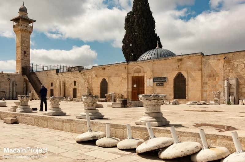
al-Fakhariyya Minaret
al-Fakhariyya minaret is located on the sout-west corner of Masjid il-Aqsa. It was built under the supervision of Sharif al-Din Abd al-Rahman on the orders of
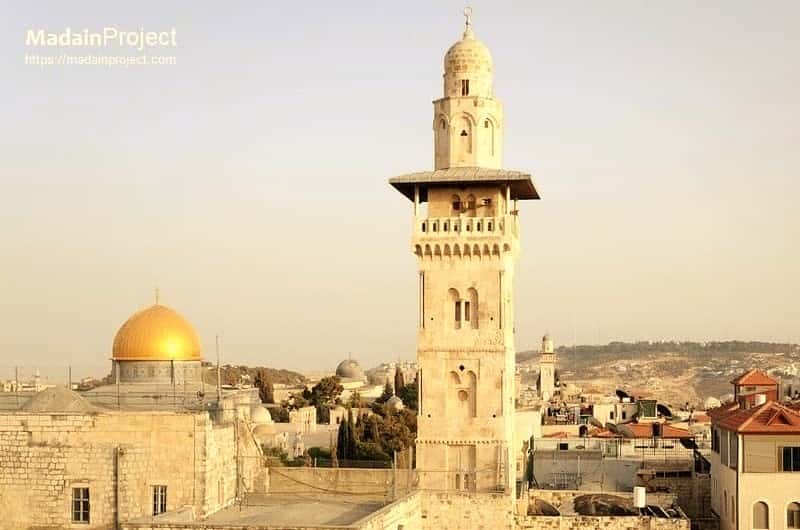
al-Ghawanima Minaret
al-Ghawanima minaret is the second of minarets and is located on the north-western corner of the noble sanctuary in 1297-98. It is the tallest minaret of Haram al-Sharif and was built by architecht named Qazi Sharaf al-Din al Khalili on the orders of Sultan Lajin. The minaret is almost completely made of stone except the wooden canopy over Muazzin's balcony. Because of its firm structure, the Ghawanima minaret has been nearly untouched by earthquakes.

Chain Gate Minaret
Bab al-Silsila minaret, (The Chain Gate Minaret) is located directly above the Gate of the Chain, thus named as such. Tanzik, the Mamluk Governor of Syria ordered the construction, probably replacing an earlier Umayyad built minaret. This reconstruction took place, as mentioned in the inscriptions, in the days of Sultan al-Nasir Muhammad, apparently by Amir Tankiz, governor of Syria, when he built the madrasa named al-Tankiziyya.
al-Buraq Mosque
This small structure, on the south-west corner of the al-Aqsa compound is believed to be the place where Muhammad tied the Buraq, the winged riding animal upon which he rode during the Night of Ascension, and an iron ring attached to the wall is shown to visitors as the exact place. It is in the passage that once led to Barclay's Gate, which is at the south end of the Western Wall and has been sealed for many centuries.
circa 1100 BCE
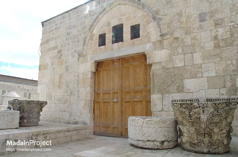
Islamic Museum
The facade of the Islamic Museum's building and the remains of Corinthian column capitals in the courtyard. On display are exhibits from ten periods of Islamic history encompassing several Muslim regions. The museum is located adjacent to al-Aqsa Mosque. The Islamic Museum was established in 1923 CE by the Supreme Islamic Council. It is considered to be the first museum founded in Palestine. The museum has two halls that form a right angle. The western hall was a mosque known as The Moroccans Mosque, while the southern hall is part of the Women’s Mosque.

Madrassah al-Ashraf
Madrasah al-Ashrafiyya is identified by its protruding volume into the Haram. Sultan al-Malik al-Ashraf Qaytbay (d. 1496 CE) founded al-Ashrafiyya on the same site. The builders and craftsmen, as well as the Coptic architect of al-Ashrafiyya, were all sent from Cairo to complete the building. The school consists of a two-storey building, and has a beautiful entrance decorated with white and red bricks. It also has a mosque that was once used by the followers of the Hanbali principle. There are two graves inside its mosque; one of them is thought to be Sheikh Al-Khalil’si tomb.
Madrassah al-Fakhariyya
It is an annex building served an assembly hall for the Fakhr al-Din Mohammad School, a madrasa built by al-Mansur Qalawun in 1282 CE, during the Mamluk era. Judge Fakhr Ad-Din Mohammad bin Fadl Allah built this school in 1329-1330 CE (730 Hj.). It was originally built as an Islamic religious school, but it was later turned into a Sufi lodge. Israeli forces have demolished parts of the school, leaving only three rooms and a small mosque out of its original building. The school’s mosque structure is simple; it is an oblong room which is based on three stone pillars and topped with three magnificent domes that were added to the building during the Ottoman era. The mosque also has a beautiful niche built with red bricks pointing towards the Qibla.
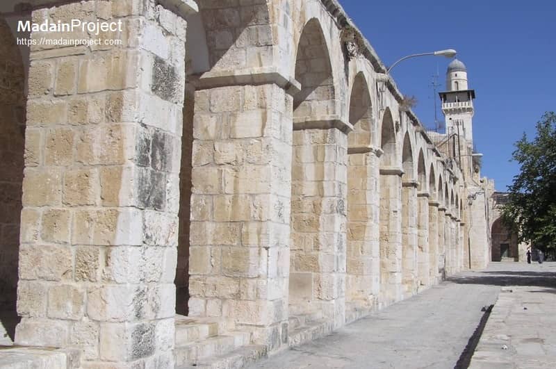
Western Colonnade
The western colonnade as seen from Bab al-Maghribah, standing right in front of al-Buraq mosque. To the right in the background the Minarah Bab us-Silsilah above Bab us-Silsilah.
The western colonnade of the Temple Mount (Haram al-Sharif) forms a continuous architectural and spatial feature running along the inner face of the western enclosure wall, providing covered circulation and framing the approach to several major gates, including Bab al-Silsilah, Bab al-Qattanin, and Bab al-Magharbeh. Its origins lie in the Second Temple period, when colonnaded porticoes were integral to the Herodian expansion of the Temple Mount, most notably the Royal Stoa along the southern edge; although the western colonnade as seen today does not preserve the Herodian superstructure intact, it occupies a zone of long-standing architectural continuity.
The present colonnade largely reflects Ayyubid and Mamluk construction and renovation, incorporating arcades, vaulted bays, and piers that unify circulation between gates, madrasas, and prayer spaces. Architecturally, it served both functional and symbolic purposes: providing shade and shelter for worshippers, structuring movement within the sanctuary, and visually articulating the western boundary of the esplanade. The western colonnade also functioned as a transitional space between the urban fabric of the Old City and the open sacred precinct, reinforcing the ceremonial importance of the western gates while integrating educational and religious institutions into the architectural framework of the Haram al-Sharif.

Maghrabi Bridge
The Mughrabi Bridge, also known as the Mughrabi Ramp, is an elevated wooden access structure that connects the Western Wall Plaza to the Mughrabi Gate (Bab al-Magharibah) on the western side of the Temple Mount (Haram al-Sharif) in Jerusalem. Functionally, it serves as the sole entry route designated by the Islamic Waqf for non-Muslim visitors to access the Temple Mount complex. The bridge occupies the approximate line of earlier historic access routes that linked the former Moroccan (Maghrabi) Quarter to the elevated Temple Mount esplanade. The current wooden structure is a modern installation, replacing earlier earthen and masonry ramps that deteriorated over time, particularly following the collapse of part of the historic ramp in the early 21st century. While utilitarian in appearance, the Maghrabi Bridge is of considerable religious, political, and archaeological sensitivity, as it lies adjacent to the Western Wall and leads directly into the Haram al-Sharif through one of its most historically layered gates.

Notable Burials
Immediately adjacent to Bab al-Qattānīn (the Cotton Merchants’ Gate) on the western side of the Haram al-Sharif lies a small but symbolically significant burial area associated with a number of prominent Palestinian, Arab, and Islamic political figures from the late Ottoman and modern periods. This concentration of graves reflects the longstanding tradition of interring notable individuals in proximity to the sacred precinct, particularly along the western enclosure, which has historically served as both a religious and commemorative landscape.
Among the figures traditionally identified as being buried in this area is ʿAbd al-Qādir al-Husseini (1907–1948), a leading Palestinian nationalist commander during the 1947–1948 conflict and a member of the prominent al-Husseini family of Jerusalem. His burial near the Haram al-Sharif underscores his status as a national and religious symbol within Palestinian collective memory.
Also associated with the vicinity is Musa Kazim Pasha al-Husseini (1853–1934), former Ottoman governor of Jerusalem and later president of the Arab Executive Committee. A central figure in Palestinian political life during the British Mandate, his interment near one of the principal gates of the sanctuary reflects both his civic stature and his family’s deep historical ties to Jerusalem.
The burial area is further linked to Faisal al-Husseini (1940–2001), a prominent Palestinian political leader and diplomat in the late 20th century. As a descendant of the al-Husseini family and a key figure in Palestinian national institutions, his association with this sacred zone reinforces the continuity of elite Jerusalemite families across Ottoman, Mandate, and contemporary periods.
In addition to Palestinian leaders, the area is traditionally said to include the graves of broader Arab and Islamic figures, including Emir Muhammad ʿAli and King Hussein of the Hejaz, although scholarly sources vary regarding the precise identification and attribution of individual tombs. Such associations reflect the broader role of Jerusalem as a focal point for Islamic memory and the commemoration of political and religious authority beyond the city itself.
Signup for our monthly newsletter / online magazine.
No spam, we promise.
The Madain Project is an online archive of Abrahamic History and Archaeology.
Abrahamic History & Archaeology is the study of history and archaeology with respect to the three Abrahamic Faiths without considering the religious and theological aspects. The goal of Abrahamic History is to understand how and why the religious doctrines and behaviours have evlovled and changed over time. Searching for patterns in the evolution of significant cultural events such as the development of farming, the emergence of cities, or the collapse of major civilizations for clues of why and how these have influenced the three major Abrahamic religions.
Cloud Drive -
About -
Help -
Editorial Policy -
AI Policy -
Privacy Policy -
Contact
Madain Project: Encyclopedia of Abrahamic History & Archaeology.
Copyright MadainProject 2017 - 2026.
![]()
![]()
![]()
![]()
![]()
![]()