Ancient Ubar (وبار) also spelled Wubar, modern day Shisr (الشصر), is an archaeological site in Dhofar province of modern day Sultanate of Oman, many names have been given to the lost city since its discovery in 1990 CE, Ubar, Wabar, Iram (ارم), and Atlantis of Sands being a few of many. Artifacts indicate the city came into existence sometime during the Bronze Age (circa 2800 BCE). Legend holds that it was destroyed by Allah because of the debauchery of its residents, but new evidence indicates it was destroyed, perhaps around CE 100 to 200, when a large limestone cavern beneath it collapsed. Located on a slight rise in the barren section what is now southern Oman known as the "Empty Quarter (الربع الخالي)". The fortress' large well was the only source of water for several days' journey.
Built nearly 5,000 years ago, Ubar was a processing and shipping center for frankincense, an aromatic resin grown in the nearby Qara Mountains. Used in cremations and religious ceremonies, as well as in perfumes and medicines, frankincense was as valuable as gold. Nicholas Clapp, the archaeologist who discovered and identified the site, speculates that the destruction of the city happened between 300 to 500 CE as the result of an earthquake which precipitated the collapse of the limestone table; but it was the decline of the incense trade, which led to the decline of the caravan routes through Shisr, that sealed Ubar's fate.
circa 400 CE

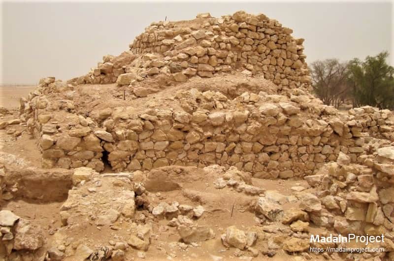
Remains of the fortress or an administrative structure, a large portion was destroyed when it collapsed into a sink-hole. It might have functioned as a guard post to administer the access to the water. This structure built by a local sheikh, dates back to about 1600 CE, and was built over the ruins of ancient Ubar and limestone blocks from Ubar were used in its construction. The ancient fortress was ringed by eight walls, each about two feet thick, 10 to 12 feet high and about 60 feet long.
circa 400 CE

A key to finding this old fortress was visible and reflected infrared images from the Landsat satellite and radar images taken from the space shuttle. These images revealed a regional network of tracks, some used by camels more than two thousand years ago and by 4-wheel-drive vehicles today, that pinpointed the city's location.
circa 400 CE

Artistic rendering of ancient city of Ubar of Qom-i 'Aad, to whome prophet Hud was sent. Located on an ancient Frankincense trade route in southern Arabia, the ancient lost city has been identified with City of Iram based on its archaeological features and description given in Quran, but there is no direct evidence found so far. The researchers have already found evidence that the climate was much different at the time when the city was populated.
circa 400 CE

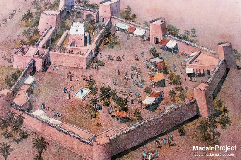
Sketch of Iram of Pillars; structure above the sink hole, could have been an administrative, religious or stronghold building guarding the water hole. There were eight pillars or guard towers around the complex, with three being the closest to the large administrative building. The walled complex may have had two gates in the opposing walls.
circa 400 CE
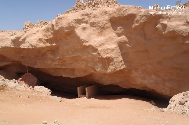
Remains of the Watering Hole
Modern entrance to the water hole, at the time of 'Aad the possible water level was up to the top of cliff. In building his "imitation of paradise," the legendary King Shaddad ibn 'Ad unknowingly constructed it over a large limestone cavern. Ultimately, the weight of the city caused the cavern to collapse in a massive sinkhole, destroying much of the city and causing the rest to be abandoned. The presence of the sinkhole confirms that the city met a cataclysmic end.
circa 400 CE

Defensive Towers
Foundation of one of the eight pillars, which were connect by a 30 feet high wall. Excavations at Ubar and surrounding area have helped identify and provide the first accurate information about the trade in frankincense, one of the first agricultural commodities to become an item of commerce. At each corner of the 12 feet high wall stood a tower, roughly 10 feet in diameter and 30 feet tall. The towers were the primary distinguishing feature of Ubar and are the strongest proof that this is in fact Ubar, which is described in the Koran as "the city many-towers".
circa 400 CE

Fortress-structure
Most Arabs in the past have lived not in traditional dwellings but in tents whose sides can be opened to allow cooling breezes. So the bulk of the "city" would have left few permanent traces, except for fire pits, which the team found in abundance. But at the center of the tent city was a permanent fortress that served as the home of the king, as a processing and storage facility for the frankincense and as a record-keeping center. In times of trouble, the fortress served as a safe haven whose walls and towers were never breached.
circa 400 CE

An arial view of Iram of Pillars, from "Civilization Lost", History Channel documentary. It was the center of the frankincense trade, the valuable substance used in cremations, in medicine and as a perfume -- was made from the sap of scraggly bushes from the Qara Mountains. It was processed in Ubar before being shipped northward across the desert on trade routes that led to ancient Sumer, as well as Damascus and Jerusalem.


Signup for our monthly newsletter / online magazine.
No spam, we promise.
The Madain Project is an online archive of Abrahamic History and Archaeology.
Abrahamic History & Archaeology is the study of history and archaeology with respect to the three Abrahamic Faiths without considering the religious and theological aspects. The goal of Abrahamic History is to understand how and why the religious doctrines and behaviours have evlovled and changed over time. Searching for patterns in the evolution of significant cultural events such as the development of farming, the emergence of cities, or the collapse of major civilizations for clues of why and how these have influenced the three major Abrahamic religions.
Cloud Drive -
About -
Help -
Editorial Policy -
AI Policy -
Privacy Policy -
Contact
Madain Project: Encyclopedia of Abrahamic History & Archaeology.
Copyright MadainProject 2017 - 2026.
![]()
![]()
![]()
![]()
![]()
![]()