Ancient Timgad (Arabic: تيمقاد; known as Marciana Traiana Thamugadi) was a Roman city in the Aurès Mountains of Algeria. It was founded by the Roman Emperor Trajan around CE 100. The full name of the city was Colonia Marciana Ulpia Traiana Thamugadi. Emperor Trajan named the city in commemoration of his mother Marcia, eldest sister Ulpia Marciana, and father Marcus Ulpius Traianus.
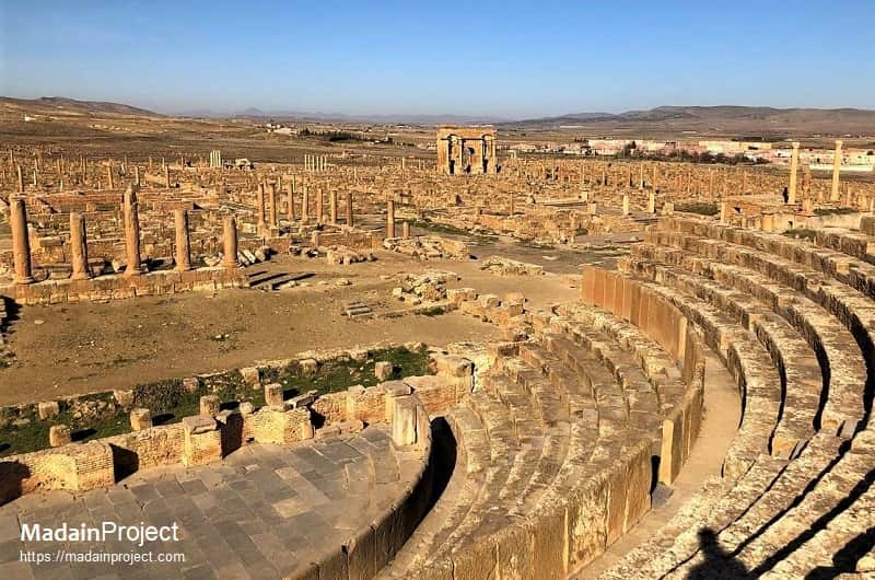
Located in modern-day Algeria, about 35 km east of the city of Batna, the ruins are noteworthy for representing one of the best extant examples of the grid plan as used in Roman town planning. Timgad was inscribed as a World Heritage Site by UNESCO in 1982. Located at the intersection of six roads, the city was walled but not fortified. Originally designed for a population of around 15,000, the city quickly outgrew its original specifications and spilled beyond the orthogonal grid in a more loosely organized fashion.
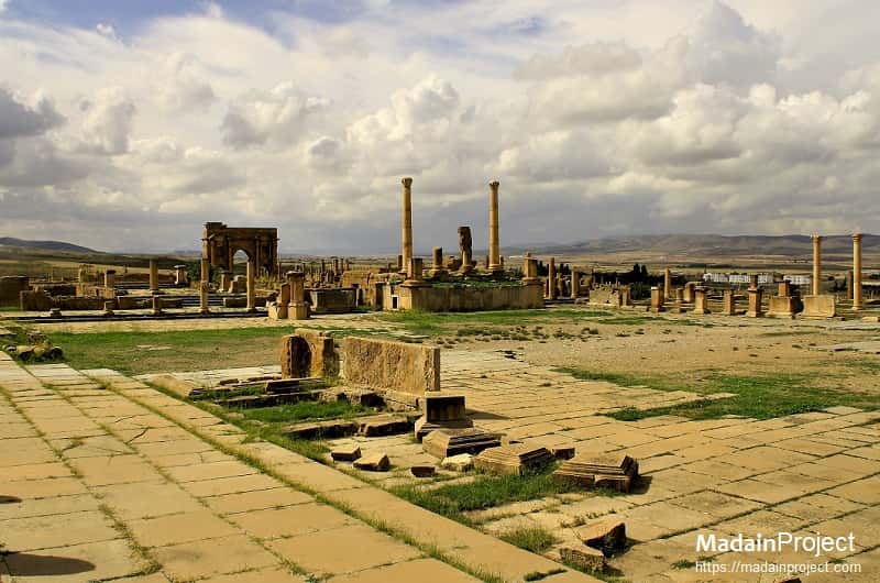
The original Roman grid plan is magnificently visible in the orthogonal design, highlighted by the decumanus maximus (east–west-oriented street) and the cardo (north–south-oriented street) lined by a partially restored Corinthian colonnade.
Established by Emperor Trajan in 100 CE as a colony intended for veteran soldiers, the Colonia Marciana Traiana Thamugadi was constructed by soldiers stationed at Lambaesis. Although the city's layout primarily had a military character, there is clear evidence that Thamugadi was designed to function as a town rather than solely as a military base. Its square shape consisted of a grid pattern with 111 blocks, each measuring 20 square meters. The majority of these blocks were divided into properties for individual settlers, while a significant number were allocated for public buildings.
After a period of Byzantine influence, Thamugadi was attacked and looted by Berber tribes in the seventh century CE, leading to its abandonment. Ironically, the encroachment of the Sahara Desert on the ruins became the primary reason for the remarkable preservation of the town. Due to the absence of subsequent settlements on the site after the seventh century CE, Thamugadi remained partially buried under sand, with a depth of approximately one meter, until its excavation in 1881 CE.

circa 50 CE

Early Period and Foundation (Numidian to Roman Era)
The area around Timgad, located in modern-day Algeria, was originally inhabited by the Numidians, an ancient Berber people. Archaeological evidence suggests that Timgad itself was founded in the early 1st century CE during the reign of the Roman Emperor Trajan. It was established as a Roman colonial city, likely to help consolidate Roman control over the region after the conquest of the Numidian kingdom. The city’s foundation, according to some inscriptions, was part of a broader Roman strategy to spread Roman culture and urban planning across North Africa. The site was strategically located along the Roman road network, making it an important hub in the Roman province of Africa Proconsularis.
Roman Period (1st Century CE - 5th Century CE)
Timgad flourished during the Roman period, reaching its height in the 2nd and 3rd centuries CE. The city was laid out according to the typical Roman grid pattern, with streets intersecting at right angles and public buildings like a forum, basilica, and temples, reflecting the wealth and organization of Roman urban life. Timgad became a prosperous city known for its impressive architecture, including a theater, library, and triumphal arches, such as the famous Arch of Trajan. The city was also an important military and administrative center, with a significant Roman garrison stationed there. Timgad remained a thriving city under Roman rule, and its strategic location made it a center for trade and communication between North Africa and the rest of the Roman Empire.
Christian Period (4th Century CE - 7th Century CE)
By the 4th century CE, Christianity began to take root in Timgad, with several churches being constructed in the city. The city's prosperity started to decline as the Roman Empire weakened, and it was affected by the political and economic instability of the late Roman period. During this time, many of Timgad's pagan temples were repurposed for Christian worship. The city saw a shift in its religious and social fabric, as more inhabitants embraced Christianity, evidenced by the numerous Christian inscriptions and basilicas that have been uncovered. Timgad continued to be an important Christian center in North Africa even as the Western Roman Empire began to crumble under the pressures of external invasions and internal decay.
Vandal and Byzantine Period (5th Century CE - 7th Century CE)
In the 5th century CE, Timgad fell under the control of the Vandal Kingdom following their invasion of North Africa. During this period, the city experienced further decline, and much of its infrastructure deteriorated. The Vandals ruled until the Byzantine Empire took control of the region in the 6th century CE. The Byzantines attempted to restore some order and rebuild the city, but Timgad never regained its former glory. By the 7th century CE, the city was largely abandoned, and many of its buildings fell into disrepair or were repurposed by local populations for other uses.
Medieval Period (7th Century CE - 15th Century CE)
After the Arab conquest of North Africa in the 7th century, Timgad fell into decline and was eventually abandoned. The city was partially destroyed, and its remnants became a source of building materials for later settlements. Over the medieval period, Timgad remained largely forgotten, with much of its former grandeur obscured by time and neglect. The site became a ruin, with local inhabitants occasionally using the area for grazing or as a source of stone. However, the city's ruins continued to serve as a testament to its once-grand past.
Modern Period (15th Century CE - Present)
The ruins of Timgad were rediscovered in the late 19th century, and since then, the site has been a major archaeological focus. Excavations have revealed the city's well-preserved Roman grid layout, its public buildings, and numerous inscriptions, providing a wealth of information about Roman and early Christian life in North Africa. In 1982, Timgad was designated a UNESCO World Heritage Site, recognized for its cultural and historical significance. Today, it is a popular tourist destination and an important site for the study of Roman and early Christian archaeology in North Africa.
circa 50 CE
Roman Forum
The forum was placed more or less centrally, where the main north-south street met the main east-west street. The square (50 x 43 meters) was surrounded by shops, a public lavatory, the judicial basilica, a temple dedicated to Trajan and his military victories and, in the north-east corner, the so-called Maison des Jardinières.
Constructed during the first century CE, the Roman Forum of Timgad followed the typical layout and design principles of Roman forums. It was a rectangular plaza surrounded by colonnades and lined with various public buildings. The forum served as a gathering place for the community, where residents would engage in social activities, conduct business transactions, and participate in political discussions.
The colonnades surrounding the forum provided covered walkways, offering shelter from the elements and creating a sense of grandeur. These colonnades often featured rows of columns with decorative capitals, showcasing the architectural finesse of the Roman Empire. The public buildings located around the forum included basilicas, temples, and administrative structures, serving as centers of governance and religious worship.
circa 150 CE

Capitolium
The Capitolium of Timgad refers to the central temple complex located in the ancient Roman city of Timgad, situated in present-day Algeria. It served as a focal point of religious and civic activities, reflecting the importance of the Roman state religion in Timgad. The Capitoline Temple was dedicated to the Capitoline Triad, consisting of the three major Roman deities: Jupiter, Juno, and Minerva. The temple complex is of approximately the same dimensions as the Pantheon in Rome. Nearby the capitol is a square church, with a circular apse dating from the seventh century CE. One of the sanctuaries featured iconography of (Dea) Africa.
Constructed during the second century CE, the Capitolium was an impressive architectural marvel, reflecting the grandeur and influence of Roman culture. It featured a traditional temple design with a frontal podium, a pronaos (entrance porch), a main cella (inner chamber) housing the statues of the deities, and a rear chamber. The temple was adorned with intricate carvings, decorative elements, and sculptures, showcasing the artistic craftsmanship of the period. The Capitolium of Timgad not only served as a place of worship but also as a symbol of the city's loyalty and adherence to Roman authority. It represented the integration of Roman religious and civic traditions into the daily life of the inhabitants of Timgad.
circa 165 CE
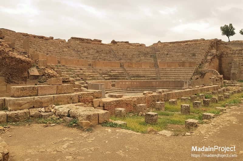
Theatre
The ancient Roman theater of Thamugadi, situated in present-day Timgad, Algeria, was carved into the slope of a small hill located to the south of the forum. Its construction aimed to accommodate a capacity of approximately 4,000 spectators. An inscription found at the site indicates that the theater was erected during the reigns of Marcus Aurelius and Lucius Verus, specifically between 161 and 169 CE. The construction was finalized in 168 CE, but centuries later, in 539 CE, the theater was partially dismantled by soldiers under the command of Justinian to obtain materials for the construction of a nearby fortress.
circa 200 CE

Trajan's Arch
The triumphal arch of Trajan is located at the west end of the decumanus, originally 12 meters high, it was partially restored in 1900. The arch is principally of sandstone, and is of the Corinthian order with three arches, the central one being 11' wide. The arch is also known as the Timgad Arch.
Constructed during the second century CE, the arch is an imposing architectural feature that exemplifies the grandeur and significance of the Roman Empire. It served as an entrance to the city, symbolizing the power and authority of Trajan's rule. The arch stands as a testament to the Roman influence in the region and the importance of Timgad as a strategic and cultural center during that era.
The Arch of Trajan in Timgad exhibits typical Roman architectural characteristics, with its triumphal arch design and decorative elements. Unfortunately, over time, the arch has suffered damage and deterioration, but its remnants still showcase the remarkable craftsmanship and artistic detail of the period.
circa

Market of Sertius
The Sertius market, also called Sertius Forum, was situated south west of the Trajan's Arch, on the decumanus maximus. The main complex of the market complex lies to the south and covers an area of approximately 1200 square meters. A lesser structure of some 95 square meters may have existed to the north, directly attached to the market.
circa

Library
circa

North Gate
circa

Decumanus Maximus
The decumanus maximus of Timgad was the main thoroughfare of the ancient Roman city. It ran wall-to-wall starting at the eastern gate and ending at the arch of emperor Trajan.


Signup for our monthly newsletter / online magazine.
No spam, we promise.
The Madain Project is an online archive of Abrahamic History and Archaeology.
Abrahamic History & Archaeology is the study of history and archaeology with respect to the three Abrahamic Faiths without considering the religious and theological aspects. The goal of Abrahamic History is to understand how and why the religious doctrines and behaviours have evlovled and changed over time. Searching for patterns in the evolution of significant cultural events such as the development of farming, the emergence of cities, or the collapse of major civilizations for clues of why and how these have influenced the three major Abrahamic religions.
Cloud Drive -
About -
Help -
Editorial Policy -
AI Policy -
Privacy Policy -
Contact
Madain Project: Encyclopedia of Abrahamic History & Archaeology.
Copyright MadainProject 2017 - 2026.
![]()
![]()
![]()
![]()
![]()
![]()