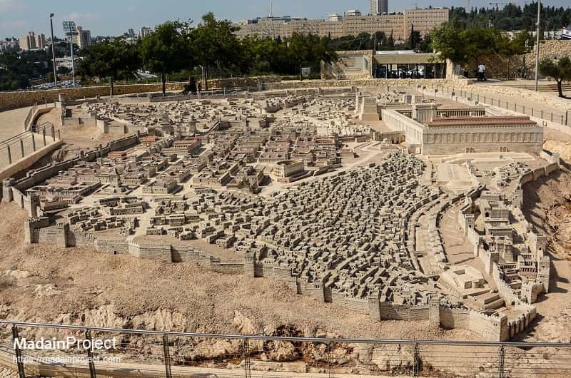
The Holyland Model of Jerusalem, or simply the Holyland Model or Model of Jerusalem in Second Temple Period, is a 1:50 scale-model of the city of Jerusalem in the late Second Temple Period. The model was moved from its original location at the Holyland Hotel in Bayit VeGan, Jerusalem, to a new site at the Israel Museum in June 2006 CE.
The Holyland Model was designed by Michael Avi-Yonah, based on the writings of Josephus Flavius, during the middle years of 1960s CE. Although it is promoted as authentic and accurate, it is more of a creative representation of the ancient city of Jerusalem during the first century CE. Nonetheless, it is one of the best depictions and reconstructions of the city in the later period of the Second Temple.
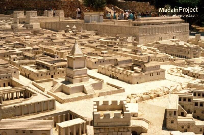
The model recreates Jerusalem in year 66 CE, the same year the revolt against the Romans erupted, resulting in the destruction of Temple and the city. The ancient city was then at it's largest, covering an area of ca. 445 acres, thus the model reflects ancient Jerusalem at its peak, just before the city was destroyed. The model of Herod's Temple in Jesus's time, also known as the Second Temple or Beit HaMikdash.
circa 66 CE
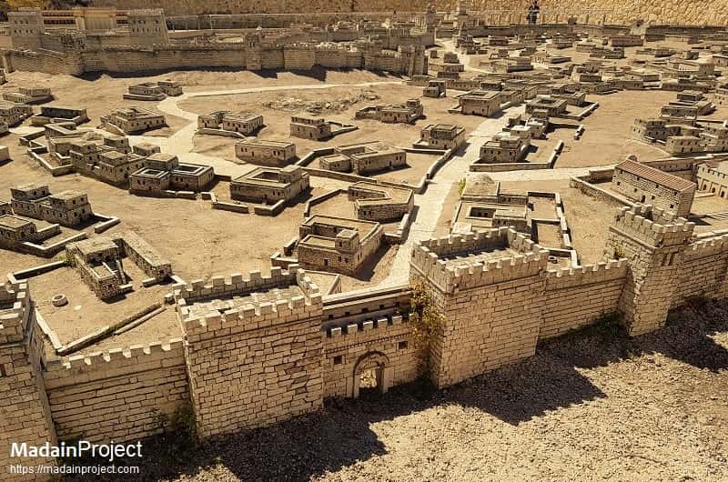
City of David
The Madina Dawud, common Arabic name: وادي حلوه, Wadi Hilweh, is an archaeological site which is speculated to compose the original urban core of ancient Jerusalem. The remains at the site include several water tunnels, one of which was built by King Hezekiah and still carries water, several pools including the Pool of Siloam known from the Old and New Testaments, and here or at the adjacent Ophel scholars expect to find, or claim to have found, the remains of the Acra.
circa 66 CE
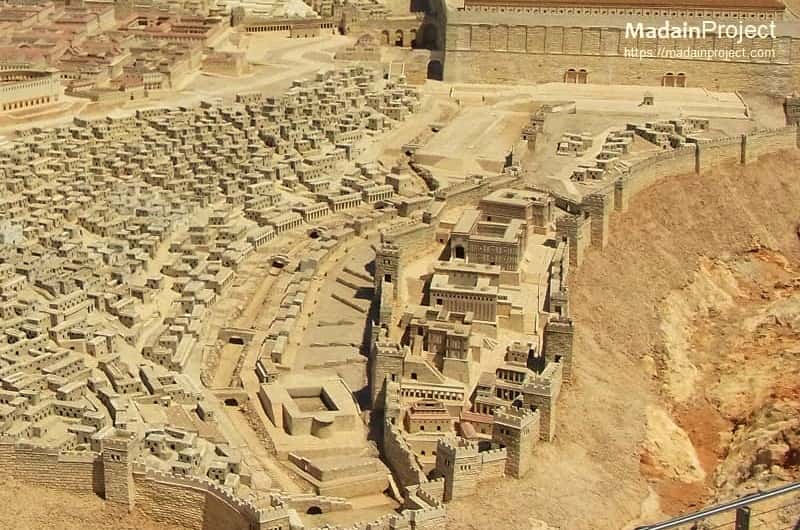
Upper City of Jerusalem
The residential area on the western hill of Jerusalem during the Second Temple Period (its area today extends over the Jewish and Armenian quarters of the Old City and Mount Zion beyond the walls, to the south) became known as the "Upper City". The name stems from the fact that it is topographically higher than the rest of the city, even the Temple Mount. It was re-planned and rebuilt in the finest Roman tradition by Herod and his successors, with blocks of large buildings separated by streets, and plazas along which palaces and public buildings stood.
circa 66 CE
Lower City of Jerusalem
The Lower City was located on the south-eastern slopes of the western hill, where the crude crowded houses of the poor were located. It is known from the Israelite era to have been known as the "Lower City". In contrast the Upper City was very wealthy and the homes were prominent, and the streets were big and broad. It was the district of Jerusalem that housed most of the common people during the first century. Built on the slope of the Western Hill, it reached into the Tyropean Valley and bordered the fortified City of David.
circa 66 CE
Bezetha (New City)
The Bezetha (Hebrew: בי חדתא), also called by Josephus the New City was a suburb of Jerusalem, north and north-west of the Temple, built opposite the tower Antonia (now in proximity to the Convent of the Sisters of Zion and Ecce Homo on Via Dolorosa Street) and extending as far as Herod's Gate westward and beyond. Originally, this part of the city was outside the area enclosed by the second wall, but during the reign of Agrippa I, had been enclosed by the newer third wall.
circa 66 CE
Ophel
The location of the Jerusalem Ophel, meaning fortified hill or risen area, of the Hebrew Bible is easy to make out from the references from 2 Chronicles 27:3; 33:14 and Nehemiah 3:26, 27: it was on the eastern ridge, which descends south of the Temple, and probably near the middle of it.
circa 66 CE
Adiabene Palaces
While speaking about the ancient first century CE Jerusalem Josephus mentions that the Queen Helene of Adiabene constructed large palace structures on the eastern hill, south of the Temple Mount and Ophel area, which correspondes to the elevated ridge today known as the fortified city of David. Josephus writes that these royal residential palace complexes were built in the Parthian (foreign) style, constructed with the mud bricks (mud and fired bricks). This construction material and the architectural style distinguished these palaces from the rest of the buildings in the city of Jerusalem to a wide extent.
circa 66 CE
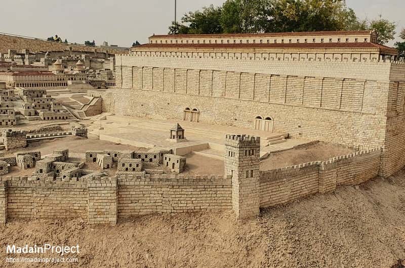
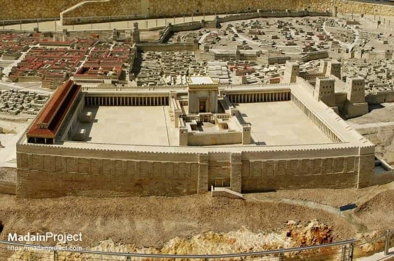
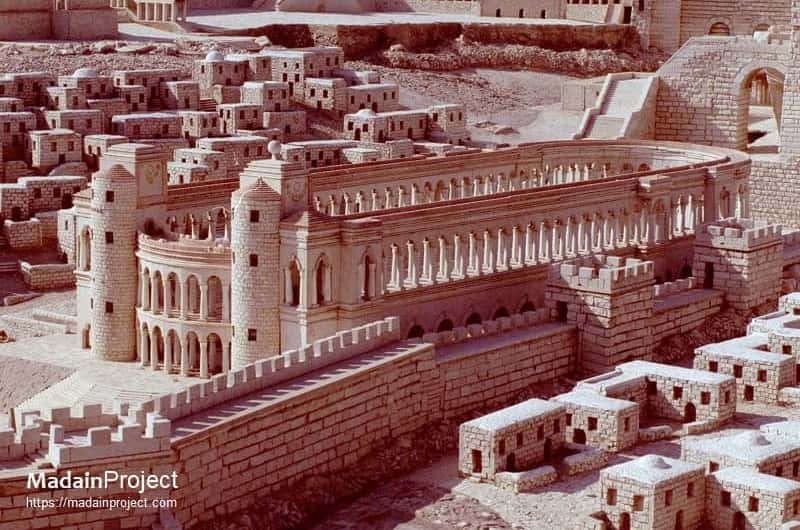
Herodian Temple Complex
The Temple Mount as depicted in the Holyland Model, shows the second Jewish Temple complex in its entirety, spanning the whole of Temple Mount Platform. According to the Jewish tradition, this reconstruction, later expanded and renovated several times specifically during the Hasmonean and Herodian periods, replaced Solomon's Temple (the First Temple), which was destroyed by the Neo-Babylonian Empire in 586 BCE, when Jerusalem was conquered and part of the population of the Kingdom of Judah was taken into exile to Babylon.
circa 10 CE
Pool of Bethesda
According to the Gospel of John, the Pool of Bethesda (locate) was a swimming bath, and was located on the eastern side of the city near the Fortress of Antonia. The name of the pool is said to be derived from the Hebrew and/or Aramaic language. Beth hesda (בית חסד/חסדא), means either house of mercy or house of grace. In the first century BCE, natural caves to the east of the two pools were turned into small baths, as part of an asclepieion.
circa 66 CE
Pool of Siloam
The Pool of Siloam (locate) was a rock-cut pool on the southern slope of the City of David, the original site of Jerusalem, located outside the walls of the Old City to the southeast. The pool of Siloam was fed by the waters of the Gihon Spring, carried there by two aqueducts. The Pool of Siloam was first built during the reign of Hezekiah (715–687/6 BCE), to provide a water supply inside the City to protect it from a siege. The pool was fed by the newly constructed Siloam tunnel.
circa 66 CE
Herodian Towers
Three of the four notable towers, from left to right: Mariamne Tower (left background), Phasael Tower (center foreground), Hippicus Tower (right background). The towers named Phasael, Hippicus and Mariamne were situated in the northwest corner of the so-called First Wall, the Hasmonean and Herodian city wall protecting the Western Hill of Jerusalem. They were situated close to where the Jaffa Gate is today and were built by Herod the Great at the same time he built his immediately adjacent royal palace.
circa 66 CE
Herodian Palace
The Palace of king Herod (locate) in Jerusalem was built during the last quarter of the first century BCE by Herod I the Great. It was the second most important building in Jerusalem, after the Temple itself, in Herod’s day and was situated at the northwestern wall of the Upper City of Jerusalem. Herod lived in it as a principal residence, but not permanently, as he owned other palace-fortresses, notably at Masada, Herodium and Caesarea Maritima.
circa 66 CE
Herodian Theater
Herod the Great built a marvelous theater (locate) in Jerusalem's Upper City. It was a large auditorium with no roof and semicircular rows of seats ascending from the center stage. Wealthy Jews came there to watch the best of Greek and Roman drama. Although Josephus mentions the theatre, archaeological remains of Herod's Theater are scarce.
circa 66 CE
Upper Market (Agora)
The upper agora (locate), the Jerusalem Agora, or the Jerusalem marketplace was not far from the Temple in the northeastern corner of the Upper City on Mount Zion. The market is believed to have been located directly adjacent (east) to the Herodian palace in Jerusalem. The area east of Herod's Palace was known as the Upper City, this is where the wealthy Jews lived. Although some recent finds suggest that the center of commercial activity may have situated to the the east near the pilgrim road, leading up to the Temple Mount from the Siloam Pool.
circa 66 CE
Hippodrome
The Jerusalem Hippodrome (locate) was one of the three known Roman structures built during the Herodian period. According to the historical tradition, towards south of the Temple, leading to the Huldah Gates near the Synagogue of the Freedmen (see note 1) was the Hippodrome, built by Herod like a Roman Circus, for horse and chariot races. Josephus mentions that the sports Hippodrome was a great amphitheatre built by Herod the Great in the plain. As the remains of the Hippodrome were not found categorically within the city, it's reconstruction has since been removed (inspect) from the Holyland Model.
circa 66 CE
Monument of King Alexander Jannaeus
The Tomb of Alexander Jannaeus (locate), the second king of the Hasmonean dynasty, who ruled over an expanding kingdom of Judaea from 103 to 76 BCE, was located Near the Pool of the Sheepmarket. He was the son of John Hyrcanus and grandson of Simon the Hasmonean (led Judaea to independence). King Alexander Jannaeus, who was also known as Jonathan the High Priest, died on the opposite side of the Jordan River and was buried in a tomb in Jerusalem. The architectural depiction in the Holyland Model is speculated.
circa 66 CE
Tomb of Huldah
The Tomb of Huldah (locate), as seen in Holyland Model of Jerusalem, is believed to have been located south of the Temple Mount in the Ophel or Acra area. The tomb belonged to the Jewish priestess Huldah, who lived and served during the period of King Josiah, the last of Judah's "good" kings (reigned 640–609 BCE). The two sets of gates in the southern wall of the Temple Mount (western Huldah Gates in the Southern Temple Mount Wall are visible in the background, were also named after the priestess. She lived in Jerusalem, in the Second District or Second Quarter, according to the Jewish tradition she was the adviser to King Josiah 2700 years ago. Although her tomb is believed and depicted in the area called Ophel, south of the Temple Mount, there is another tomb site claiming to be the site of her burial on the Mount of Olives.
circa 66 CE
Antonia Fortress
The Fort Antonia (locate) was located on the Northwest corner of the Temple Mount and called the Fortress of Antonia, named after Herod’s friend Marc Antony and another of Herod's landmarks. It stood 115 feet high and was partly surrounded by a deep ravine 165 feet wide. It functioned as headquarters for the Roman soldiers, overlooking Jerusalem, the Antonia Fortress was garrisoned with 600 Roman soldiers, who watched over the Temple courts in order to preserve order.
circa 66 CE
David's Tomb
Model of the David's Tomb (locate) as it might have looked in the first century CE, it stood behind the Palace of Caiaphas. The Holyland Model places the tomb near the upper city, adjacent to the Essene quarter which was situated between the upper city and the lower city. Today the traditional tomb of David is located on the western hill of Jerusalem (modern Mount Zion), just outside the old city. This part of the ancient city of Jerusalem lies outside the Ottoman era walls that enclose the old city.
circa 66 CE
Fish Gate
The Fish Gate, mentioned in the Book of Nehemiah (see note 2), was a gate in the north wall of Jerusalem, probably a little to the east of the current location of Damascus Gate. The Fish Gate of first century CE Jerusalem, was one of the ten gates listed by Nehemiah (governor of Persian Judea under Artaxerxes I, lived circa 473-403 BCE). The modern Damascus Gate probably replaced this earlier entrance, to the old city of Jerusalem. It was the closest gate to the fish market, and it is believed that fishermen from the Sea of Galilee and the Jordan River, Jewish and Syrian alike, used this gate to bring fish to market.
circa 66 CE
Tower of Psephenus
The tower of Psephenus or Psephinus, was located on the north-western corner of the Jerusalem's third wall. Josephus mentions the Tower Psephinus saying, "But wonderful as was the third wall throughout, still more was the tower Psephinus, which rose at its northwest angle and opposite to which Titus encamped. For, being seventy cubits high, it afforded from sunrise a prospect embracing both Arabia and the utmost limits of Hebrew territory as far as the sea." (Josephus Wars).
circa 66 CE
Shushan Gate
The Shushan Gate, today known as the Golden Gate or Bab al-Rehmah, was the only entrance to the Temple Mount from the Kidron Valley in the first century CE. The decorated gate was named after the city of Susa in ancient Persia and faced in the same eastern direction. The gate was part of the Second Jewish Temple in Jerusalem that was constructed by the Jewish people after their return from exile in Babylon after king Darius granted them permission to return and rebuilt the temple. The exact location of the ancient Shusahn gate is not known, but it is most commonly identified with the Golden Gate, although the Shushan Gate would have been situated on a much lower level.
circa 66 CE
Great Bridge of the Wilson's Arch
The bridge was situated over the Tyropoeon Valley adjacent to the Western Wall and connected the upper city ofJerusalem with the Temple Mount. The bridge also carried an aqueduct along with the foot-traffic. Archaeological excavations and the radio carbon dating suggests that initially a smaller bridge was built here between 20 BCE and 20 CE. This smaller bridge was expanded later, nearly doubling the size, between the years 30 to 63 CE. This bridge, no longer extant, is thought to have allowed direct access to a gate (no longer extant) that was level with the surface of the Temple Mount during the late Second Temple period. Although the bridge has not survived today, the arches that once supported it still remain standing and feature a number of uses including the largest arch adjacent to the Western Wall. This large arch, named Wilson's Arch, was later converted in to a synagogue. The dimensions of this bridge are not known, due to the several expansions, renovations and reconstructions over the centuries.
circa 66 CE
Tomb of John Hyrcanus
The monumental tomb of John Hyrcanus is thought to have been situated near the citadel, north and inside of the third wall. John Hyrcanus was the Hasmonean king and the high priest, his reign spanned the latter part of the second century BCE. Josephus recounts that during the siege of 70 CE, Romans attacked and broke through the fortifications near this part of the city.
circa 66 CE
Southwestern Access Staircase
The southwestern access staircase or the great staircase was a monumental stairway that provided direct access to royal stoa / market area on the Temple Mount platform from the lower market that formed part of the Herodian street along the western wall near the south-eastern corner. This staircase was part of King Harod's great expansion of the Temple complex but was completed some twenty years after his death. The remains of the monumental arch that connected the lower part of the staircase located on the western side of the Tyropoeon Valley, above the Herodian shops, to the western wall entrance that lead in to the temple complex are known as the Robinson's Arch today. This overpass was destroyed during the First Jewish–Roman War, only a few decades after its completion. It was constructed at a major ancient intersection, connecting the road coming from the south (from the Ophel area)and the road coming from the Siloam pool.
circa 66 CE
Pool of Israel
Pool of Israel, today known as Birket Israel, Birket Israil, or Birket Isra'in was a public cistern located on the north-eastern corner of the Temple Mount, in Jerusalem. The Romans are believed to have erected this structure as a water reservoir and a defensive barrier for the northern wall of the Temple Mount. Positioned within the western branch of the Kidron Valley, running through the northwest quadrant of the city, it fell into disuse as a reservoir by the mid-19th century. Over time, it became partially filled with waste and repurposed as a vegetable garden. In 1934, the area was filled in and is now recognized as el-Ghazali Square. This reservoir, which was once Jerusalem's largest, played a crucial role in the city's rainwater storage system for centuries. Additionally, it doubled as a moat, offering protection to the northern wall of the Temple Mount.
circa 66 CE
Hasmonean Palace of Jerusalem
The Hasmonean palace in Jerusalem stood on the Eastern side of the Upper City, directly opposite to the western wall and adjacent to the great bridge connecting the upper city to the Temple. It featured a structure known as the Xystus, which was used as a platform from which addresses could be made to the people in the spacious square beneath. The palace included expansive courtyards, residential areas, bathing facilities, and a service court. The depiction and the location in the Holyland model is speculative, so far no remains have been found in the archaeological record. The currenct depiction in the Holyland Model of Jerusalem is based on historical account of Josephus Flavius. During the Hasmonean period, unlike the biblical period, the Temple Mount was entirely dedicated to religious activities, whereas the palaces were located in the western (upper) part of the city. The Palace had a view of the Temple, which angered the Jews (El'baum 100).
According to Josephus; "About the same time king Agrippa built himself a very large dining-room in the royal palace at Jerusalem, near to the portico. Now this palace had been erected of old by the children of Asamoneus. and was situate upon an elevation, and afforded a most delightful prospect to those that had a mind to take a view of the city, which prospect was desired by the king; and there he could lie down, and eat, and thence observe what was done in the temple; which thing, when the chief men of Jerusalem saw they were very much displeased at it; for it was not agreeable to the institutions of our country or law that what was done in the temple should be viewed by others, especially what belonged to the sacrifices." (Josephus' Antiquities: 20.8.11)
circa 2006 CE
The model, designed by Michael Avi-Yonah, was moved from its original location at the Holyland Hotel in Bayit VeGan, Jerusalem, to a new site at the Israel Museum in June 2006 CE.
Signup for our monthly newsletter / online magazine.
No spam, we promise.
The Madain Project is an online archive of Abrahamic History and Archaeology.
Abrahamic History & Archaeology is the study of history and archaeology with respect to the three Abrahamic Faiths without considering the religious and theological aspects. The goal of Abrahamic History is to understand how and why the religious doctrines and behaviours have evlovled and changed over time. Searching for patterns in the evolution of significant cultural events such as the development of farming, the emergence of cities, or the collapse of major civilizations for clues of why and how these have influenced the three major Abrahamic religions.
Cloud Drive -
About -
Help -
Editorial Policy -
AI Policy -
Privacy Policy -
Contact
Madain Project: Encyclopedia of Abrahamic History & Archaeology.
Copyright MadainProject 2017 - 2026.
![]()
![]()
![]()
![]()
![]()
![]()


