In the Roman city planning, a decumanus was an east–west-oriented road in a Roman city or castrum (military camp). The main decumanus was the Decumanus Maximus, or most often simply the Decumanus. In a military camp this connected the Porta Praetoria (closest to the enemy) to the Porta Decumana (away from the enemy).
The Decumanus Maximus was a fundamental feature of Roman urban planning, serving as a major east-west thoroughfare in many ancient Roman towns and cities. Derived from the Latin word "decumanus", meaning tenth, it was typically the widest street in the town grid, intersecting perpendicularly with the Cardo Maximus, the main north-south street. This grid pattern formed the backbone of Roman urban design, reflecting the Romans' practical approach to city organization and infrastructure.
In Roman towns, including Jerash, Herculaneum, and Rome itself among many others across the empire, the Decumanus Maximus played a pivotal role in facilitating movement of traffic, commerce, and social interaction. Lined with shops (tabernae), workshops, public buildings, and residences, it was a bustling corridor of activity where residents conducted daily business, bought and sold goods, and engaged in social gatherings.
Archaeological excavations in almost all major ancient Roman cities have unearthed well-preserved sections of the Decumanus Maximus, providing valuable insights into Roman urban life. The street's layout, flanked by colonnades or sidewalks, and its strategic location within the town's broader infrastructure underscored its importance as a commercial and cultural artery.

circa 100 CE
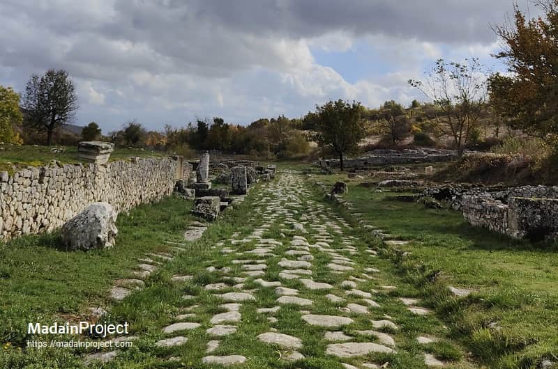
Alba Fucens Decumanus
The decumanus, also called the Via dei Miliario, of ancient Italic town of Alba Fucens lies in the western section of the currently excavated area. It has been excavated to a length of approx. 170 meters. Its modern name via dei Miliario reflects the discovery of a miliarium (milestone) found there, a small column that the Romans used to place along the main roads to indicate the distance from Rome.
circa 200 CE

Decumanus Maximus of Petra
The colonnaded street, of ancient Petra was the Decumanus Maximus street with commercial shops on both sides. It started at the foot of the eastern ridge and stretched to the Qasa al-Bint temple in the west. The so-called "colonnaded street" or the decumanus of Petra, built by the Romans after they took control of Petra in 106 CE, extended for about nine hundred meter. That year marked the end of the Nabataean Kingdom period. The city then became part of the Roman Empire’s Provincia Arabia Petraea. The ancient shops once flanking this avenue are gone or are in ruins.
A large number of notable archaeological structures remain along the Petra decumanus, including, a nymphaeum, the great temple, temenos, and a Hadrianic gate or triumphal arch.
circa 10 CE

Decumanus of Herculaneum
In Herculaneum, like in many Roman towns, the Decumanus Maximus was a vital east-west thoroughfare that structured the urban landscape and facilitated daily life. Running horizontally through the town grid, the Decumanus Maximus intersected with the Cardo Maximus, the main north-south street, forming a crucial axis of movement and commerce. Archaeological findings along the Decumanus Maximus in Herculaneum reveal well-preserved sections of colonnades, sidewalks, and remnants of buildings that once flourished with commercial and residential activities. The street's strategic positioning and architectural elements highlight the Romans' expertise in urban planning, emphasizing functionality and efficiency in their city design. Today the exposed length of the ancient road is about hundred meters.
circa 10 CE

Decumanus of Ancient Palmyra
The decumanus or the colonnaded street of ancient Palmyra was lined with colonnades and served as a central artery for traffic, commerce, social activities, and ceremonial events, connecting various key structures and districts of the city. The Decumanus was characterized by its impressive colonnades, which flanked the street on both sides, providing shelter for pedestrians and shopfronts. These colonnades were composed of Corinthian columns, adding a touch of grandeur and elegance to the urban landscape. The street itself was paved with large stone slabs, designed to accommodate the heavy traffic of carts, chariots, and pedestrians that traversed the city daily.
The decumanus in Palmyra has survived and is exposed up a kilometer, starting at the "western funerary temple" and reaching just outside the ancient monumental arch (now lost arch) of Palmyra. Archaeological excavations along the Decumanus have uncovered various artifacts that provide insights into the daily life and trade activities of ancient Palmyra. These include coins, pottery, inscriptions, and remnants of the original pavement and colonnades. These findings illustrate the city's prosperity and its significance as a trading hub.
circa 10 CE

Via dell'Abbondanza
The ancient decumanus of Pompeii, today known as the via dell'Abbondanza, was the primary road that connects the eastern and western parts of the city. The entire city was designed with a grid pattern, featuring east-west streets like this one and cardines (cardos), the north-south streets that intersected them. The layout was very orderly, with the Decumanus Maximus serving as the main thoroughfare running through the city up to the Sarnus Gate, reaching the boundary with the countryside and the river.
The Pompeian decumanus started just outside the Porta Sarno (Sarnus Gate) in the east and ran westwards for a length of about nine hundred meters, interrupted by the forum for about forty meters and then continues west until it reaches just outside the Porta Marina. Total length of the decumanus maximus at Pompeii is around 1060 meters (excluding the width of the forum).
circa 10 CE

Decumanus of Gerasa
The city of Gerasa featured two principal east-west streets, or decumani, which intersected the north-south Cardo Maximus. The South Decumanus, which joined the Cardo at the South Tetrakionion plaza, was repaved around 170 CE and stretched for approximately 620 meters. Its 7-meter-wide carriageway was flanked by porticoes with 6-meter-high columns bearing Corinthian capitals, though it notably lacked footpaths. Further north, the North Decumanus featured a wider, more elaborate design, with a 9-meter-wide roadway paved with diagonally laid limestone slabs and sidewalks over 4 meters wide. It was also lined with colonnades, some featuring Ionic columns. Entrances along its southern side suggest it was lined with shops, reflecting the street's role as a commercial corridor. Unlike the well-preserved Cardo, parts of the decumani remain less known and are still areas of archaeological investigation.
circa 10 CE

Hippos Decumanus
The decumanus maximus of ancient Hippos is exposed up to a length of some 270 meters, starting with the Roman Empire period forum in the west. The Decumanus Maximus was the main thoroughfare of the Roman city of Hippos (Sussita), running east-to-west across the summit of the mountain. Stretching approximately 550 meters long and 4.2 meters wide, the street connected the eastern city gate to the Roman forum on the west. This colonnaded road was paved with basalt flagstones quarried locally, and its sidewalks were lined with columns of the same material. Its grid pattern, which included perpendicular cardines (north-south streets), defined the urban layout of Hippos, which reached the peak of its prosperity in the second century CE. Excavations have revealed a more well-preserved eastern section of the street, while the paving stones of the western part were mostly removed after the city was destroyed by the major earthquake of 749 CE. Recent archaeological work has further refined its dating, suggesting the Decumanus Maximus was laid out as early as the first half of the first century CE.
circa 10 CE

Decumanus Maximus at Lepcis Magna
Lepcis Magna's urban layout was influenced by its pre-Roman origins, meaning it did not have a rigidly planned Decumanus Maximus from its inception like some other Roman colonies. Instead, an ancient road that served as a major thoroughfare along the North African coast was gradually integrated into the city as it grew, especially during the first and second centuries CE. This street, which today is referred to as the Decumanus, was marked by a simple milestone about 350 meters outside the original city walls at the intersection with the Cardo. This location would later be dominated by the Arch of Septimius Severus, a native son of Lepcis Magna who lavished attention on his hometown. The Arch of Marcus Aurelius was also built over this road, and other unexcavated monuments are thought to line this section of the city. The Decumanus, therefore, represents the evolution of Lepcis Magna, from its status as an ancient settlement to a flourishing Roman metropolis, with the incorporation of grand Roman monuments along what was once an old coastal road.
circa 10 CE

Ostia Antica Decumanus
The Decumanus Maximus was the main east-west street of Ostia Antica, serving as the continuation of the Via Ostiensis that connected the city to Rome. Entering through the Roman Gate, the Decumanus was a busy commercial corridor lined with a variety of establishments, including shops, guild seats, and apartments, particularly during the city's peak as Rome's primary port. Along its eastern half, inscriptions known as the Cippi of Caninius marked public land designated for port-related commerce. The road's western end split into two branches: one continuing as the Decumanus toward the Marine Gate, and the other, the Via della Foce, heading toward the mouth of the river Tiber. A triumphal arch built by Emperor Caracalla once spanned the street near the theater, and archaeological evidence, in the form of wheel ruts, suggests that vehicular traffic was restricted past this point into the city center. The thoroughfare passed prominent landmarks, including the theater and the bustling Forum, before branching off toward the harbor and the sea.
circa 10 CE

Timgad Decumanus
The Timgad decumanus originally ran east-west for a length of approx 320 meters, starting at the eastern gate and ending at the Arch of Trajan. However, after the expansion of the city, the decumanus of Thamugadi continued for another 350 meters towards the north-west. The original stretch inside the square city was in a straight line, but the it bent towards the north-west and terminated at the north-western gate. The entire length of the Timgad decumanus stretched for some 670 meters. The cardo maximus branched off from the decumanus at the at 173 meters mark from the east.
circa 10 CE

Battus Street (Cyrene)
The street named for Battus I, the founder and first king of the Greek colony of Cyrene (founded circa 630 BCE), served as a vital thoroughfare connecting the city's ancient marketplace and his tomb to the Sanctuary of Apollo. As the leader of Greek immigrants from the island of Thera / Akrotiri, Battus established the Battiad dynasty that ruled for eight generations and oversaw Cyrene's early prosperity. Archaeological discoveries indicate that this key route was part of the upper city, which also included a forum and basilica. Honoring the revered founder, the street was not only a functional road but also part of the sacred landscape, linking the city's commercial and civic heart with its most important religious sanctuary. A statue of Battus I was even dedicated at Delphi by his subjects, depicting him in a chariot driven by a nymph, with Libya crowning him king.
circa 100 CE
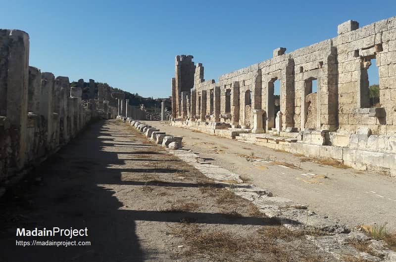
Western Colonnaded Street of Perga
The Western Colonnaded Street of Perga, one of the city's two main arteries, is a roughly 460-meter-long, 8-meter-wide thoroughfare that runs from the main street intersection toward the Palaestra and Northern Baths. Lined with Corinthian or Ionic columns, these porticoes provided pedestrians with shaded walkways and served as a location for shops. Archaeologists conducting excavations along this route have revealed evidence of seismic damage and subsequent repairs, as well as the floors of the shops, including a notable mosaic depicting Agamemnon's sacrifice of Iphigenia. The opening of this street as a tourist route has provided visitors with a clear path toward other northern landmarks, such as the Northern Baths, completing a key section of the ancient city's urban plan.
Signup for our monthly newsletter / online magazine.
No spam, we promise.
The Madain Project is an online archive of Abrahamic History and Archaeology.
Abrahamic History & Archaeology is the study of history and archaeology with respect to the three Abrahamic Faiths without considering the religious and theological aspects. The goal of Abrahamic History is to understand how and why the religious doctrines and behaviours have evlovled and changed over time. Searching for patterns in the evolution of significant cultural events such as the development of farming, the emergence of cities, or the collapse of major civilizations for clues of why and how these have influenced the three major Abrahamic religions.
Cloud Drive -
About -
Help -
Editorial Policy -
AI Policy -
Privacy Policy -
Contact
Madain Project: Encyclopedia of Abrahamic History & Archaeology.
Copyright MadainProject 2017 - 2026.
![]()
![]()
![]()
![]()
![]()
![]()