The Decumanus Maximus of Petra (also called the colonnaded Street) runs through the center of Petra proper, with many un-excavated sites on either side. It was the principal east–west thoroughfare of the ancient Nabataean city, which later incorporated Roman urban design principles following the annexation of the Nabataean Kingdom in 106 CE. It follows the standard Roman pattern of an east–west decumanus, but without the normal cardo maximus (north–south axis).
The decumanus of Petra illustrates the integration of Nabataean topography with Roman architectural and infrastructural norms. Unlike the grid systems of Roman colonial cities, Petra’s decumanus adapted to the city’s rugged terrain, running through the Siq and the open areas of the lower city before reaching the monumental precincts. Lined with colonnaded porticoes in the typical Roman architectural style, the street facilitated pedestrian circulation and the movement of goods, linking marketplaces, administrative buildings, and religious structures. Excavations and archaeological surveys reveal traces of paving stones, drainage systems, and monumental façades along the decumanus, indicating a deliberate effort to harmonize functionality with aesthetic expression.
The remains of colonnade street in city proper, Petra, looking towards the arched gate. It leads from main theater to the Qasr al Bint (visible in the background), the ancient shops that once flanked this avenue are gone or are in ruins. The street represents an original Nabataean creation,later refurbished during the period of Roman occupation. It would have been one of the principal shopping streets of ancient Petra. The street was rebuilt in 106 BCE with a width of 6 meters.

circa 200 CE

Standing in front of the great temple (stairs to the right lead to the temple entrance) view towards the royal tombs. This is believed to have been the heart of the city and center of various types of commercial activities and transactions during the third century BCE. The street continued to be used throughout the Byzantine period during the fourth and fifth centuries, until the sixth. The street was paved in horizontal and vertical ways in order to facilitate the movement of vehicles as it curved from the middle to allow the draining of water, which is equipped with a network of channels under the street level.
circa 25 BCE- 75 CE

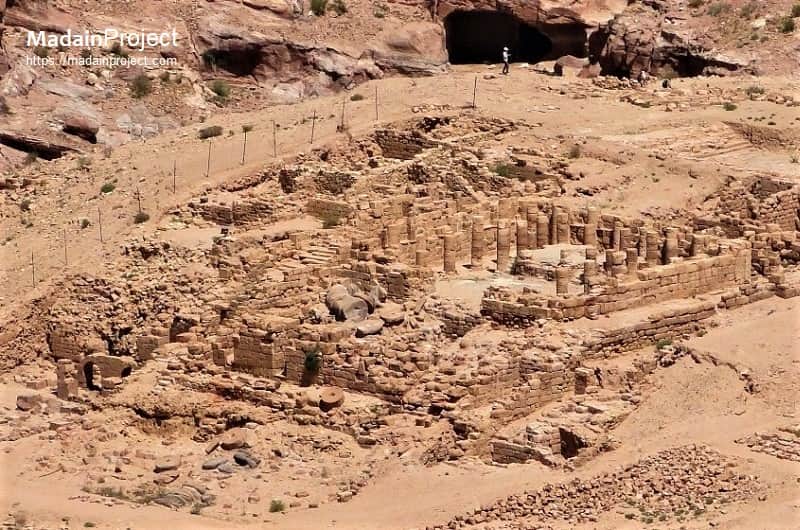
Great Temple of Petra
The great temple precinct is estimated to cover 7,000 square meters (76,000 square feet) and it comprised north south of Propylaea monumental entryway (a lower temenos) sacred area: twin exedra (semi-circular structures) flanked by broad stairways: and an upper temenos – the sacred enclosure for the temple itself. The style and quality of the Temple`s elaborate floral friezes and acanthus-laden limestone capitals suggest that the sanctuary was constructed by the end of the first century BCE by the Nabataean
circa 9 BCE- 40 CE

Qasr al-Bint
The Nabataean temple of Qasr al-Bint, also known as the Temple of Dushara, stands as the most venerable and best-preserved free-standing masonry structure within the UNESCO World Heritage site of Petra. Constructed in the late 1st century BCE, likely during the reign of King Aretas IV (9 BCE–40 CE), the temple served as the primary cultic center of the Nabataean capital. Architecturally, the monument is a nearly square building set upon a three-meter-high podium of rubble core and ashlar masonry, reached by a monumental white marble staircase of 27 steps. Its design follows a tripartite adyton plan, featuring a pronaos (vestibule) originally framed by four massive Corinthian columns, a naos (chamber), and a central cella that housed the deity's image.
A defining engineering characteristic of Qasr al-Bint is the integration of horizontal wooden string courses—identified as Lebanese Cedar—within its 23-meter-high walls, a technique that enhanced seismic resistance and allowed the structure to withstand major earthquakes that leveled other buildings in the city. While scholarly debate continues regarding its exact dedication, the temple's northern orientation toward a sacrificial altar suggests its association with the chief god Dushara and possibly the goddess al-Uzza. Following the Roman annexation in 106 CE, the site was remodeled for the imperial cult before its eventual destruction by fire in the late 3rd century CE. Today, the monument remains a focal point of archaeological study, with recent 2025 research highlighting its complex history of reuse and ongoing efforts to stabilize its monumental sandstone facades.
circa 27 CE
Temple of the Winged Lions
The Temple of Winged Lions, a significant Nabataean ritual complex situated on the northern slope of the Wadi Musa in ancient Petra, dates to the early first century CE (circa 27 CE) during the reign of King Aretas IV. Architecturally, the sanctuary is characterized by its tripartite layout, featuring a monumental ascending entryway, a colonnaded porch, and a central cella (inner chamber) measuring approximately 17.5 by 17.5 meters.
The structure derives its name from unique Nabataean-floral capitals adorned with winged feline figures that originally crowned the twelve columns surrounding a square elevated altar platform, or motab. Archaeological excavations led by Philip C. Hammond (1974–2005) revealed that the interior was once lavishly decorated with polychromatic painted plaster and elaborate stucco moldings, including a notable "eye-stele" inscribed with a dedication to the goddess al-Uzza. An atypical feature of the complex is its integration of industrial facilities, such as workshops for marble processing and pigment grinding, suggesting the temple functioned as a self-sustaining economic entity as well as a cultic center.
Although largely destroyed by the earthquake of 363 CE, the site remains a focal point for modern conservation efforts under the Temple of the Winged Lions Cultural Resource Management (TWLCRM) Initiative, which continues to implement stabilization projects and sustainable heritage practices as of 2025.
circa 106 CE
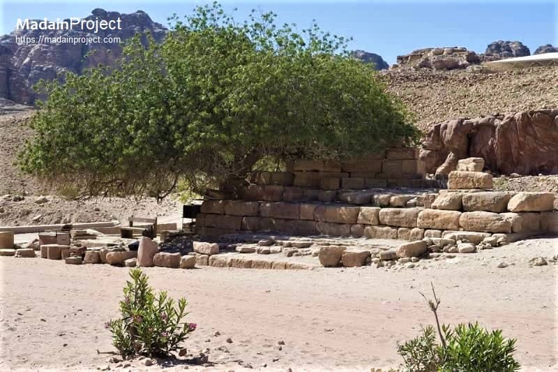
Nymphaeum
The remains of the Roman era Nymphaeum are at the beginning of the colonnaded street at Petra. It was situated at the confluence of two watercourses, dedicated to the water nymphs and was probably one of the improvements made to the city after the Roman annexation. It is a semi-circular public fountain near the junction of Wadi Musa and Wadi al-Mataha and six Nabataean columns decorated the façade. Virtually nothing remains of the ancient superstructure, and even the retaining wall is modern.
the monumental public fountain situated at the eastern terminus of the Colonnaded Street, served as both a functional water repository and a significant civic ornament in the city’s urban center. Constructed following the Roman annexation in 106 CE, the structure was strategically located at the confluence of the Wadi Musa and Wadi al-Mataha, dedicated to the water nymphs of classical mythology. Architecturally, the Nymphaeum featured a large semi-circular exedra elevated on a stepped podium, once adorned with six Nabataean columns and intricate porticos. Water was supplied via an sophisticated hydraulic system of terracotta pipes and channels that diverted flow from springs such as Ain Mousa, emptying into a shallow basin for public consumption and aesthetic display. Although only the lower masonry levels remain today—shaded by a centuries-old pistachio tree (Pistacia atlantica)—the site remains a testament to the Nabataeans' mastery of hydraulic engineering and the integration of Graeco-Roman architectural forms into their desert metropolis.
circa 130 CE

Hadrianic Gate
The Hardrian's Gate, also frequently designated as the Temenos Gate, serves as the monumental ceremonial entrance to the sacred precinct of the Qasr al-Bint temple at the terminus of Petra’s Colonnaded Street. Likely constructed in the early 2nd century CE to commemorate the visit of the Roman Emperor Hadrian in 130 CE (or early 131 CE) during his second major tour of the eastern Roman provinces, the structure exemplifies the architectural syncretism typical of the Roman province of Arabia Petraea.
This free-standing, triple-arched gateway originally featured three massive passages flanked by engaged pilasters and was adorned with intricate stone reliefs that integrated classical Greco-Roman motifs with traditional Nabataean decorative elements, such as square ornamental reliefs. Archaeological evidence, including stone panels depicting figures such as the Greek muse Melpomene, underscores the gateway's role in delineating the secular urban center from the sanctified temenos. Despite the deleterious effects of seismic activity and erosion, the gate remains a critical datum for understanding the period of political and artistic compatibility between the Nabataean Kingdom and Roman Empire following the annexation of the city in 106 CE.
Undated

Older Street
The excavations indicates that there was an older road with 1-2 floor building, lying on its side. On the left of the portico street to the south, there is a set of stairs that leads to the courtyard, which is called the market. During the past centuries, frequent flash floods have left the Colonnade Street of Petra virtually vanished, along with most of the central Petra.
Signup for our monthly newsletter / online magazine.
No spam, we promise.
The Madain Project is an online archive of Abrahamic History and Archaeology.
Abrahamic History & Archaeology is the study of history and archaeology with respect to the three Abrahamic Faiths without considering the religious and theological aspects. The goal of Abrahamic History is to understand how and why the religious doctrines and behaviours have evlovled and changed over time. Searching for patterns in the evolution of significant cultural events such as the development of farming, the emergence of cities, or the collapse of major civilizations for clues of why and how these have influenced the three major Abrahamic religions.
Cloud Drive -
About -
Help -
Editorial Policy -
AI Policy -
Privacy Policy -
Contact
Madain Project: Encyclopedia of Abrahamic History & Archaeology.
Copyright MadainProject 2017 - 2026.
![]()
![]()
![]()
![]()
![]()
![]()