Cardo was the Latin name given to a north-south street in ancient Roman cities and military camps as an integral component of city planning. The cardo maximus, or most often simply the cardo, was the main or central north–south-oriented street. The cardo maximus was the "hinge" or axis of the city, derived from Greek καρδίᾱ, kardia — 'heart' and as such was generally lined with shops and vendors, and served as a hub of economic life.
The cardo maximus, a central feature in Roman urban planning, not only exemplifies the sophistication but also the foresight of Roman architecture. This primary north-south thoroughfare, in conjunction with decumanus maximus, formed the backbone of many Roman cities, designed to facilitate movement, trade, and social interaction. It was not merely a road but a symbol of order and civilization, reflecting the Roman commitment to creating structured, efficient, and aesthetically pleasing urban environments.
At the heart of its design, the cardo maximus intersected with the decumanus maximus, the principal east-west street, creating a grid that divided the city into manageable blocks or insulae. This grid system allowed for systematic development and easy navigation, ensuring that every part of the city was accessible. The intersection of these two main roads often became the location for the forum, the center of political, economic, and social life. The strategic placement of these roads and their intersections facilitated the organization of public spaces, commercial zones, and residential areas.
The cardo maximus was typically flanked by colonnades, providing covered walkways for pedestrians. These colonnades were more than architectural features; they were multifunctional spaces that housed shops, markets, and stalls, making the cardo a bustling commercial hub. The columns, often made of durable materials like limestone or marble, supported roofs that protected citizens from the elements, enabling vibrant street life regardless of the weather. This thoughtful design promoted economic activity and community interaction, essential components of urban life.
Public buildings and monuments frequently (though not always) lined the cardo maximus, highlighting its importance as a civic and cultural axis. Temples, basilicas, and public baths were strategically placed along these streets, ensuring that essential services and amenities were within easy reach. These structures were not only functional but also symbolic, representing the wealth, power, and sophistication of the city. The grandeur of the cardo maximus, with its impressive architecture and bustling activity, showcased the urban prosperity and advanced planning of Roman cities.

circa 100 CE

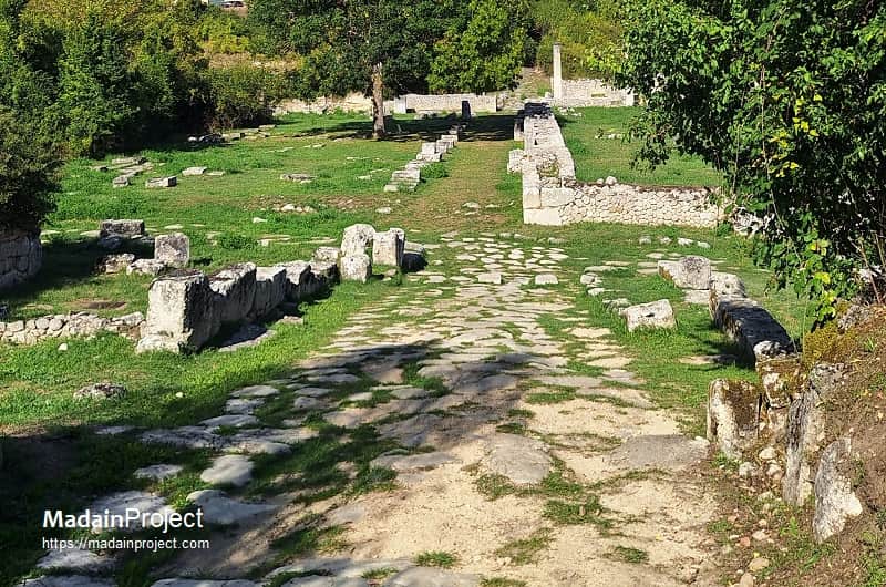
Lechaion Road (Corinth Cardo)
Lechaion Road, also known as the Corinth Cardo, was a significant ancient roadway that connected the city of Corinth to its western port, Lechaeum, located on the Corinthian Gulf. This road played a crucial role in the economic and strategic development of Corinth, facilitating trade and transportation between the city and the sea. Lechaion Road was part of Corinth's urban planning and infrastructure, contributing to its status as a major commercial center in ancient Greece. The road was lined with important public buildings, temples, and shops, reflecting the city's wealth and cultural sophistication. It was a vital artery for the movement of goods, people, and ideas, allowing Corinth to thrive as a hub of trade in the Mediterranean. Archaeological excavations along the route have revealed remnants of various structures, including monuments, fountains, and other public facilities that served the needs of the city's inhabitants and visitors.
circa 100 CE
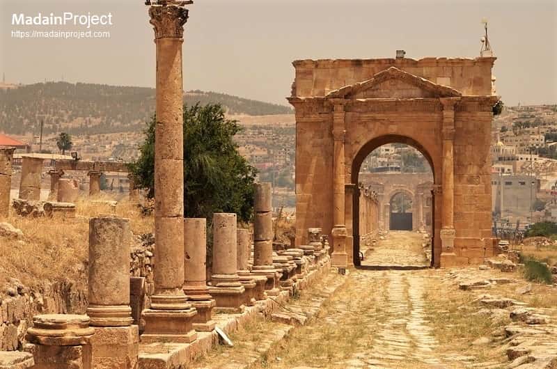
Gerasa Cardo
The Cardo Maximus of Gerasa (modern-day Jerash in Jordan) is one of the best-preserved examples of Roman urban planning in the Near East. Gerasa was a prominent city in the Decapolis, a group of cities with strong Greco-Roman cultural influences, and the Cardo Maximus served as the main north-south street, playing a vital role in the city's infrastructure, commerce, and social life.
The Cardo Maximus ran through the heart of ancient Gerasa, stretching for about 800 meters. It was aligned with the city's main north-south axis, typical of Roman urban planning. The street intersected with the decumanus maximus, the principal east-west street, forming a grid pattern that facilitated organized urban development and efficient traffic flow. Along the Cardo Maximus were several important public buildings and monuments, including the Nymphaeum (a monumental fountain), the South Theater, and various temples. These structures highlighted the city's civic and religious life. The Oval Plaza, located at the southern end of the Cardo Maximus, was an impressive open space that served as a focal point for public gatherings and ceremonies.
circa 100 CE

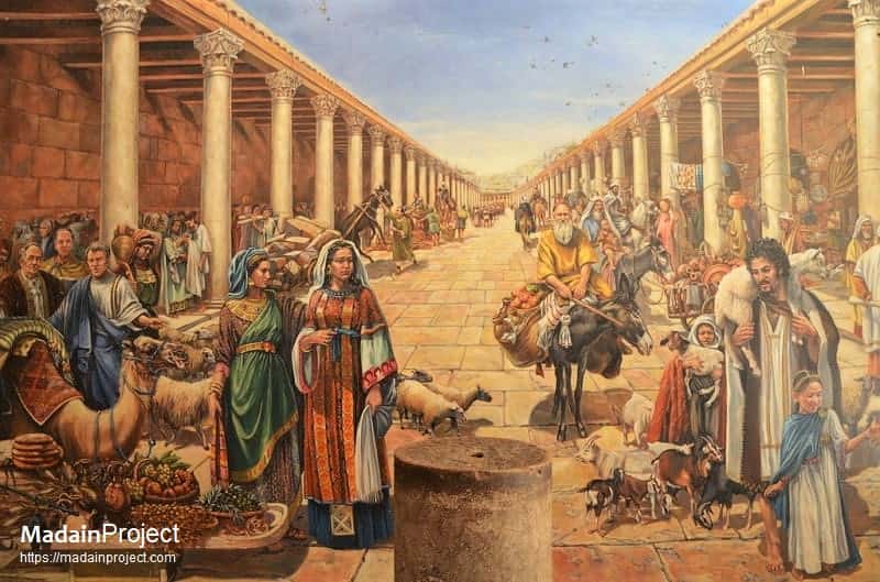
Jerusalem Cardo Maximus
The Jerusalem Cardo was the major thoroughfare in Roman and Byzantine period city of Jerusalem, serving as the primary north-south axis of the city's urban grid. This street was part of the systematic Roman planning introduced when the city was restructured by emperor Hadrian in the second century CE and later expanded during the Byzantine period. The Cardo Maximus was established as a central street running from the northern gate (Damascus Gate) to the southern part of the city.
During the Byzantine era (fourth until seventh centuries CE), the Cardo Maximus was extended and further developed. The street became an even more vital artery for commerce and daily activities, reflecting Jerusalem's (now the Old City) status as a major center of pilgrimage and trade. The Cardo Maximus was an essential feature of urban life in Jerusalem, facilitating movement, commerce, and social interaction.
circa 100 CE

Apamea Colonnaded Cardo
The Cardo Maximus of Apamea, an ancient city located in present-day Syria, stands as one of the most impressive examples of Roman urban planning and architecture. Apamea was an important cultural and economic center in the Roman Empire, and its Cardo Maximus played a crucial role in the city's layout and daily life. The Cardo Maximus served as the main north-south street in Apamea, stretching for approximately 2 kilometers. This grand thoroughfare was a vital part of the city's grid pattern, intersecting with the decumanus maximus (the main east-west street) and other secondary streets. The street was designed to connect key parts of the city, facilitating movement and access to various public and private buildings.
The Cardo Maximus was flanked by impressive colonnades on both sides, creating covered walkways for pedestrians. These colonnades consisted of hundreds of columns, many of which were made from limestone and marble, showcasing the city's wealth and architectural prowess. The street was paved with large stone slabs, ensuring a durable surface for carts and foot traffic. The high-quality paving indicates the importance of the Cardo Maximus in the city's infrastructure.
Along the cardo maximus, numerous significant public buildings and monuments were situated, including temples, basilicas, and marketplaces. These structures were strategically located to emphasize the street's role as a central axis of civic life. Notable landmarks included the Great Colonnade, a long stretch of columns that provided shade and shelter for merchants and citizens, and various monumental arches that marked key intersections along the street.
circa 100 CE

Herculaneum Cardos
In ancient Herculaneum, so far three cardos have been partially excavated. These were the principal north-south streets that formed an essential part of the city's grid layout, typical of Roman urban planning. These cardos, along with the decumani (east-west streets), organized the city into a structured and navigable grid, facilitating movement, commerce, and social interaction.
The three cardos exposed in Herculaneum are designated as the Cardo III, Cardo IV and Cardo V, which are further subdivided in to two parts each. The northern stretch of each cardo is designated as the superiore (upper) and the southern stretch is called infiriore (lower).
circa 200 CE

Beit Shean Cardo
The Cardo of Beit She'an, also known as Scythopolis during the Roman and Byzantine periods was one of the ten cities of the Decapolis, a group of cities with strong Greco-Roman cultural influences. The Cardo Maximus in Beit She'an was a main north-south street, typical of Roman city planning. It was designed to facilitate movement, commerce, and social interaction. The street was intersected by the crescent shaped Decumanus Maximus on the northern end, which was the principal east-west road, forming a grid pattern that organized the city's layout. The Cardo was flanked by colonnades on both sides, providing covered walkways for pedestrians. These colonnades also housed various shops and businesses, making the street a bustling commercial hub.
The colonnades were adorned with impressive columns and architectural elements, showcasing the city's prosperity and Roman influence. The Cardo was paved with large stone slabs, which facilitated the movement of carts and pedestrians. The quality of the paving stones reflects the importance of the street. Advanced infrastructure, including drainage systems, was integrated into the street design to manage rainwater and maintain cleanliness.
circa 100 CE

Cardo Maximus of Berytus
The Cardo Maximus was the primary north-south thoroughfare in Roman Berytus, known today as Beirut in modern Lebanon. Archaeological excavations have uncovered a 100-meter-long section of this significant street. This section is flanked by two rows of limestone pedestals that once supported 6-meter-high columns. These columns held up roofed colonnades on either side of the street, providing shaded walkways for pedestrians. A stairway within the eastern colonnade led to a large building complex, suggesting that the Cardo Maximus was an important connector between various critical areas of the city.
This principal street linked the forum, the civic heart of the city, to another extensive complex that spanned from the location of the present al-Azariyeh building to Riad al-Solh Square. During the archaeological digs, two distinct levels of the street were uncovered. The earliest level dates back to the second century CE, while a later, wider version of the street was constructed in the 4th century CE. Both phases of the Cardo Maximus featured colonnades with floors adorned with intricate mosaic pavements. In the 6th century CE, these mosaics were covered with a thin layer of white lime plaster, a renovation that indicates continued use and maintenance of the street. Despite these changes, parts of the original mosaic floors remained in use until the 19th century CE. Over time, Roman columns were repurposed in the foundations of newer buildings that were constructed within the pavement of the Cardo, effectively reducing what was once the main thoroughfare of Roman Berytus to a narrow alley.
circa 100 CE

Gadara Cardo
The Gadara Cardo, or the Cardo Maximus of Gadara, was a central north-south thoroughfare in the ancient city of Gadara, located in what is now modern-day Jordan. Gadara, known for its Hellenistic and Roman influences, was an important city in the Decapolis, a group of ten cities that were centers of Greco-Roman culture and commerce in the region.
circa 100 CE

Cardo of Pisidian Antioch
The Cardo of Pisidian Antioch was a major north-south street in the ancient Roman city of Antioch in Pisidia, located in what is now Turkey. Pisidian Antioch was founded by the Seleucid King Antiochus I in the third century BCE and later became a significant Roman colony. The Cardo maximus of ancient Pisidian Antiocheia is exposed to a length of approx. 430 meters. A number of notable buildings stood along the cardo, including a nymphaeum, market square, central church, Tiberius square, propylon, and the temple of Augustus (emperor Augustus). Other than these structures the cardo was likely lined with colonnades as in other Roman cities, of which almost nothing survives. However, wxcavations in Pisidian Antioch have uncovered remnants of the Cardo, including pavement stones, columns, and fragments of buildings.
The cardo maximus at Pisidia was part of the grid plan used by Hippodamus of Miletus (circa fifth century BCE) and illustrates successful Roman urban planning. The cardo started at the northern large nymphaeum and went southwards from there. It intersected the decumanus maximus perpendicularly at approximately seventy meters south of Tiberius' square. On each side of the cardo, some infrastructure still remains, such as shops and drainage system that dates back to the first and the second centuries CE.
circa 100 CE

Roman Utica
The Roman cardo maximus at Utica was the principal north-south thoroughfare of the city's orthogonal grid plan. This main street was a defining feature of the city's Roman phase, which began after Utica sided with Rome during the Third Punic War and was later designated the capital of the Roman province of Africa. This street plan was an urban reorganization that replaced many earlier Republican-era and Punic structures, demonstrating the city's full integration into the Roman imperial framework. While the port of Utica eventually silted up due to river deposits, the street grid and public buildings, including remnants of the forum and opulent houses with mosaic floors, provide evidence of the city's Roman Empire-era prosperity, much of which was centered on this main artery.
circa 100 CE

Leptis Magna Cardo
In Leptis Magna, the Cardo Maximus was a broad avenue lined with a number of notable buildings. Flanked by shops, markets, and administrative buildings, this central artery was not only a commercial and social hub but also a symbolic axis that connected the city's civic and religious spaces.
Archaeological excavations and historical records reveal that the Cardo Maximus was adorned with statues, fountains, and public monuments, further enhancing its grandeur and reinforcing the city's imperial identity. The careful alignment of buildings and streets along this axis reflected Roman ideals of order, efficiency, and urban planning, ensuring both functional efficiency and aesthetic harmony.
At intervals along the Cardo Maximus at Lepcis Magna, monumental gateways or arches, such as the Arch of Septimius Severus, Arch of Tiberius, and other structures punctuated the skyline, serving as iconic landmarks and symbols of imperial power and civic pride. These architectural elements not only beautified the thoroughfare but also served practical purposes, marking important intersections and entrances to the city's key districts. The section of the cardo between the arch of emperor Septimius and arch of emperor Trajan was called the Via Trionfale (street of the triumph).
The cardo of Leptis Magna was not laid in a straight line, it bent eastwards a bit about ten meters before the arch of Tiberius and then again bent northwards at the Byzantine Gate (originally a triumphal arch).
circa 100 CE
Alba Fucens Cardo
The cardo maximus in the Italic town of Alba Fucens has been traced and excavated to a length of approx. 210 meters. Currently it starts from the Porta Massima (one of the major western gates of the city) and runs eastward. A number of notable structures, including the basilica and a public colonnade or stoa, were built along the street. The cardo ran along the western edge of the Roman period forum of Alba Fucens.
circa 100 CE

Pompeii Cardo (Via Stabiana)
The Pompeian Cardo, today known as the Via Stabiana, connected to Via del Vesuvio, entered the city through Porta Vesuvio in the north and led to Porta Stabia in the south, the city's oldest gate.
Along this road several large public and private buildings were situated; including the Stabian Baths, the oldest thermal baths in Pompeii, which occupied an entire insula. The road also hosted various shops (tabernae), and directly opposite the baths was the Pistrinum di Modesto, where wheat was milled.
Millstones made from lava stone are still visible in this area. A bit further along the street stood the Temple of Jupiter Meilichios, the smallest temple in the city, which contained two large statues: one of Jupiter and another of Juno, along with a bust of the Goddess Minerva. Via Stabiana was a crucial trade route, leading to the harbor and serving as a key point for the exchange of goods and cultures.
circa 100 CE
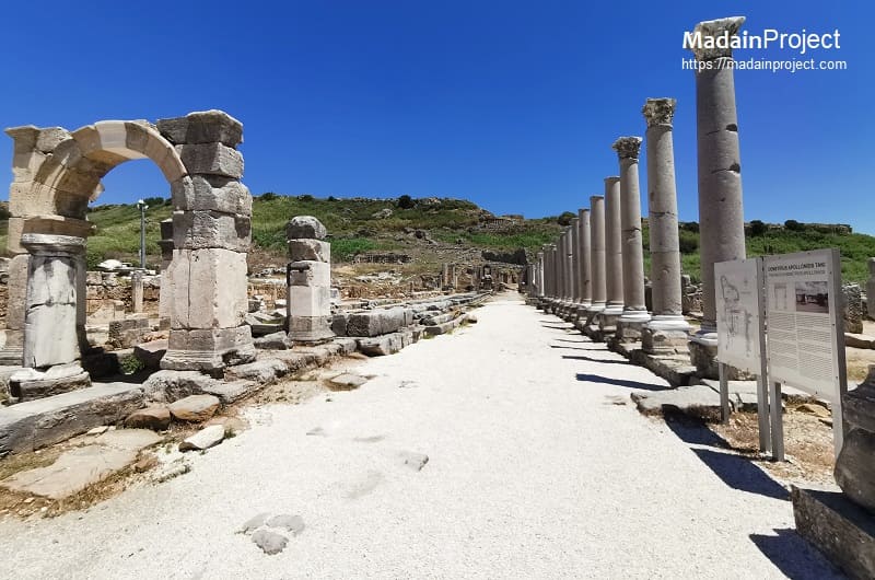
Perge Cardo Maximu
The cardo of ancient Perga, the so-called colonnaded street, extended for neary 500 meters from Hadrian's Arch in the south to the Kestros Nymphaeyum at the foot of the slope of the acropolis in the north. The street was nearly 22 meters wide, suitable for cart-traffic as well as foot-traffic. The porticoes of the Perga colonnade street have mosaic flooring featuring geometric patterns made of colourful tesserea of limestone, marble and terracotta. The colonnaded cardo of Perge featured shops at the back, which measured approx. 5 meters and had profiled door-frames 2.5 meters high and 0.5 meters deep and lintels measuring approx. 3 meters. There is a unique open water channel in the middle of the street that extended with the descending ground level from north to south carrying water from the Nymphaeum of Kestros.

Signup for our monthly newsletter / online magazine.
No spam, we promise.
The Madain Project is an online archive of Abrahamic History and Archaeology.
Abrahamic History & Archaeology is the study of history and archaeology with respect to the three Abrahamic Faiths without considering the religious and theological aspects. The goal of Abrahamic History is to understand how and why the religious doctrines and behaviours have evlovled and changed over time. Searching for patterns in the evolution of significant cultural events such as the development of farming, the emergence of cities, or the collapse of major civilizations for clues of why and how these have influenced the three major Abrahamic religions.
Cloud Drive -
About -
Help -
Editorial Policy -
AI Policy -
Privacy Policy -
Contact
Madain Project: Encyclopedia of Abrahamic History & Archaeology.
Copyright MadainProject 2017 - 2026.
![]()
![]()
![]()
![]()
![]()
![]()