Cardo Maximus of Jerusalem was the main north-south thoroughfare originally built by emperor Hadrian in Aelia Capitolina (Roman name for the region of Israel/Palestine). The Cardo Maximus, was originally a paved avenue approximately 22.5 meters wide (roughly the width of a six lane highway) which ran southward from the site of the Damascus gate, terminating at an unknown point.
The term cardo derives from the Latin cardo maximus, denoting the main axis of Roman urban planning, which functioned as a central commercial, social, and civic artery. The Jerusalem Cardo extended from the Damascus Gate in the north to the vicinity of the Temple Mount in the south, and was typically lined with colonnades and shops. Archaeological excavations have revealed successive phases of construction, reflecting the city's transformation under Roman, Byzantine, and early Islamic administrations. The Cardo’s remains constitute a key element in the study of Jerusalem’s urban morphology, illustrating the integration of Roman urban design principles into the city’s preexisting topography and its enduring significance as a center of commercial and public life.
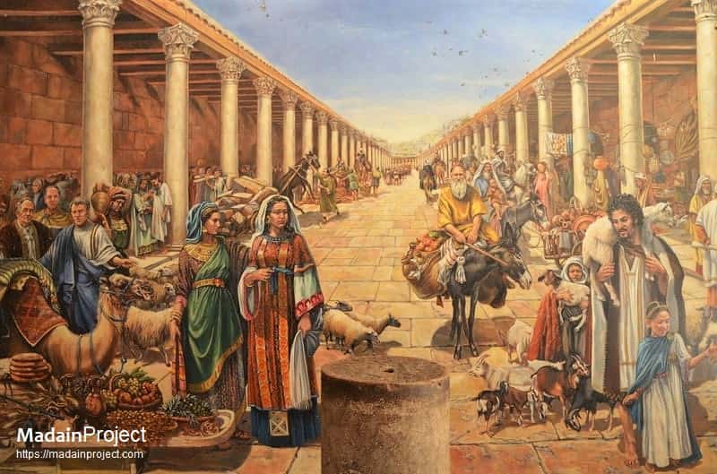
The cardo was originally a paved avenue approximately 22.5 meters wide (roughly the width of a six lane highway) which ran southward from the site of the Damascus gate, terminating at an unknown point. An illustration of how this main street might have looked in Roman-Byzantine times. The southern addition to the Cardo, constructed under Justinian I in the 6th century CE, extended the road further south to connect the Church of the Holy Sepulchre with the newly built Zion Gate.

circa 200 CE

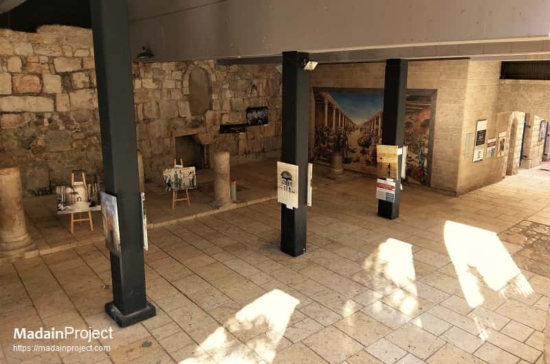
The line of the Cardo Maximus is still visible on the Jewish Quarter Street, though the original pavement lies several meters below the modern street level. In the 7th century, when Jerusalem fell under Muslim rule, the Cardo became an Arab-style marketplace. Remains of the Byzantine Cardo were found in the Jewish Quarter excavations beginning in 1969. The minaret of Caliph Omar Mosque and the Hurva Synagogue as seen from across the southern section of Roman Cardo.
circa 200 CE

Corinthian Columns
There are only five full columns standing to their original and one to partial height. Situated in the heart of the Jewish Quarter the exposed length of this section is about 150 meters and some 2.5 meters below modern street level. Simple bases (inspect) supported monolithic shafts, spaced 5.77 meters apart. The shafts supported Byzantine-style Corinthian capitals – intricately carved (inspect), but more stylized versions of their Classical counterparts.
circa 200 CE

Remains of the Shops
The Byzantine street was open to the sky in the center, but was covered on both sides with terra cotta tiles supported by wood planks. Along its length, the roadway was divided into three parts: two colonnaded covered walks flanking a 12 meter wide road.
circa 200 CE

Stalls/Workshops
The wall of the Cardo's eastern portico featured an arcade that housed various stalls and workshops leased by craftsmen and merchants. The shaded porticoes provided separation of pedestrian traffic from wheeled carts, shelter from the elements, space for small-scale commerce, as well as opportunities for residents and visitors to gather and interact.
circa 200 CE

Pavement
The central open pavement provided commercial access as well as ritual space. Some of the excavated Cardo sections are located under the modern houses of the Jewish quarter. The following photo shows a reconstructed section, with the wooden roof planks. The pillars and some of the bricks are from the original Byzantine road.
circa 200 CE
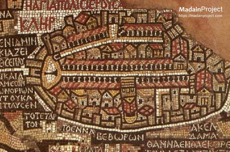
Depiction on the Madaba Map
The part of Madaba map that depicts the historic city of Jerusalem with the Cardo Maximus in the center as a colonnaded street. Two important structures along the cardo were Nea Church and Holy Sepulchre. The Cardo's most striking visual feature was its colonnade, clearly depicted on the Madaba Map.
circa 200 CE

Depiction in the Gallicantu Model of Jerusalem
A model of the Byzantine city displayed in Saint Peter Gallicantu shows how central was the Cardo Maximus. It is seen here from the side of Damascus gate on the north (bottom right), straight across the entire city towards the Nea (on the far left side) and the Holy Sepulcher (on the right side) in the middle of the road. Damascus Gate is the only Jerusalem gate to have preserved the same name since at least the 10th century (i.e. Bab al-Amud).
circa 200 CE

Modern Street called HaKardo along the ancient Roman-Byzantine Cardo Maximus, the ancient remains are to the right in lower levels. Artist's impression of how this road would have looked like in its hayday.


Signup for our monthly newsletter / online magazine.
No spam, we promise.
The Madain Project is an online archive of Abrahamic History and Archaeology.
Abrahamic History & Archaeology is the study of history and archaeology with respect to the three Abrahamic Faiths without considering the religious and theological aspects. The goal of Abrahamic History is to understand how and why the religious doctrines and behaviours have evlovled and changed over time. Searching for patterns in the evolution of significant cultural events such as the development of farming, the emergence of cities, or the collapse of major civilizations for clues of why and how these have influenced the three major Abrahamic religions.
Cloud Drive -
About -
Help -
Editorial Policy -
AI Policy -
Privacy Policy -
Contact
Madain Project: Encyclopedia of Abrahamic History & Archaeology.
Copyright MadainProject 2017 - 2026.
![]()
![]()
![]()
![]()
![]()
![]()